
|
|
Route |
|---|---|
|
|
39.11780°N / 106.4447°W |
|
|
Download GPX » View Route on Map |
|
|
Hiking |
|
|
Summer |
|
|
Half a day |
|
|
Class 2 |
|
|
Overview
This is not one of the standard routes on Mt. Elbert. Expect steep bushwhacking and solitude until the last 100 feet to the summit. The route is shown in red in the above pictureGetting There
(see directions for NE Ridge trailhead)Route Description
This is a route I climbed by mistake. I'm not sure if there's an established route here, as there is no trail and no review of the route. Taking this route requires a higher level of commitment, because after losing the initial game trail, the safest and most guaranteed way to get down is to get the summit and descend the standard NE ridge.
Begin at the trailhead for the Standard NE Ridge route. At the Colorado trail junction go STRAIGHT ahead. The trail here is very undefined, it looks to be either an old trail that is no longer in use or a game trail. Follow this. It will not last for very long and soon you'll find yourself bushwhacking. In the summer, there are a few other game trails in the area leading upwards. If you see one, and it's going up, take it. Try to stay close to the basin that Elbert Creek sits in, but don't descend into it. This should lead you to an old cabin and the false summit of Elbert will be in view.
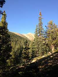 The false summit of the NE ridge becomes visible just below tree-line
 Continue in the same direction and break tree line. After you break tree line around 12,000', you will have this view of Elbert's North Face.
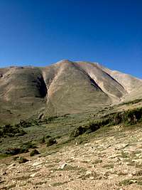 Elbert's North Face as seen from just above tree line
From this point you can gain the ridge at any point. Be advised that, although it looks very close, the ridge is still a very unpleasant, long, and steep climb from where you are. The best way to deal with this is to not go directly for the ridge, but rather to head diagonally uphill and west (towards the crest of the ridge). You'll kill two birds with one stone because you're trying to hit the low point in the ridge; a saddle just below the last, very steep class 2 section. As long as you head up and towards the obvious saddle, you can't go wrong. This will take longer than you think, expect to take at least an hour to get to the saddle.
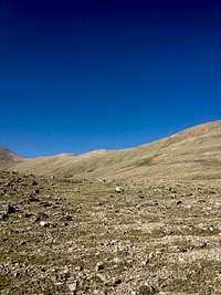 View as you approach the saddle
At the saddle, you're rewarded with spectacular views.
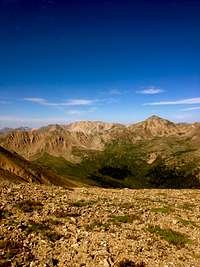 View looking west from the saddle
 This is the start of the class 2 section. It's steep and has some loose rock, but overall it's not very bad at all.
 Looking up from the bottom the class two section.
When you top out on this section you'll be right below the summit on the NE Ridge trail. Follow to the summit then descend on the NE Ridge trail.
This route is fun because you get to do some route finding on an otherwise very straight-forward and very crowded peak. I'm not sure if this adds or subtracts mileage, but it's definitely more energy consuming. It's a lot of fun and you'll have the peak to yourself until you summit!
 The standard NE route in in green, this route in in red
jcscratch1 - Aug 17, 2015 9:20 pm - Hasn't voted
Mt Elbert North TrailThe north trail starts at trailhead just past the Halfmoon Lake Campground on Forest Road 110 (from Leadville: south on 24, right on CR300, left on Halfmoon Road, right on FR110; totals 11.5 miles from leadville). The trail is very well defined the entire way to the summit, and is often referred to as the standard route. It starts as Trail 1776 for about a mile, then bang a right on Trail 1484 (it's marked, but the sign is washed out, but it's pretty obvious--just go up the mountain at this juncture). It's 4.6 miles from trailhead to summit. There's a steep section just prior to treeline, and a steep route-finding section (sketchy if you're not wearing hiking boots) from about 12,500 to 13,500. But you can wear sneakers and do just fine. The major drawback to this route is that you never see the summit until you get to the last false peak (where there is a large cairn) just 1/3 mile from the summit. But this route's trailhead is easier to get to by passenger car than the upper trailhead on the South Trail, so if you don't have a high clearance vehicle, you'll want to do this route. I don't know what route is described in this route description, but the north trail has been there a long time and has been climbed by thousands over the years.