
|
|
Route |
|---|---|
|
|
47.73810°N / 121.0053°W |
|
|
Scramble |
|
|
Half a day |
|
|
Class 3 |
|
|
Overview
This is the quickest way to the summit and probably the least technical. A competent party should be able to do the climb in 4 hours or less. The difficulties involved are modest brush on the slopes above Lanham Lake, a moderately steep snow or talus slope to the central notch, and an initial Class 3 scramble out of that notch.
This route and the mountain could be climbed year-round since there is year-round access to the trailhead (or at least to the turn-off from the highway). Skiers frequent the open upper Henry Creek slopes if the avalanche danger is minimal. They often use the Lanham Creek side for the approach, descending the Henry side. As a ski tour the summit is not generally the primary objective. The final summit scramble could be interesting in ski boots.
 |  |  |  |
Getting to the Trailhead
Drive Stevens Pass Highway either 5.8 miles east of Stevens Pass or 13.2 miles west from Coles Corner (14.5 miles west of Leavenworth) to a turn-off on the south about 0.5 miles west of where the powerlines cross the road. There is a sign saying Stevens Nordic Center. A short spur to the right leads to a parking area. The road continues but is gated in summer. It may be open in winter as the nordic center is just beyond the gate.
Lanham Lake Trail
The trailhead is at approximately 3,000 ft.
About 100 yards beyond the (black) gate, on the left, is the beginning of the Lanham Lake Trail. The trailhead is marked. The trail initially winds its way up to the powerlines, at which point pay close attention to where the trail picks up again on the other side of the powerline access road. Basically, you want to stay right (west) of Lanham Creek.
Find the trail (another signs at entrance to woods) and take it southward along the west side of creek for another 1.7 miles or so to the lake (4,143 ft). Total distance from the trailhead is about 2.2 miles. One hour to the lake on a very good trail.
Route to Summit
Cross to the east side of the lake's outlet and take a way trail around the lake for a couple hundred yards. When the light brush around the lake shows you a passage, leave the trail and travel uphill cross-country eastward, angling slightly to the south so as to be sure to pick up the 5,500-ft saddle immediately south of Pt. 5707. Pt. 5707 is a sharp gendarme crest so it is imperative to hit the saddle correctly. The slope up to the saddle is steep at times but never really cliffy. It is all forest. As is the saddle, though there are views into Henry Creek basin and out east and northeast to the Mt. Howard massif.
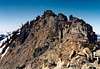
Follow the east semi-forested ridgeline south until below the final summits (East & West) at approximately 6,400 ft. Your next objective will be the obvious notch (6,640+ ft) between the summits. Depending on season, the final climb to the notch could be steep, hard snow (crampons handy), soft snow (snowshoes perhaps), or talus. There are some rock outcrops to break the monotony of it. When aiming for the notch, veer to its right (west) end to avoid the messy crags at its center. A nice rubbly ramp gets one up the final bit.
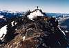
From this notch, simply follow the Main (West) Summit's final East Ridge all the way to the top. The first 100 feet is the hardest (Class 3). There is fall potential here owing to the slabby rocks with small holds, but once above that the crest eases back to Class 2 with the odd Class 3 move around obstacles.
Time = 4 hours +/- 30 minutes from the car
Distance = 3.5 miles one way
Gain = 3,700 ft
 |  |  |  |  |
East Summit Scramble
One can scramble up to the East Summit (6,680+ ft) from the central notch. It involves approximately 60 vertical feet of Class 3 with maybe about 10 feet of Class 4. There is no reason to try and climb up the east side of the East Summit to get to the West (Main) Summit by way of a traverse. The east end of the East Summit is unsavory looking--not hard but unsavory. Use the central notch to do both summits.
 |  |
Essential Gear
Ice axe unless really late in the season and all snow has disappeared.
Snowshoes if early season or winter.
If you think there will be hard snow, lightweight crampons would be advisable for the final slope to the notch. Else, leave them behind.