
-
 2183 Hits
-
 77.48% Score
-
 8 Votes
|
|
Route |
|---|---|
|
|
38.85050°N / 105.9428°W |
|
|
Hiking |
|
|
Spring, Winter |
|
|
Most of a day |
|
|
Overview
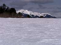
 Heading north, returning to parking
While shorter routes to the summit of Kaufman Ridge Highpoint exist in the snow-free season, this is an enjoyable route when snow is present. On paper, this route looks deceptively short and easy, but all that can change in deep snow. The trail breaking on this northeast slope can be dreadful. Expect a full day of wallowing in deep powder.
Surely one of the most rewarding things about this route is that the gonzo views remain hidden until you reach the summit. Suddenly, upon reaching the top, views of the Sawatch range simply explode before your eyes.
Roundtrip Distance: 5.5 miles
Elevation Gain: 1,200 feet
YDS Rating: Class 2
Getting There
 Sneak-a-peak views of the neighborhood
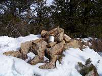 Summit Cairn, Kaufman Ridge Highpoint
From Hwy 285 / Hwy 24 (overlap) east of Buena Vista
Follow FS 318, what may be signed as “Buckrake Road” for approximately 3 miles to the US Forest Service boundary. In winter, you will encounter a winter closure gate. In summer, you may be able to proceed further.
Route Description

From the winter road closure/gate
• Strike out heading south-southeast across the meadow; depending on snow depth, faint elements of the underlying road may be discernable.
• Travel roughly three quarters of a mile until the road begins to gently descend a gulch and trends to the southwest; depart the roadbed and continue to the southeast staying on higher ground.
• About one mile after leaving the winter gate, pass a fenced corral to your right/west.
• Continue an additional approximately ¾ mile past the corral to gain the FS 308 roadbed.
• Follow the FS 308 roadbed for roughly another ½ mile before departing the roadbed in a meadow to begin ascending the northeast slope of Kaufman Ridge Highpoint.
• From here, ascend the increasingly steep slope through sometimes dense timber in a generally southwestward direction.
• The summit ridge appears suddenly and delightfully; the views of the Sawatch should astound.
• Enjoy lunch and take in the views before retracing your steps to your vehicle.
Essential Gear
 Looking back to the north
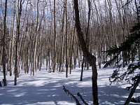 Dense timber on lower slope
• Flotation (snowshoes would be ideal given that much of the route travels steep, densely-timbered slopes).
• Trail Map (Either the USGS Castle Rock Gulch quad or a custom map will be necessary)
• Colorado Gazetteer or similar roadmap illustrating minor/dirt roads.
• Compass or GPS
• Water and snacks
• Insulated, water-proof boots
• First aid kit
• Camera