
-
 745 Hits
-
 72.08% Score
-
 2 Votes
|
|
Route |
|---|---|
|
|
Mountaineering |
|
|
Spring, Summer |
|
|
One to two days |
|
|
Class 3 |
|
|
Overview
Northwest Couloir is a moderate snow climb in absolute solitude deep in a remote corner of the Gore Range.
 Northeast Couloir - Peak L
Getting There
Brush Creek Trailhead:
From Silverthorne, drive north 16 miles on Hwy 9 and turn left on the Heeney Creek Road (CR 30.).
Without High Clearance: park at the Kansas Gulch-Grandview Cemetery - 0.7 miles to the right after turn off. Don't miss the marker with the interesting (and tragic) history of the first settlers in this area.
With High Clearance: turn sharp left 0.6 miles after turn off onto FS 1695. After the first switchbacks you will run into three wide holes in the road next to each other - each at least one foot deep (2023). This is section is impassable for any sedan and prob most SUVs. If you try you may get stuck and/or lose your oil pan /exhaust in the process of it. Brush Creek road is not maintained; this section will only get worse in the years to come.
The next first half mile is a steep, rocky and narrow dirt road with only enough space for one car. Meeting a car on one of the steep ascents may put you into a tricky spot. Any rain will turn the road into a slippery mess. The road relents after the initial climb but there are still several deep ruts to be mastered until you reach the Brush Creek Trailhead. Plenty of parking spots at the trailhead.
Notice: FS 1696 is closed for vehicle traffic between Nov 20th and June 23rd - the gate right at the beginning of the forest road will be locked.
Route Description
From Brush Creek TH hike to the junction with Gore Range Trail. Turn right (Northwest) on Gore Range Trail until reaching the junction with Lost Creek Trail. Turn left (Southwest) onto Lost Creek Trail.
About half way to Lost Lake from the junction you will enter a patch of dead pine trees. The most Southern part of the patch forms a flat and narrow pass between the Brush Creek and Black Creek Drainage (right South of Point 9795). One can see Dora Mountain through the trees on the other side of the Black Creek Valley.
Leave the trail to your right (West) and hike the 60 ft or so to the steep drop off down to the Black Valley. The tricky part is that (status 2023) there is no trail whatsoever indicating where to turn off from Lost Creek Trail - it's just brush and fallen trees. When reaching the drop off look around a bit and (almost) miraculously a well built 2 ft wide trail starts right at the edge of the drop off and leads into the Black Creek Drainage.
The trail skirts almost level around the North side of Guyselman Mountain and switchbacks eventually up into the South Black Creek Valley. National Forest & volunteers seem to clear the path once in a while, but expect to climb over and under tons of fallen trees.
The trail will eventually drop you off in a large meadow along the South Black Creek.
Cross the meadow and a faint climbers & game trail is continuing further up the valley. Trail is often hard to follow, in doubt stay closer to the mountainside instead of following the creek closely. Right before the valley makes a right turn around The Elephant you will cross a larger meadow, Peak L is right above you. This meadow is the last feasible spot for a nice camp.
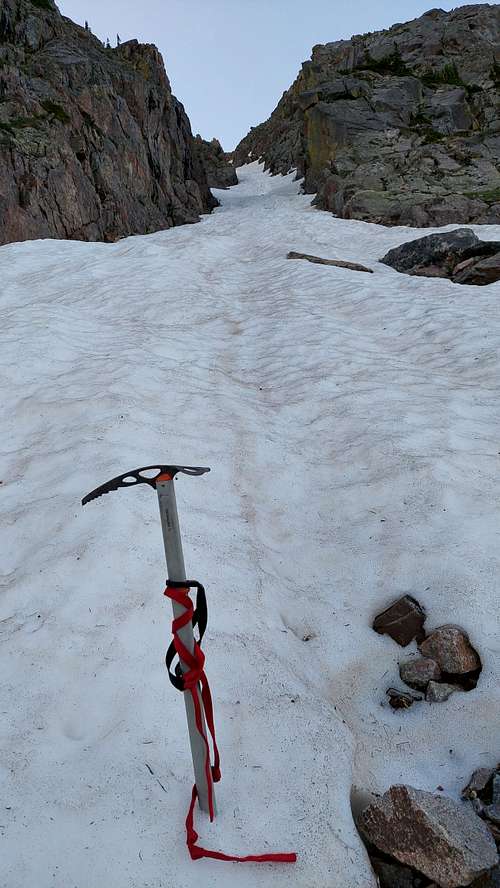
Northwest Couloir is to the right (West) of Peak L. Until early summer a snow field is extending from the exit of the couloir down to the valley bottom. Later in summer it is best to hike over a talus field along the mountainside up to the entrance of the couloir.
From below the couloir looks rather short, but this is an optical illusion - as you can see probably less than half of its length from below. The couloir is a very moderate snow climb. I was fine with crampons and my hiking stick ( did not use the ice axe). After you gained the rigde it is a Class 3 climb to the summit.
Return trip:
1) return as you came down the couloir
2) scramble down to Upper Slate Lake and hike back to Brush Creek TH via Gore Trail
3) via Gore Thumb to Lost Lake and back to Brush Creek TH via Lost Lake Trail.
The ridge connecting Peak L with Peak M sporting Gore Thumb is a Class 5 climb. The ridge can be bypassed on the South but you must tediously downclimb ( Class 3 to 4) into a deep ravine, climb out again and climb over the ridge on its Nothern Side up a narrow couloir. Bypass the next tower and hike up a moderate ravine to finally make it to the East Ridge of Peak M. When you finally make it down to Upper Brush Creek Valley below Peak M you have to tackle a looong talus field which will make you cry...and then bushwhack along the creek through dense, swampy and seemingly never ending Gore forest down to a wide clearing. From here follow the creek to another clearing just a couple minutes away. Lost Lake Trail is crossing the creek right at the end of the clearing. Lost Lake itself is not visible from the creek. Turn right on Lost Lake Trail and it delivers you eventually to Gore Trail. Turn left and eventually you return to the junction with Brush Creek Trail. This will make for a very very long day!
Notice: this route takes you into some of the most remote areas of the Gore Range - you will be completely on your own if anything goes wrong.
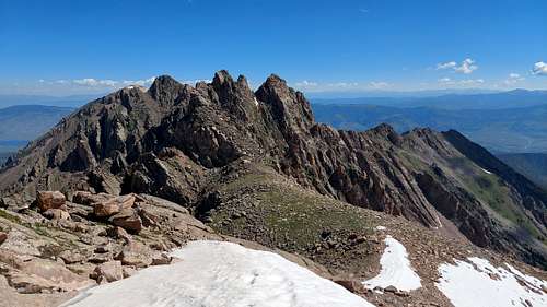 Gore Thumb from Peak L
Essential Gear
Crampons, helmet, hiking stick, ice axe - and TONS of DEET. The swampy valleys around Peak L are home for a gazillion of mosquitos