
|
|
Mountain/Rock |
|---|---|
|
|
36.43167°N / 71.82833°E |
|
|
24580 ft / 7492 m |
|
|
Overview
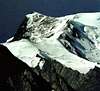
CLIMBING HISTORY At 7492m Noshaq is the fourth highest peak of the Hindukush range and the highest in Afghanistan. The mountain has four separate peaks . The main peak was climbed in 1960 along the south east ridge from the Qadzi Deh glacier by a Japanese expedition led by Professor Sakato. Other members of the expedition were G. Iwatsabo and T. Sakai. The second highest peak in this range is Noshaq East at 7480m climbed in 1963 by Dr Gerald Gruber and Rudolf Pischinger from Austria. The third highest peak of the range Noshaq Central is 7400m . The Austrian expedition of 1963 of Dr Gerald Gruber and Rudolf Pischinger are also credited with climbing the fourth peak of Noshaq range called Noshaq West at 7250m.
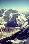
The Afghan route follows the west ridge from where it is a relatively straightforward ascent and a polish expedition in 1973 made the first winter ascent successfully. During the Russian war the low Sad Istragah pass was used as a mujahedin supply route and some of the adjoining areas around Qazi Deh was heavily mined which does somewhat make it a risky. The Pakistan route has now considerably eased out permit regulations techinically this is the difficult route. CLIMBING ROUTE The peak is accessible through both Pakistan & Afghanistan as it is right on the border. Logistically the route through Pakistan is more convenient as things are more organized from this end. You follow the Tirich Mir route through the Lower & upper Tirich glaciers to Babu camp From here you branch out from the upper Tirich glacier towards Noshaq base camp. The climb involves crossing a moraine between two icefalls then a scree slope to the south ridge. The two ice falls flowing from Noshaq make it a technically difficult ascent from this side , three camps are established before final ascent is made.
Alternately the other route through Afghanistan is from Badakshan & Wakhan. Though we have been organizing things in this area for the last 12 year but logistically its quite demanding. Approaching the peak through Afghanistan cost wise is more expensive as the area is still in the process of settling down and stabilizing, one has to " constantly relocate connection” over there !.
 |
 |
 |
Getting There
ROAD ROUTE Across the Lowari pass to Chitral town , take time to see the Kalash valleys. Then the jeep road goes as far as Shahgrom but an alternate route over Zani pass is an excellent way to both acclimatize and get a good perspective of the major peak before you reach Shahgrom. PORTER The porter stage go a day further, aprox 4 hrs beyond Babu camp across an ice field ( that is if you can convince the porters to go that far ). Rates in the Tirich valley is a flat Rs 1200 per stage. Avoid hiring at high prices but you can compensate by tipping well if good service is provided. Use your local Pakistani connections to maintain a steady balance of prices and service for those who follow you into these mountains. TRANSPORT Jeep rates to road head were as follows in 2016.
• Chitral to Shahgrom Rs 11000 • Chitral to Zani Rs 9500 1$ = Rs 103 in 2016 FLIGHTS There is now four flight from Islamabad to Chitral on Sun.Mon.Wed & Friday Similarly there are four flights from Peshawar to Chitral. PROVISION Chitral is well stocked with essentials for trekking/mountaineering expeditions but avoid purchasing tinned food stuff from the bazaar as they are mostly expired/outdated and liable to cause problems during your expedition . Also there is very little variety while Islamabad bazaars are well stocked. It is best to purchase some of the essential food from Islamabad where expeditions spend a day or two for permit requirements. HOTELS ENROUTE Chitral now offers a variety of hotels a perfect base is www.Ayunfortinn.com besides many others. For good food try a local place at Dainin, after crossing the chew bridge turn right ,near the pump ask for Golani restaurant… no mention in books but what the local flood too. The Afghan restaurants both on Goldoor road or Krubrisht provide good food. The Chapal Kebabs are best near Polo ground.
POLLUTION The area is relatively clean compared to the Baltoro but with Peak royalties reduced there is going to be a influx of visitors. Please ensure that you leave the camps pristine and insist on your programme operator to carry back garbage to road head. A policy is being framed by the locals to check that Pakistani tour operators follow the guide lines.
 |
 |
Red Tape
RED TAPE 2016 Expeditions to the Hindukush Mountain have restarted after the area being closed for some time. The Khyber Pakhtunkhawa ( previously NWFP ) provincial government is very helpful in streamlining permit briefings etc. Hindukush Trails has been successful in convincing them to take L.O from Chitral Scouts to easy procedures and related formalities to help expeditions. Royalty to the peaks in the Hindukush have now been reduced considerably. This is an excellent opportunity to now do mountaineering at lower costs in the Hindukush region. Peak royalty charged by government is as follows. SUMMERS Height Full Team 7 members Each Additional Member 7501m to 8000m $ 400 $ 50 7001 to 7500m $ 250 $ 30 6501 to 7000m $ 150 $ 20 Below 6500m free WINTERS Height Full Team 7 members Each Additional Member 7501m to 8000m $ 200 $ 25 7001 to 7500m $ 120 $ 15 6501 to 7000m $ 75 $ 10 Below 6500m free While making your arrangements going through a local operator definitely helps you in many ways both to effectively deal with last minute changes, permit requirements as well as porters logistic etc. At Chitral the foreigners registration is essential and hardly takes any time.
When To Climb
Depending on winter snows best time is June, July & August winter ascents have been made on this peak
Camping
CAMPING RATE Camping rates in the Hindukush are reasonable, per tent you are charged Rs 50 . You are only charged at Shahgrom not on route further. Camps are set at traditional places on route and there is no hassle on this.
Mountain Conditions
Local info is available from E mail info@hindukushtrails.com Tel 0092 51 2222778 0344 5010602 Hindukush Trails organizes trekking and Mountaineering in the Hindukush and Karakorum Mountains of Pakistan
EXPEDITIONS PERMITS
The Federal Ministry of Tourism has been devolved giving the provincial governments the regulating authority in deciding on permits. We will now be getting permits for the Hindukush and HinduRaj mountains from the Khyber Pakhtoonkhwa provincial government.
External Links
- Jasmine Tours - Pakistan We are one of the experience Mountaineering Expeditions organizer to the Hindu Kush and Hindu Raj mountains.
aaporik - Feb 11, 2006 9:03 am - Voted 10/10
Untitled CommentDo you remember which route they ski down, from Pakistan side or from Afghistan side. A German Expedition climb Noshaq in 1974 from Afghistan side.
aaporik - Dec 24, 2005 12:44 am - Voted 10/10
Untitled CommentLike all mountains in Karakoram, Himalaya, Hindu Raj and Hindu Kush Rawalpindi - Islamabad is the gateway to the high mountain of northern Pakistan. Islamabad International airport link the world with dozens of international flights each day. One can reach Chitral by two road links #1 is via the Lawari Pass; One can take a road journey on Grand Truck Road also known as GT road towards NWFP and after about 2 hours turn right to the Mardan Valley before climbing the famous Malakand Pass (this is area where first time British Soldier wear Khaki uniform - Shalwar Kameez, which still the Pakistani soldier wear in this area) the same which link to Swat Valley, one can have lunch in roadside Afghan resturants before turn left to Dir and further to Lawari Pass. All the road journey from Islamabad to Chitral will take about 10 to 12 hours. One can also fly from Peshawar to Chitral. Be prepared for delays due to bad weather, road blockage in the Lawari Pass Section due to landslides.
#2 road link is via the KKH to Gilgit and by the Shandur Pass (the famous and the height Polo ground on earth) to Chitral. Gilgit is about 16 to 18 hours from Islamabad and road journey to Chitral from Gilgit is another day drive.
aaporik - Feb 11, 2006 9:03 am - Voted 10/10
Untitled CommentDo you remember which route they ski down, from Pakistan side or from Afghistan side. A German Expedition climb Noshaq in 1974 from Afghistan side.
Corax - Jun 25, 2009 2:22 pm - Hasn't voted
Afghani team pagePerhaps you can add this link to the page: http://www.noshaq.com/index.php It's a nice page about an Afghani team attempting Noshaq.
hgrapid - Jul 12, 2009 12:35 pm - Hasn't voted
Off by 20 milesYour coordinates are off by 20 miles. The mountain is 20 miles northeast.
mohykan9 - Oct 1, 2016 9:28 am - Hasn't voted
Noshaq form Afghan sideDetail howto climb Noshaq from Afghan side from logistic, transport to climb. https://medium.com/@palodraxler/how-to-climb-noshaq-68ff49b10217
kocowaty - Feb 28, 2019 12:26 pm - Hasn't voted
Noshaq solo climb in 20182018 was a good season. There was a solo Noshaq climb by Łukasz Kocewiak from Afghan side and the first Afghan woman, Hanifa Yousoufi managed to ascend the mountain. Due to the varied nature of the expedition, it is difficult to place it in one category. Several characteristic aspects are the following: - a journey through Central Asia, i.e. Tajikistan and Afghanistan; - traveling through a war-torn country in the immediate vicinity of an armed conflict; - the cultural and anthropological character of the expedition, that is to know the unique Wakhi people culture; - climbing part (estimated M4), i.e. an area requiring the use of technical ice axes at the altitude of 6800 m; - organization of a high-mountain expedition from scratch in an area without infrastructure and agency support; - practically alone in the Afghan Hindu Kush and ascent to the highest peak of Afghanistan, which is 7492 m high. More details here: https://youtu.be/USR0fPDAhO4.