Synopsis
Being a lifelong Calgarian who really likes mountains, the nearby Kananaskis Country provides an excellent playground. The Opal Range is a strikingly sharp and rugged range that provides a jagged transition from the low foothills to the main range along the continental divide in K-country. Over the years I climbed the occasional Opal Range peak, but didn’t really consider the entire range as an objective. Now I have. I have compiled a wish list of 35 Opal Range summits or highpoints; most of these are unofficial summits, but many have significant prominence and isolation. Below is a summary table that I will update over time as I tick off these highpoints. I am not in rush to complete this project, but likely to complete in the list in about 4 or 5 years? A detailed description of peak prominence and general facts about these mountains follows.
Tick List
| Highpoint reference |
Highpoint elevation (m) |
Climbed ? |
| Mt. Evan-Thomas |
3097 |
YES |
| Elpoca Mtn. |
3036 |
YES |
| Tombstone Mtn. |
3029 |
YES |
| ’Ripsaw’ |
3008 |
not yet |
| Mt. Packenham |
3000 |
YES |
| ’Mt. Potts’ |
3000 |
YES |
| ’Mt. Denny’ |
3000 |
YES |
| ’Tombstone South’ |
3000 |
YES |
| Mt. Jerram |
2996 |
YES |
| Mt. Blane |
2993 |
YES |
| ’Cat’s Ears - north’ |
2960 |
not yet |
| ’Cat’s Ears - south’ |
2960 |
not yet |
| Mt. Burney |
2934 |
YES |
| ’Mt. Barham’ |
2920 |
not yet |
| ’The Blade’ |
2920 |
not yet |
| 'Rocky Peak' |
2915 |
YES |
| Mt. Hood |
2903 |
YES |
| Mt. Brock |
2902 |
YES |
| ’Mt. Schlee’ |
2850 |
YES |
| ’South Schlee’ |
2800 |
YES |
| ’Little Tombstone’ |
2800 |
YES |
| Mt. Wintour |
2700 |
YES |
| ’Elpoca Tower’ |
2680 |
YES |
| Gap Mtn. |
2675 |
YES |
| The Wedge |
2667 |
YES |
| ’Little Evan’ |
2665 |
YES |
| Opal Ridge (north) |
2575 |
YES |
| Opal Ridge (south) |
2575 |
YES |
| ’Grizzly Peak’ |
2545 |
YES |
| ’Opoca Peak’ |
2480 |
YES |
| ’Mt. Mackay’ |
2455 |
YES |
| ’Mackay Hills - centre’ |
2440 |
YES |
| ’East Opoca’ |
2425 |
YES |
| King Creek Ridge |
2425 |
YES |
| Limestone Mtn. |
2173 |
YES |
What is the Opal Range?
When I first had the thought to climb all the summits of the Opal Range, I wasn’t really sure of the boundaries of the range. The only two written descriptions of the range I found seemed off. These both ended the northern edge of the range along Rocky Creek, between The Wedge and Opal Ridge. This effectively makes The Wedge, Limestone Mountain and the Mackay Hills their own mountain range. One of the descriptions included several mountains in the Elbow River loop area, but these mountains are clearly in the Fisher Range, had the same physical structure and rock composition of the Fisher Range and had a major drainage system separating them from the Opal Range.It seems logical to me that the major valley bottoms and primary passes provided the most definitive boundary of any mountain range. Physical formation and rock composition of mountains help with the fining tuning of the boundaries. In my view, The Wedge is very similar in composition and formation to the main range of the Opals, also Evan-Thomas Creek is a higher order stream with a much larger valley than Rocky Creek, thus I included this small cluster of minor peaks. Other major water courses and passes seemed obvious to me and I defined the Opal Range with an approximate area of 185.0 square kilometres (70 square miles) using the area bounded by the Kananaskis River/Pocaterra Creek, Evan-Thomas Creek, the Little Elbow River and a small section of the Elbow River. These principle watercourses flow from several primary passes; Tombstone Pass (2270m), Evan-Thomas Pass (2180m) and Elbow Pass (2085m).
How many peaks are in the Opal Range?
Good question. The number of officially named mountains is easy. Until 1961, the Federal Government of Canada through the
Geographical Names Board of Canada had jurisdiction over all geographical names, since then the relative Provincial Government has the authority. In Alberta, the
Geographic Names Program reviews and approves any geographical name.Within the land area of the Opal Range I defined there are 15 officially named summits. There are about 10 peaks with “local names” that seemed to be somewhat accepted or used on frequent basis.At first when I was conceptualizing this project I was only going to seek out the officially named summits, but there are many interesting summits that do not have certified names, several with cool routes. Then I was only going to climbed “interesting” peaks, but what does that mean? Looking at an analysis of prominence to identify “true” summits was my next method, but similar to the interesting peaks, this is also difficult determine. There is no set standard of measurement or degree of separation to determine a separate summit by any of the governing bodies in Canada, nor could I determine any consistent method from other nations. Also, many of the methods would eliminate highpoints that I want to climb because of the route, or interesting position. In the end I decided that any summit with a prominence of 100 metres or more, and any highpoint that was interesting to me, I would ascend. This way I get to climb more peaks! This works out to 35 highpoints in the Opal Range.
Analysis Method
When I was investigating the prominence measure as a method to determine the appropriate number of summits, I did perform an analysis of all the ridgelines in the Opal Range. Using the Federal Government of Canada, National Topographic Maps, I measured the prominence of all significant highpoints. When determining the height of the intervening key saddle or col, I used the pessimistic approach and used the highest elevation contour line of the col. As an example, the exact elevation of the col between ‘Grizzly Peak’ and Mt. Evan-Thomas is unknown and lies between the 2400 and 2440 metre contour lines. For the prominence calculation, I used 2440 metre as the col elevation, thus ‘Grizzly Peak’ has a prominence of 105 metres and Mt. Evan-Thomas, 657 metres from this shared col.
The Big Table
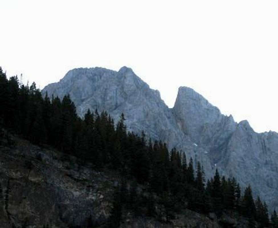
I have summarized the prominence analysis in a big table. This table is abridged version of my working excel table, but it highlights the prominence of all highpoints to two of its immediate neighbours. Mt. Evan-Thomas has four neighbours sharing connecting ridge lines. Mt. Hood, Mt. Jerram, ‘Cat’s Ears – south’, ‘Mt. Schlee’, Mt. Elpoca and Tombstone Mtn. (north) have three immediate neighbours. The full sized table was becoming difficult to display on screen so the neighbouring highpoints was reduced to two. Please refer to the two maps that show the contour line analysis following this table for all saddle to highpoints calculations. Interesting facts; there are two saddles that have a prominence of zero. This relates to the coarse scale of the topographic maps and the 40 metre (131 foot) contour lines. The two saddles relate to unofficially named highpoints and include the saddles between the Mt. Blane and ‘The Blade’ and Elpoca Mtn. and ‘Elpoca Tower’.
![Mt. Blane and ‘The Blade’ Col]() Mt. Blane and ‘The Blade’ Saddle Mt. Blane and ‘The Blade’ Saddle |
![Elpoca Mtn. and ‘Elpoca Tower’ Col]() Elpoca Mtn. and ‘Elpoca Tower’ Saddle Elpoca Mtn. and ‘Elpoca Tower’ Saddle |
There are five saddles with more than 600 metres (1969 feet) of prominence (highest measurements, not including the lower highpoint elevation), the greatest being the saddle between Mt. Wintour and Mt. Jerram at 676 metres (2218 feet); saddle at 2320m and Jerram summit at 2996m (prominence to Mt. Wintour is 380m).
![Highest prominence in the Opal Range]() Mt. Wintour and Mt. Jerram Saddle. Mt. Jerram in background. Highest prominence in the Opal Range at 676 metres (2218 feet) Mt. Wintour and Mt. Jerram Saddle. Mt. Jerram in background. Highest prominence in the Opal Range at 676 metres (2218 feet) |
![Wintour/Jerram Col - Mt. Wintour to right]() Mt. Wintour and Mt. Jerram Saddle. Mt. Wintour to right. Prominence to Wintour Summit is 380m. Mt. Wintour and Mt. Jerram Saddle. Mt. Wintour to right. Prominence to Wintour Summit is 380m. |
Excluding the two saddles with zero prominence, there are 12 saddles that have less than 100 metres of prominence, but only two non officially named highpoints with less than 100 metres on all adjacent saddles; ‘East Opoca Peak’ and ‘Cat’s Ear – north’. I had considered deleting these highpoints from the list, but both summits have some interesting climbing or scenic value, and with the coarse measurement of the 40 metre contour lines, and the pessimistic saddle height method; I decided to include these highpoints. The list in the table starts with the most northern summits in the range, then proceeds southward in the list.
| Highpoint reference |
Highpoint elevation (m) |
saddle A (m) |
saddle B (m) |
neighbour A (m) |
neighbour B (m) |
prominence A (m) |
prominence B (m) |
| Limestone Mtn. |
2173 |
2120 |
- |
2667 |
- |
53 |
- |
| The Wedge |
2667 |
2120 |
2320 |
2173 |
2455 |
547 |
347 |
| GR 323350’Mt. Mackay’ |
2455 |
2320 |
2280 |
2667 |
2440 |
135 |
175 |
| GR 333341’Mackay Hills - centre’ |
2440 |
2280 |
2320 |
2455 |
2340 |
160 |
120 |
| Opal Ridge (north) |
2575 |
2480 |
- |
2575 |
- |
95 |
- |
| Opal Ridge (south) |
2575 |
2480 |
2400 |
2575 |
3000 |
95 |
600 |
| GR 334290’Rocky Peak’ |
2915 |
2800 |
- |
3000 |
- |
115 |
- |
| GR 336280’Mt. Denny’ |
3000 |
2800 |
2880 |
2915 |
3000 |
200 |
120 |
| GR 339269’Mt. Potts’ |
3000 |
2880 |
2880 |
3000 |
3097 |
120 |
120 |
| Mt. Evan-Thomas |
3097 |
2880 |
2440 |
3000 |
2545 |
217 |
657 |
| GR 328249’Grizzly Peak’ |
2545 |
2440 |
- |
3097 |
- |
105 |
- |
| GR 373253’Ripsaw’ |
3008 |
2600 |
2480 |
3097 |
2665 |
408 |
528 |
| GR 385256’Little Evan’ |
2665 |
2480 |
- |
3008 |
- |
185 |
- |
| Mt. Packenham |
3000 |
2760 |
2760 |
3097 |
2903 |
240 |
240 |
| Mt. Hood |
2903 |
2760 |
2720 |
3000 |
2902 |
143 |
183 |
| King Creek Ridge |
2425 |
2240 |
- |
2903 |
- |
185 |
- |
| Mt. Brock |
2902 |
2720 |
2600 |
2903 |
2993 |
182 |
302 |
| Mt. Blane |
2993 |
2600 |
2920 |
2902 |
2920 |
393 |
0 |
| GR 361210’The Blade’ |
2920 |
2920 |
2800 |
2993 |
2920 |
0 |
120 |
| GR 363205’Mt. Barham’ |
2920 |
2800 |
2800 |
2920 |
2934 |
120 |
120 |
| Mt. Burney |
2934 |
2800 |
2840 |
2920 |
2996 |
134 |
94 |
| Mt. Jerram |
2996 |
2840 |
2920 |
2934 |
2960 |
156 |
76 |
| Mt. Wintour |
2700 |
2320 |
- |
2996 |
- |
380 |
- |
| GR 383179’Cat’s Ears -north’ |
2960 |
2920 |
2920 |
2996 |
2960 |
40 |
40 |
| GR 385179’Cat’s Ears -south’ |
2960 |
2920 |
2600 |
2960 |
3029 |
40 |
360 |
| GR 385168’Mt. Schlee’ |
2850 |
2680 |
2720 |
2960 |
2800 |
170 |
130 |
| GR 374159’East Opoca’ |
2450 |
2360 |
2360 |
2850 |
2480 |
80 |
80 |
| GR 368155’Opoca Peak’ |
2480 |
2360 |
- |
2440 |
- |
120 |
- |
| GR 388157’South Schlee’ |
2800 |
2720 |
2680 |
2850 |
3029 |
80 |
120 |
| Elpoca Mtn. |
3029 |
2680 |
2400 |
2800 |
2675 |
349 |
629 |
| Gap Mtn. |
2675 |
2400 |
- |
3029 |
- |
275 |
- |
| GR 401140’Elpoca Tower’ |
2680 |
2680 |
- |
3029 |
- |
0 |
- |
| Tombstone Mtn. |
3029 |
2600 |
2760 |
2960 |
3000 |
429 |
269 |
| GR 407165’Tombstone South’ |
3000 |
2760 |
- |
3029 |
- |
240 |
- |
| GR 396213’Little Tombstone’ |
2800 |
2640 |
- |
3029 |
- |
160 |
- |

 7277 Hits
 73.06% Score
 3 Votes
 Mt. Blane and ‘The Blade’ Saddle
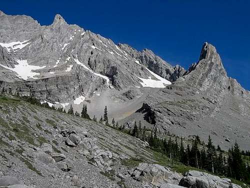 Elpoca Mtn. and ‘Elpoca Tower’ Saddle
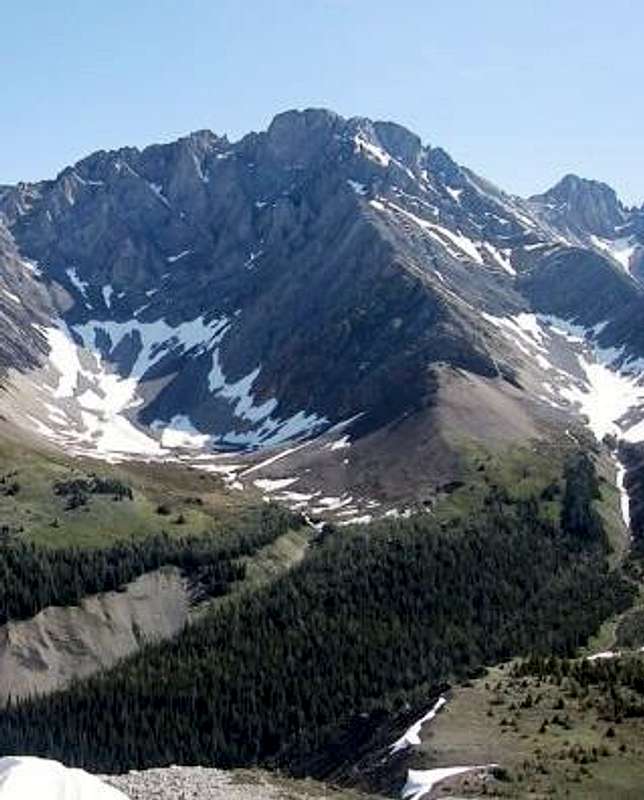 Mt. Wintour and Mt. Jerram Saddle. Mt. Jerram in background. Highest prominence in the Opal Range at 676 metres (2218 feet)
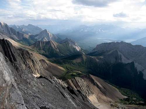 Mt. Wintour and Mt. Jerram Saddle. Mt. Wintour to right. Prominence to Wintour Summit is 380m.