
|
|
Route |
|---|---|
|
|
38.95890°N / 104.9073°W |
|
|
Hike |
|
|
Half a day |
|
|
Walk-up |
|
|
Approach
The start of this route is the Blodgett Peak Open Space trailhead off of Woodmen Rd. This is a well-used city open space, so parking may be an issue on busy days. The city has a nice map of the Open Space trails.
Facts
Starting Elevation: 7064'
Summit Elevation: 9423'
Length of Route: 2 miles one way
Route Description
The trail starts out as a dirt road which is a very straight-forward climb. Pretty soon this road comes to a big green water tank where you turn left and start the real climb.
A little way up, the trail gets a bit confusing because there are several trails that crisscross, but as long as you keep heading into the valley to the south of the peak you can find your way.
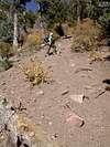
Once you get into the valley, there will be some pretty nasty loose scree sections that will likely aggravate you on the way down. If you want more of a challenge, there are some nasty rock fields that you can climb up once you get about 3/4 of the way up.
Otherwise the main trail continues shooting straight up without very many switchbacks and heads into the saddle just to the west of the summit. Once you get to that saddle, the summit is just a little rock scramble away.
 |  |
Essential Gear
Since there are a few scree slides on this trail, it's a good idea (wish I'd have thought of it before) to bring some gaiters to keep the rocks out of your boots. Also some trekking poles may be in order to keep a little bit of balance while sliding back down those scree slopes.
Otherwise bring plenty of water AND a good map of this area. Since there are so many trails crisscrossing in here, a general map of the mountain is pretty much mandatory.