
|
|
Route |
|---|---|
|
|
40.39600°N / 105.901°W |
|
|
Scramble |
|
|
A long day |
|
|
Class 3 |
|
|
Finding the Trailhead
The Colorado River Trailhead is located along Trail Ridge Road (Rt 34) going through Rocky Mountain National Park (RMNP). The trailhead is on the west side of the Continental Divide but can be easily reached from Estes Park, CO during the summer months (May/June - September) when Trail Ridge Road is open.From the East, take I -25 (Colorado) to the exit for highway 34. Continue west on 34 up the canyon and through Estes Park. Staying on 34, pass through the gate to Rocky Mountain National Park. You are now on Trail Ridge Road and it will take about 45 minutes - 1 hour to reach the Colorado River Trailhead (a few miles beyond Milner Pass).
From the West, take highway 40 (Colorado) to highway 34 north/east toward Grand Lake. Again, pass through the gates to Rocky Mountain National Park and drive approximately 8/9 miles to the Colorado River Trailhead.
Route Description
Starting at the Colorado River Trailhead, head north 1/2 mile until the intersection with the Red Mt. trail. Take the Red Mt. trail that leads west past the Colorado River and through a meadow before the route starts gaining elevation. The trail crosses Opposition Creek and continues southwest passing through a dense and lush forest that I assume few visitors to the National Park ever see. After more than a mile the trail makes a severe switchback leading northeast that will eventually connect to the Grand Ditch Road.I chose to stay on the trail, however, if you left the trail and climbed steep terrain to the west, the Grand Ditch Road would be not far away and impossible to miss. Staying on the trail, the Red Mt. Trail ends at the intersection with the road about 3.3 miles from the trailhead. The next .9 miles of road south along the Grand Ditch is a flat (.2% grade) that I find relaxing and an interesting historical reminder of our westward expansion days. Leave the road at the bridge leading across The Ditch where a sign indicates Opposition Creek campsite.
Follow this narrow path until you reach the campsite at the base of a large and steep rockslide. Staying to the left side of the campsite and rockslide there's a trail that will lead west into forest and follow the nearby Opposition Creek. After a short distance the trail becomes faint and a swampy meadow is visible through the trees to the left (south). At the west end of the meadow starts the bouldering that will continue until the summit of Nimbus, which has not come into sight.
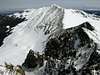
As shown in the picture, follow the green rocks west and up until you reach a level area where you are now enclosed at treeline with the Red Mt. ridge to the south and west and the vast boulderfield that trickles down from the saddle between Nimbus and Cumulus far away and tucked out of sight to the northwest.
I stayed to the south of the closer lumpy ridge as seen in the "saddle" photo and traversed snow sections where the incline wasn't too steep. One snow traverse led us to a rocky section where we had to climb class 3 rock in order to continue gaining elevation. This was so much fun and the views below were incredible.
After the climb, you'll continue west past a lake of snowmelt. We chose to descent a steep 100 vertical feet across boulders taking us closer to the lake and closer towards a less steep snow traverse that what lied due west. Nimbus comes into view for the first time on this hike and lies to the southwest while Cumulus can be seen to the northwest.
The rest of the way is a basic mountain scramble. We had a lot of snow to contend with and made our way up to the Continental Divide ridge north of Nimbus but south of the un named peak that extends a ways east of the Divide between Nimbus and Cumulus.
It took us 7 hours to reach the summit of Nimbus due to the difficulty of the terrain at the time. On the descent, we were able to glissade areas that were too steep for us to ascend, saving much time. We also returned on the north side of the lumpy ridge - following closer to Opposition Creek as we made our way back to the Grand Ditch Road.
Hike Totals: 12 miles
10 hours
This was the first climb that I used an ice axe (mine). Great tool for any type of snow traversing and especially useful for testing snow strength near rocks during warm summer weather.
 |
Essential Gear
MapCompass
Ice axe - when snow is visible
Camera - I'd love to see more pictures (especially from a sunny day!)
Paper to add to the summit register
Miscellaneous Info
Anyone interested in learning a bit more about the Grand Ditch ? Check out the Links for a brief history and a brochure from the NPS about today's effects on it's local watershed.If you have information about this route that doesn't pertain to any of the other sections, please add it here.