
|
|
Area/Range |
|---|---|
|
|
32.35024°N / 106.5703°W |
|
|
Spring, Summer, Fall, Winter |
|
|
8980 ft / 2737 m |
|
|
Overview

<alt="Click for Las Cruces, New Mexico Forecast" height=60 width=468>
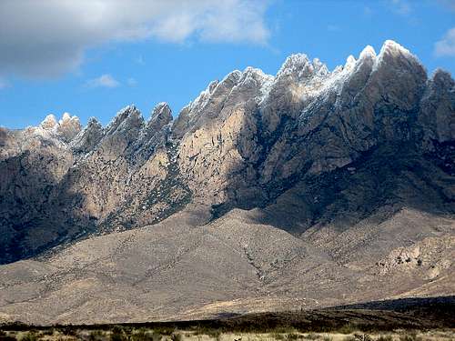 Snow on The Needles.
The Organ Mountains are located just east of Las Cruces in southern New Mexico. The name derives from the fact that a major section of the mountains bear semblance to the pipes of an organ. These mountains are volcanic in nature. To the south, a 10-mile wide gap separates the Organs from the Franklin Mountains. On the north side, San Augustin Pass (elevation 5,719 ft.), which U.S. Highway 70 runs through, divides the Organs from the San Andres Mountains.
Organ Needle, with an elevation of 8,990 feet, is the high point in the Organs as well as Dona Ana County. These steep and rugged mountains have a reputation for being largely inaccessible. Consequently, there are a limited number of hiking trails. All of the peaks, however, have been climbed over the years.
There are four primary access points (described in greater detail below), all of which are BLM-operated and accessible by 2WD: Aguirre Springs Recreation Area, Dripping Springs Natural Area, the Baylor Pass Trail (west trailhead), and the Soledad Canyon/Sierra Vista Trail.
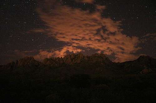 Stars over the Organs.
Hiking and Camping


AGUIRRE SPRINGS RECREATION AREA
Aguirre Springs offers the only high-country camping in the Las Cruces and El Paso areas. There are two campground areas with a total of 57 family sites and two group sites.
There are two established hiking trails. The Baylor Pass Trail is 6 miles one way and is the only maintained trail that goes across the Organ Mountains. The east trailhead at Aguirre Springs is at elevation 5,540 ft., going to 6,430 ft. at Baylor Pass, then down to 4,865 ft. at the west trailhead at Baylor Canyon Road. The pass is approx. 2.5 miles from the east trailhead. Primitive camping is permitted along these trails at no fee. The Pine Tree Trail is a 4.5 mile loop. The trail starts at an elevation of 5,700 ft. and rises to 6,880 ft. at the base of the Organ Needles.
DRIPPING SPRINGS NATURAL AREA
This is a day-use facility with four hiking trails. The Dripping Springs Trail will lead you from the visitor center east to Van Patten's Mountain Camp and old sanatorium. The La Cueva Trail goes from the visitor center to the La Cueva Rocks to the west. The Fillmore Trail intersects with the La Cueva Trail and leads north to Fillmore Canyon at the base of the mountains. The Crawford Trail run east-west and bridges the Fillmore and Dripping Springs Trails. All of the trails are short (under 2 miles one way) and easy.
BAYLOR PASS TRAIL (west trailhead)
The west trailhead is near the parking area. This 6-mile trail will take you over the Baylor Pass and to the east trailhead at the Aguirre Springs Recreation Area. The pass is approx. 3.5 miles from the west trailhead. There is a primitive campsite with a bench under a tree about 3/4 mile west of the pass. No fee for camping along this trail. Also, there is a great opportunity for a summit bag from Baylor Pass. Just head north from the top of the pass and work your way along the west side of the ridge to reach the summit of Baylor Peak (elev. 7,721'). The views are worth it.
SOLEDAD CANYON/SIERRA VISTA TRAIL
The Soledad Canyon day-use area features the Bar Canyon Trail, a 3-mile loop. The Sierra Vista Trail is a 25-mile recreation trail that runs along the west side of the Organs to the east side of the Franklin Mountains.
The Civil War In New Mexico
The Baylor Pass Trail follows roughly along the same path as that of Confederate Lieutenant Colonel John Robert Baylor, who, in the summer of 1861 during the American Civil War, led a Texas Mounted Volunteer regiment to victory over a numerically superior Union force outside of Las Cruces. The Union troops, under Major Isaac Lynde, were in retreat, abandoning a seemingly indefensible Fort Filmore due to the imminent threat of a Confederate assault. As the story goes, Union soldiers made a crucial mistake as they were destroying supplies at the fort prior to their retreat. Rather than dumping perfectly good medicinal whiskey, they opted instead to replace the water in their canteens with the whiskey. Later, as they retreated towards the San Augustin Pass, the July sun and whiskey took their toll. Baylor’s mounted Confederate force, outnumbered 600 to 200, moved across the pass that would later bear his name, and intercepted the Union force at San Augustin Spring on July 27, 1861. Baylor must have been in shock when the Union force, drunk and dehydrated, surrendered without a shot being fired.
In the Movies
The Organ Mountains made a guest appearance in the opening scene of the 1990 motion picture Young Guns II. This scene, shot along the entrance road at White Sands National Monument, shows the east side of the Organs in the distance to the southwest, along with the San Andres Mountains just north of the Organs.
Getting There
AGUIRRE SPRINGS RECREATION AREA (on east side of the Organs)
From U.S. Hwy 70, take Aguirre Springs Road south. The intersection is 1.1 miles east of the San Augustin Pass, through which Hwy 70 runs. Stay on this road until you reach the fee area and campgrounds (approx. 6 miles).
DRIPPING SPRINGS NATURAL AREA (on the west side)
From I-25 Exit 1, proceed east on University Avenue. This will turn into Dripping Springs Road as you leave Las Cruces. Stay on this road, which goes from paved to gravel, until you reach the A. B. Cox visitor center. The visitor center is approx. 10 miles from the I-25 exit.
BAYLOR PASS TRAIL (on the west side)
From U.S. Hwy 70, take the Baylor Canyon Road/NASA Road exit and proceed south on Baylor Canyon Road for approx. 2 miles until you see the small trailhead parking lot to the left. Baylor Canyon Road goes from paved to dirt shortly south of the parking area, so if you hit the dirt, you've gone too far.
SOLEDAD CANYON/SIERRA VISTA TRAIL
From I-25 Exit 1, head east on University Ave./Dripping Springs Road for 4.5 miles, head south on Soledad Canyon Road for 1 mile, where the road will turn east at a fire station. Continue east on Soledad Canyon Rd. until you see the BLM entrance gate.
GPS Coordinates for Points of Interest
Here are some GPS coordinates that might be helpful in assisting those who are not familiar with this area in getting to the various points of interest.
| Waypoint | Elevation | Latitude | Longitude |
|---|---|---|---|
| Baylor Pass | - | 32.38314 N | 106.57915 W |
| Baylor Pass Trailhead (East) | - | 32.37180 N | 106.56163 W |
| Baylor Pass Trailhead (West) | - | 32.39122 N | 106.61388 W |
| Baylor Peak | 7,721' | 32.39107 N | 106.57674 W |
| Crawford Trailhead (East) | - | 32.32579 N | 106.58414 W |
| Dripping Springs Trailhead | - | 32.32943 N | 106.59040 W |
| Fillmore Trailhead | - | 32.33538 N | 106.59734 W |
| Pine Tree Trailhead | - | 32.37009 N | 106.56012 W |
| Topp Hut | - | 32.36377 N | 106.60145 W |
| Topp Hut Road¹ | - | 32.36570 N | 106.61446 W |
¹ Intersection with Baylor Canyon Road
Red Tape
AGUIRRE SPRINGS RECREATION AREA
Open year-round. 57 family camp sites and 2 group camp sites. Group sites can be reserved ($25 reservation fee) by calling the BLM Las Cruces District Office at 505-525-4300. $3 per vehicle daily fee and $3 per night fee (if camping in established camp site). The entrance gate to Aguirre Springs is opened 8 a.m. to 8 p.m. April to October and 8 a.m. to 6 p.m. October to April. Leashed dogs are allowed on the trails.
DRIPPING SPRINGS NATURAL AREA
Open year-round except for winter holidays. Day-use only. $3 per vehicle daily fee. The entrance gate is open 8 a.m. to 7 p.m. April to September and 8 a.m. to 5 p.m. October to March. The phone number to the visitor center is 505-522-1219.
BAYLOR PASS TRAIL (west trailhead)
No fees or gates. Leashed dogs are allowed on the trail.
SOLEDAD CANYON/SIERRA VISTA TRAIL
There is an entrance gate to the Soledad Canyon day-use area. Not sure about the parking fee or gate hours (I'll find out and post later). The Soledad Canyon area and Sierra Vista trailhead are within close proximity of each other. The Sierra Vista trailhead can be accessed 24/7 as I believe it is located prior to the Soledad Canyon entance gate.
Safety

Temperatures can get high in this area and there is no reliable water source in the Organ Mountains. Make sure you have enough water. It also gets very windy in this area. Beautiful weather during the day can be very deceptive. Don't let yourself get caught in the mountains inadequately equipped as the temps plummet at night from fall to spring. Have a jacket packed just in case.
Food & Lodging
If you travel from out of the area to get to Las Cruces, make sure you take advantage of the authentic Mexican food served at the many restaurants that abound here. The Mexican food in and around Las Cruces is the best you will find outside of Mexico – it is the real deal.
I recommend the restaurant La Posta in historic Old Mesilla, just outside of Las Cruces to the west. La Posta itself is located in the same building that served as a stop on the Butterfield Overland Mail and Stagecoach Line between 1859-1861. It sits on the edge of the Mesilla Plaza, where, in 1853, the American flag was first raised following the signing of the Gadsden Purchase. The old courthouse where Billy the Kid was tried and sentenced to hang in 1881 is directly across the street from La Posta. Authentic Mexican food at a fair price in a historic atmosphere add up to a truly unique dining experience.
Las Cruces offers a wide selection of hotels and motels to fit any budget. Reference the link below for a list of hotels, motels, bed & breakfasts, and RV parks.
Las Cruces Convention & Visitors Bureau - Lodging