
-
 9922 Hits
-
 76.66% Score
-
 7 Votes
|
|
Route |
|---|---|
|
|
28.27227°N / 16.64238°W |
|
|
Download GPX » View Route on Map |
|
|
Hiking, Scrambling |
|
|
Spring, Summer, Fall, Winter |
|
|
A long day |
|
|
Hike and Scramble |
|
|
Overview
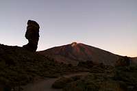
 Crossing the Lava Field to Pico del Teide Crossing the Lava Field to Pico del Teide |
Apart from the obvious cable-car there are three routes to the top of Spain's highest mountain, Pico del Teide on the island Tenerife. Of these the normal route, which heads towards the mountain from the south-east attracts about 70% of traffic. The unrelentlessly strenuous western route from Bocca Tauce across Pico Viejo, dubbed the Scree Fields from Hell, is only reasonable as a descent route. It attracts the occasional hiker but most make it only to Pico Viejo - if that far - before they have to give up. The remaining 30% of visitors use the third route, from the
Roques de Garcia towards Pico Viejo and up a lava flow to Teide.
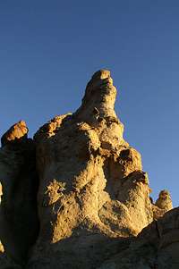
Much of the route follows a well marked path, which starts at the northern end of the Roques de Garcia Loop Trail and climbs to the slightly pronounced saddle north of Pico Viejo. From here it turns east to head across a steep and difficult lava field, where orientation can be a problem if you lose sight of the cairns marking the trail. The lava field ends right at Mirador de Pico Viejo, the western end of La Rambleta, the walkway around one third of the summit cone of Teide at some 3500m.
From La Rambleta another well marked, even cobble-paved trail leads in switchbacks to the southern end of the crater, where a steep scramble leads you along the eastern rim towards the summit of teh mountain. This last section is only open to those who have obtained a permit for the right time on the right day.
Getting There
  |
Starting point is the parking lot near the Roques de Garcia. Since this is generally overcrowded and has a history of car break-ins you can alternatively switch to the lot near the Parador Hotel, just across the road TF21 several hundred metres to the east.
There are four access roads to the Cañadas del Teide
- TF38 from Guìa de Isora (W)
- TF21 from La Orotava (N)
- TF24 (Cumbre Highway) from La Esperanza (E)
- TF21 from Granadilla (S).
Route Description
 |
- General:
- Start altitude: 2150m
- Summit altitude: 3718m
- Prevailing exposure: S
- Type: Hike and Scramble
- Protection: None
- Start altitude: 2150m
- Effort: 4 - Elevation gain: 1700m
- Power: 3 - Strenuous
- Psyche: 2 - Easy
- Difficulty: 1 - Easy
- Orientation: 2 - Some tricky sections on the lava field above Pico Viejo
 |  |  |
Starting at the Parador Hotel hike over to the parking lot at the Roques de Garcia. In the dead end, the hiking route for the loop trail starts, hike it in counterclockwise direction, heading right (north). The trail winds to the east of the fascinating rock formations until it reaches its northern end. There, right before the northernmost and highest point of the loop, the trail to Pico Viejo turns off to the right.
 |  |  |
It is a well kept trail, lined by two lines of rocks, which heads up in northerly direction, before turning north-west, heading directly for Pico Viejo. While never steep or difficult, the trail heads up a steady slope, always staying to the left (west) of a large lava field, which comes down from the Teide Summit. It negotiates sandy and rocky patches and several times passes large lava bombs, which serve as markes for the trail.
 |  |  |
About two thirds up to Pico Viejo, the trail turns northward again, heading now for the slightly pronounced saddle north of Pico Viejo. The closer you get the shallower the path until finally it winds among a large quantity of endemic Teide Gorse bushes. Up in the saddle the path from Bocca Tauce to Teide crosses, which we will follow to the very top of the island.
 |
However, make good use of your time - if it allows, I's strongly suggest visiting the large and colourful crater of Pico Viejo, 15-20 min both ways. It is one of the most beautiful and impressive places on all the Canaries and you shouldn't miss it - if you can help it.
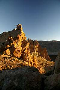
 The cinder field above Pico Viejo
Afterwards, turn east in direction of Pico del Teide. The path crosses a shallow yellow cinder field, at the uppermost end of which it heads out onto the lava field, which accompanied us all the way from the Roques de Garcia. I'd suggest you climb slowly, looking out for the many cairns which indicate the best route. Also, the lava is very sharp edged and misstepping you might actually cut your shins.
 |  |  |
In general, the path heads directly for Pan de Azucar, Teide's summit cone, but it switches back and forth a lot. Try to stay on the tops of the lava ridges. Getting out of the depressions is rather difficult, especially as the angle of the lava slope is close to 45°. Finally - if you don't miss out on the trail - you'll reach La Rambleta, the walkway around a third of Pan de Azucar, in the lookout spot Mirador de Pico Viejo. It is famous for the view of the Pico Viejo Crater with the islands La Gomera and El Hierro hovering above.
 |
Again, if time allows, make sure to walk La Rambleta all the way to its other end at Mirador de Fortaleza. It is the only more or less flat section of the route and offers great views of the Cañadas del Teide and the Anaga Peninsula. The proper final climb of Pan de Azucar, however, starts near the restauurant shelter north of the cable-car, marked by a ranger, who will check your permit for the right time and day.
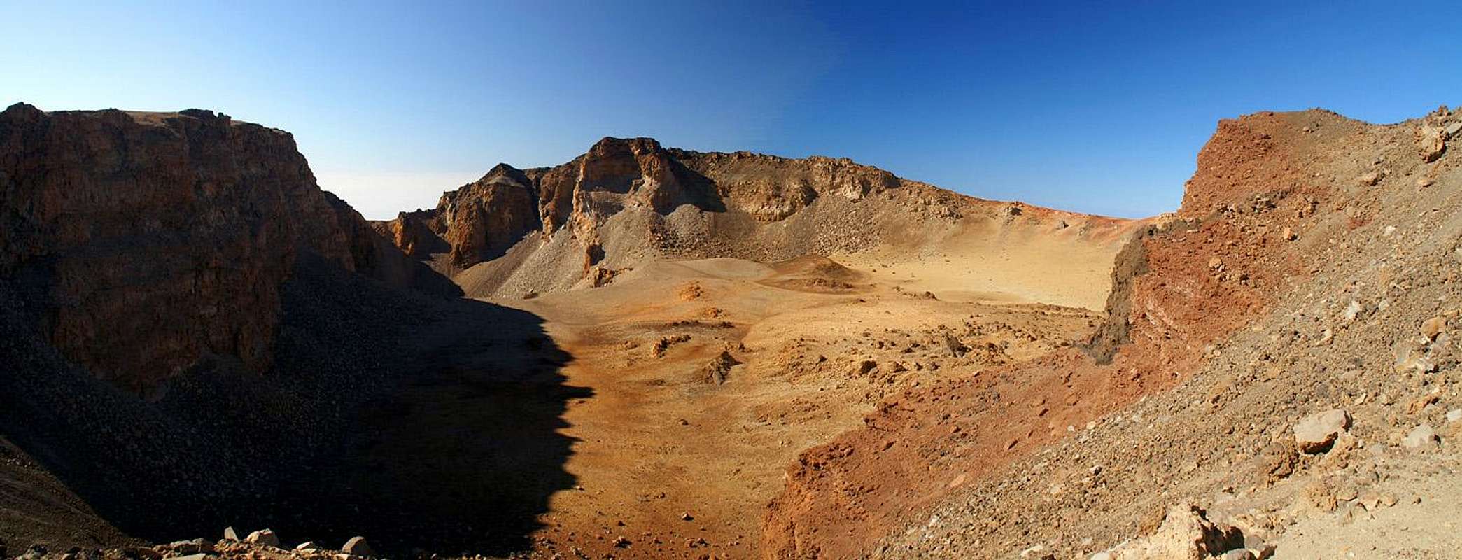
 Las Cañadas del Teide
 Here the steepest part of the climb starts. First the route heads back north-west behind the cable-car housing. The path is well marked, even cobbled in several sections. At the far end the path abruptly turns northward again and now heads in staircase-like switchbacks to the lowest spot of the summit crater. Most of the hikers, who came up in the cable-car will struggle a lot with the lack of air here.
 |  |  |
The crater itself is rather disappointing after the Pico Viejo one. Small and rather white-greyish instead of colourful, it looks like a rubble-filled depression. The summit path now heads up its eastern rim very steeply, passing by several holes out of which fumaroles, warm, sulphorous vapouurs, rise. The largest of these is right to the east of the summit, somewhat marring the otherwise wonderful summit experience.
Essential Gear
Generally you'll need hiking gear. Hiking boots are mandatory for the lava field traverse - sneaker's soles are just too thin and don't protect your ancles. Bring a lot of water - 3l per person was ok for us.You might want to bring Aspirins - or stronger stuff. Sleeping at sea level, driving up to 2000m in an hour, then climbing to 3720m in another 4 will be tough on your body. I've been on Teide three times - twice using this route for descent - and each time splitting headaches developed right after summitting. For me no amount of pain killer would help as long as I was still struggling along the paths, also due to the very intense light up there. Later, going down by car, everything fell back to normal.