
hi all..
has anyone been up to eagle lake in tahoe this season?? Any clues on the best places to find some ice around there would be sweet...
Also my stoner partner has left me high and dry, i wont go into it. But if any of you nice summitposters are up for a bit of pre xmas ice or mixed around tahoe drop me a line.
415 713 8104...
cheers
PR
eagle lake ice????
11 posts
Page 1 of 1

-

Fire4x4 - Posts: 111
- Joined: Tue Jan 06, 2009 2:28 am
- Thanked: 5 times in 3 posts
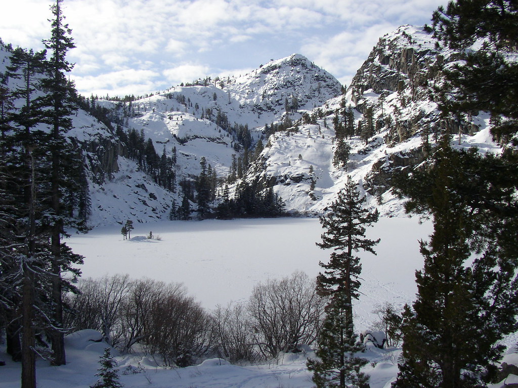
I have hiked in to sunny falls twice sense November. The first weekend was the 29th of Nov and I could climb one line. Went back Dec. 9th and there was enough to put screws in for an anchor toTR it with multiply lines. The bolted mixed line to the left was not even close to being in. Nothing on the cliffs on the south side of the canyon before sunny falls as well. All that was 2 weeks ago and with the way the weather has been, I would say it has only gotten better. The approach was a PITA!!! Breaking trail in 2+ feet of powder the entire way. The lake was frozen at that time and im guessing it still is. 89 was closed due to Avy hazard so It took about 3+ hours to hike in with snowshoes and we were not going slow. Ive got pictures if you want to see... No clue on how to post them up but would be more then willing to e-mail them to someone and they could post them.
-

rhyang - Posts: 8960
- Joined: Wed Apr 28, 2004 8:55 pm
- Thanked: 59 times in 38 posts
Curious to know how things fared after the warm temps last week 
If you have pics, you can upload them to SP using the 'Create Page' link at the top left near 'Your Profile'. Click 'Image' and then Continue. I know you've done this before
Once you get the images on SP, you can post pics to forum threads by clicking the Img button. But first, open your image in another browser tab (or window) and select one of the sizes, such as 'Orig' or 'Med' and copy the URL from the browser window.
Then click Img in the forum page, paste in the URL you copied, and click Img again. This should result in bbCode like this -
eg.

If you get around to attaching them to the Eagle Creek Canyon page somewhere (for example, Sunny Falls), that would be great too (but I can if it looks too hard).
If you have pics, you can upload them to SP using the 'Create Page' link at the top left near 'Your Profile'. Click 'Image' and then Continue. I know you've done this before
Once you get the images on SP, you can post pics to forum threads by clicking the Img button. But first, open your image in another browser tab (or window) and select one of the sizes, such as 'Orig' or 'Med' and copy the URL from the browser window.
Then click Img in the forum page, paste in the URL you copied, and click Img again. This should result in bbCode like this -
- Code: Select all
[img]http://c0278592.cdn.cloudfiles.rackspacecloud.com/original/491183.jpg[/img]
eg.
If you get around to attaching them to the Eagle Creek Canyon page somewhere (for example, Sunny Falls), that would be great too (but I can if it looks too hard).

-
rhyang - Posts: 8960
- Joined: Wed Apr 28, 2004 8:55 pm
- Thanked: 59 times in 38 posts
Went for a stroll up there yesterday. I didn't see anything in on the south side of the canyon except some thin slabs.
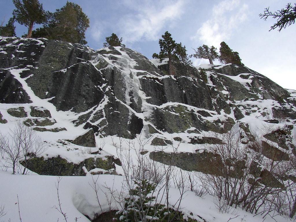
Cutty Sark - not there yet

Sunny Falls' right side looked climbable, though somewhat hacked out in places. Left side looked to have some hanging daggers.


The usual walk off/up to the left looked to be thin with lots of running water underneath. Walking up the slope to the right and then traversing left above the cliff worked out better.

The lake looked to be frozen and people were snowshoeing out on it. A few inches had fallen since the last steps .. a new dump of 6-12" is due by the end of today.
Full set here.
Cutty Sark - not there yet
Sunny Falls' right side looked climbable, though somewhat hacked out in places. Left side looked to have some hanging daggers.
The usual walk off/up to the left looked to be thin with lots of running water underneath. Walking up the slope to the right and then traversing left above the cliff worked out better.
The lake looked to be frozen and people were snowshoeing out on it. A few inches had fallen since the last steps .. a new dump of 6-12" is due by the end of today.
Full set here.

-
rhyang - Posts: 8960
- Joined: Wed Apr 28, 2004 8:55 pm
- Thanked: 59 times in 38 posts
See the Sunny Falls page -- walk up to the left or right. The left side looked a bit sketchy last time I was there, but may be better with more snow, so I went up the right (there were also tracks).
Also be careful to check the Central Sierra Avalanche Advisory beforehand .. someone was killed in the canyon (near Maggie's Peak I think) a year or two ago.
Also be careful to check the Central Sierra Avalanche Advisory beforehand .. someone was killed in the canyon (near Maggie's Peak I think) a year or two ago.
11 posts
Page 1 of 1
-
- Related topics
- Replies
- Views
- Last post
-
- eagle lake ice--its out there
by dr. jay » Fri Feb 12, 2010 6:37 am - 2 Replies
- 901 Views
- Last post by rhyang

Fri Feb 12, 2010 3:53 pm
- eagle lake ice--its out there
-
- Eagle Creek Canyon ice conditions?
by Diggler » Tue Feb 23, 2010 12:01 am - 0 Replies
- 1612 Views
- Last post by Diggler
Tue Feb 23, 2010 12:01 am
- Eagle Creek Canyon ice conditions?
-
- June Lake ice
by mtndonkey » Fri Jan 27, 2012 4:44 am - 8 Replies
- 2670 Views
- Last post by Denjem
Tue Feb 28, 2012 10:55 pm
- June Lake ice
-
- June Lake Ice
by DanielWade » Sun Feb 07, 2010 7:00 am - 4 Replies
- 1651 Views
- Last post by Dragger
Mon Feb 08, 2010 11:42 pm
- June Lake Ice
-
- Castle Lake "ice"/snow beta (Shasta)
") by Shane Rathbun » Thu Feb 14, 2013 2:01 am
by Shane Rathbun » Thu Feb 14, 2013 2:01 am
- 1 Replies
- 1645 Views
- Last post by Shane Rathbun
Tue Feb 26, 2013 2:35 am
- Castle Lake "ice"/snow beta (Shasta)
Who is online
Users browsing this forum: No registered users and 0 guests