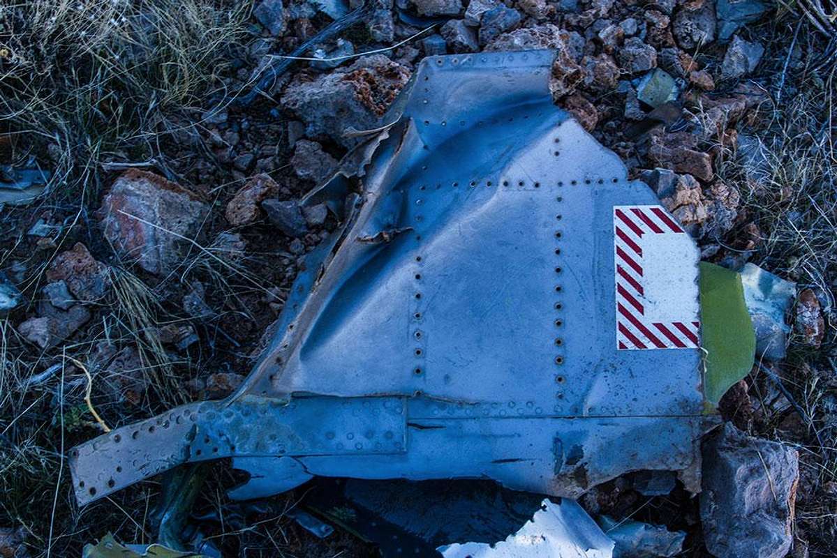
California Ridge crash site
4 posts
Page 1 of 1
-

goofball - Posts: 80
- Joined: Fri May 16, 2008 1:48 am
- Thanked: 5 times in 4 posts
California Ridge crash site
Traversed California Ridge today (between I-15 and Valley of Fire) and found a lot of scattered but mostly very small debris up high about 100' beneath the crest, ~2 miles (?) north of where the road to Weiser Mine cuts thru it. Unable to find any info online, does anyone happen to know anything about this site ?
-

boyblue - Posts: 191
- Joined: Sat Feb 15, 2003 9:30 am
- Thanked: 111 times in 66 posts
Re: California Ridge crash site
I was intrigued by your post and did a little Googling and found the following site:
https://maps.google.com/maps/ms?ie=UTF8&t=h&oe=UTF8&msa=0&msid=114943749473014216758.000439e4acb99bb30cb9f
There is a crash site marked on the map about 4 miles east of California Ridge that may very well be misplaced from where you found actual debris. Almost no information about this military mishap, though. Apparently, they're not in the habit of holding press conferences about every single test flight that goes awry. (Hope the pilot was able to eject to safety.)
-

Jesus Malverde - Posts: 380
- Joined: Wed Nov 14, 2001 1:17 pm
- Thanked: 140 times in 90 posts
Re: California Ridge crash site
goofball,
Not sure this helps, but did you check these sites?
http://www.aircraftwrecks.com/
http://www.av.qnet.com/~carcomm/wrecks.htm
Best,
JM
Not sure this helps, but did you check these sites?
http://www.aircraftwrecks.com/
http://www.av.qnet.com/~carcomm/wrecks.htm
Best,
JM
-
goofball - Posts: 80
- Joined: Fri May 16, 2008 1:48 am
- Thanked: 5 times in 4 posts
Re: California Ridge crash site
thank you guys.
jesus - i had seen that 1st site you reference but found no info there. that 2nd site i see nothing either.
boyblue - i saw that google map too, and it seems reasonable it could be associated with what i found. maybe what i saw on the ridge is from an airborne break up, while the map pinpoints the main impact site ? was hoping to find some more definitive record tho. but like u said, military probably doesn't want press on every mishap.
been googling insignia as wel to try and find what that partial logo may indicate, but no luck yet.
thanks again guys !
4 posts
Page 1 of 1
-
- Related topics
- Replies
- Views
- Last post
-
- Tragic Plane Crash near Flatiron
by lcarreau » Thu Nov 24, 2011 4:02 pm - 6 Replies
- 6977 Views
- Last post by lcarreau

Tue Nov 29, 2011 12:36 am
- Tragic Plane Crash near Flatiron
-
- Helicopter crash on Charleston; curious science
by MoapaPk » Tue Sep 29, 2009 8:25 am - 13 Replies
- 3447 Views
- Last post by MoapaPk
Fri Oct 02, 2009 4:35 pm
- Helicopter crash on Charleston; curious science
-
- Hondo Ridge Distances?
by Katlinbr » Sat Aug 16, 2014 9:10 pm - 2 Replies
- 4281 Views
- Last post by jdzaharia
Wed Aug 27, 2014 5:33 pm
- Hondo Ridge Distances?
-
- North ridge of Humphrey's Peak
by ChristopherFranklin » Thu Aug 23, 2012 4:32 am - 9 Replies
- 3947 Views
- Last post by lcarreau
Sun Sep 23, 2012 3:45 am
- North ridge of Humphrey's Peak
Who is online
Users browsing this forum: No registered users and 0 guests