Hi summitpost. This is my first post, I’m new to the site! And my question is, anyone been up to Whitney in the last week? I am looking at East Buttress for this coming weekend and wondering about the conditions. I think the MR has snow in it based on a post on the summit log, so thinking ice axe and crampon for this. Any one try it recently? Sound like the right idea?
Thanks!
Whitney MR Conditions
5 posts
Page 1 of 1
-

fedak - Posts: 710
- Joined: Tue Jun 24, 2003 5:28 pm
- Thanked: 106 times in 85 posts
Re: Whitney MR Conditions
Welcome aboard- and let me redirect you elsewhere 
The Whitney Portal Store message board is your best bet for current Whitney conditions:
http://www.whitneyportalstore.com/forum ... d=1&page=1
The Whitney Portal Store message board is your best bet for current Whitney conditions:
http://www.whitneyportalstore.com/forum ... d=1&page=1
____________________________________________________________________________________________________________________________
http://www.fedak.net/backcountry.html
http://www.fedak.net/backcountry.html
-

Kimmy - Posts: 2
- Joined: Tue Jul 05, 2011 10:07 pm
- Thanked: 0 time in 0 post
Re: Whitney MR Conditions
Thanks! I looked there but saw no recent updates on the forum. Perhaps I'll call the ranger.
-

finckster - Posts: 29
- Joined: Tue Jun 30, 2009 5:12 am
- Thanked: 4 times in 4 posts
Re: Whitney MR Conditions
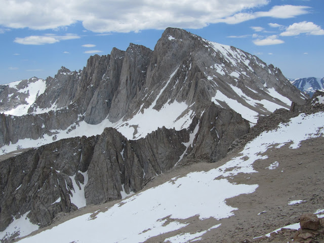
Wasn't on the MR, but got some shots of it from the Russell/Carillon area on Sunday. Snow was very soft everywhere.
-

Kurt Wedberg - Posts: 294
- Joined: Sat Jun 03, 2006 7:17 am
- Thanked: 23 times in 14 posts
Re: Whitney MR Conditions
I just got back from a trip up the Mountaineer's Route July 9-10. Here's an update:
Creek crossings: Creeks are the fullest I can ever remember seeing. Rocks are covered that we normally use at creek crossings. The first creek crossing is also made more difficult because all the big branches we used to hold on to have been cut. The second one (just below the E Ledges) is so full you’re guaranteed to get wet from the waterfall. All the logs are wet and slick. There’s a tree that fell in between the two sections of the section of the creek. As you enter the second section of the creek all the rocks are submerged. There are some branches you can use to sneak across on. The 3rd crossing at LBSL is full but you can get across the log on the lower side.
E-Ledges: They’re all good. The only thing that’s changed is a tree fell into one of the slots of rock we normally walk through. It requires a big step up or mantle move.
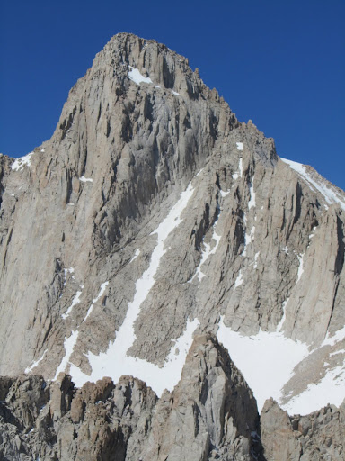
Snow: There’s a couple patches just above UBSL but they won’t pose any problem even if it’s firm and hard in the middle of the night. We put on crampons at the hill just below Iceberg Lake. It’s just over ¾ full of snow. It’ll then be bare for a short section but we left the spikes on. There’s snow up to about ¾ of the way up the Mountaineer’s Chute. It’s firm and is starting to form sun cups. There isn’t a great kicked in trail although there are some tracks that were useful. Where the snow stops you could leave crampons and ice axes there if you wanted to. Above the notch there are a couple patches of snow but they can be avoided. There’s ice forming from melt freeze cycles but it shouldn’t pose a problem. You’ll be able to avoid it or step through it. There’s a snow patch at the base of the notch that’ll help you step into the route. We used the summer route on rock.
Here’s a link to the pictures I took. There are photos of the creek crossings and conditions of various parts of the route: Mt. Whitney Mountaineer's Route July 9-10, 2011.
Here are a few selected photos:

The first half of the 2nd creek crossing just below the Ebersbacher Ledges.

Waterfall on the 2nd half of the 2nd creek crossing.

The slope just below Iceberg Lake.

High in the Mountaineer's Chute.

The final 400+ feet of the Mountaineer's Route.
Creek crossings: Creeks are the fullest I can ever remember seeing. Rocks are covered that we normally use at creek crossings. The first creek crossing is also made more difficult because all the big branches we used to hold on to have been cut. The second one (just below the E Ledges) is so full you’re guaranteed to get wet from the waterfall. All the logs are wet and slick. There’s a tree that fell in between the two sections of the section of the creek. As you enter the second section of the creek all the rocks are submerged. There are some branches you can use to sneak across on. The 3rd crossing at LBSL is full but you can get across the log on the lower side.
E-Ledges: They’re all good. The only thing that’s changed is a tree fell into one of the slots of rock we normally walk through. It requires a big step up or mantle move.
Snow: There’s a couple patches just above UBSL but they won’t pose any problem even if it’s firm and hard in the middle of the night. We put on crampons at the hill just below Iceberg Lake. It’s just over ¾ full of snow. It’ll then be bare for a short section but we left the spikes on. There’s snow up to about ¾ of the way up the Mountaineer’s Chute. It’s firm and is starting to form sun cups. There isn’t a great kicked in trail although there are some tracks that were useful. Where the snow stops you could leave crampons and ice axes there if you wanted to. Above the notch there are a couple patches of snow but they can be avoided. There’s ice forming from melt freeze cycles but it shouldn’t pose a problem. You’ll be able to avoid it or step through it. There’s a snow patch at the base of the notch that’ll help you step into the route. We used the summer route on rock.
Here’s a link to the pictures I took. There are photos of the creek crossings and conditions of various parts of the route: Mt. Whitney Mountaineer's Route July 9-10, 2011.
Here are a few selected photos:
The first half of the 2nd creek crossing just below the Ebersbacher Ledges.
Waterfall on the 2nd half of the 2nd creek crossing.
The slope just below Iceberg Lake.
High in the Mountaineer's Chute.
The final 400+ feet of the Mountaineer's Route.
5 posts
Page 1 of 1
-
- Related topics
- Replies
- Views
- Last post
-
- Whitney climbing conditions?
by Snowball » Thu Jan 07, 2010 8:37 am - 2 Replies
- 1384 Views
- Last post by Snowball

Thu Jan 07, 2010 11:54 pm
- Whitney climbing conditions?
-
- Mt. Whitney conditions
by vidclimber » Sun Feb 21, 2010 6:48 pm - 9 Replies
- 5323 Views
- Last post by Misha
Wed Mar 17, 2010 3:32 am
- Mt. Whitney conditions
-
- Whitney Mountaineer's Route Conditions
by ChugachMan » Thu Apr 05, 2012 9:02 pm - 2 Replies
- 2594 Views
- Last post by Holsti97
Fri Apr 06, 2012 4:32 am
- Whitney Mountaineer's Route Conditions
-
- Mt Whitney - Chute conditions
by juggernaut » Tue May 22, 2012 7:17 am - 1 Replies
- 1520 Views
- Last post by saltlick
Tue May 22, 2012 10:20 pm
- Mt Whitney - Chute conditions
-
- Whitney Portal road conditions
by twicken2 » Thu Nov 24, 2011 7:23 pm - 2 Replies
- 3219 Views
- Last post by TheNobleSunfish
Fri Dec 02, 2011 7:50 pm
- Whitney Portal road conditions
Who is online
Users browsing this forum: No registered users and 0 guests