Toggle navigation
Mountains
Routes
Images
Trip Reports
Forum
What's New
People
Areas & Ranges
Articles
Trailheads
Canyons
Huts & Campgrounds
Albums
Logistical Centers
Fact Sheets
Lists
Custom Objects
Gear
Plans & Partners
WELCOME TO SUMMITPOST
SIGN IN
REGISTER
From Towne Pass
Additional Parents
Image
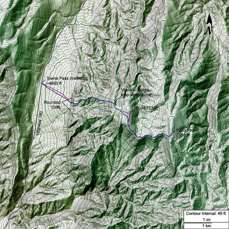
Pinto Peak from Towne Pass
View High-Resolution Image
Pinto Peak from Towne Pass
This topo image was created using a program I wrote. It must be viewed full-size in order to see the information. The magenta and blue traces are the paths I took for ascent and descent, respectively.
« PREV
NEXT »
Day Hiker
on
Nov 2, 2010 5:50 pm
Comments & voting
Other parents
Lat/Lon:
36.38373°N / 117.22647°W
Image Type(s):
Hiking
Image ID:
676372
1371 Hits
74.01
% Score
4
Votes
Log in to vote
Comments
No comments posted yet.
to post!
Don't have an account?
From Towne Pass
(Route)
You are at
the First
Image
Viewing
#1 of 1
GALLERY
You are at
the Last
Image
Day Hiker's Image Gallery
« PREV
Viewing
#113 of 121
GALLERY
NEXT »
×
You need to login in order to vote!
User Name
Password
Remember me
Forgot your password?
Log me out when I close my browser.
Keep me logged in all the time.
sign in as a user
Don't have an account?
Register now for FREE
Rating available
Suggested routes for you
People who climb the same things as you
Comments Available
Create Albums
Register Here


