
|
|
Route |
|---|---|
|
|
36.38373°N / 117.22647°W |
|
|
Download GPX » View Route on Map |
|
|
Hiking |
|
|
Spring, Fall, Winter |
|
|
Half a day |
|
|
Class-2 |
|
|
Stats
Distance: 8.2 miles round-trip.Elevation Gain: 3050 feet total, round-trip.
Time: 4-6 hours.
Getting There
In Death Valley National Park, take California Highway 190 to its highpoint in the Panamint Mountains -- Towne Pass. There is a large gravel parking area on the west side of the road, just north of the "Towne Pass" sign.Route Description
The route to Pinto Peak from Towne Pass is not incredibly complicated. For those that prefer to find their own way, skip to the text marked with the * below.Viewing the hills east of Towne Pass, a moderate and broken band of rounded cliffs is apparent where the bottom of the slope meets the plain. There are surely several ways to pass this minor obstacle, but I will describe the way I took, which turned out to be a rather direct route and did not exceed class-2.
From the parking area at Towne Pass, cross the road and hike approximately east-southeast across the scrub-covered plain to a weakness in the cliffs shown in the photo.
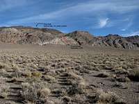
When you reach the point indicated by the bottom of the red mark, you will be at the base of a steep rocky hillside. From this point, a route up this 250-foot hillside is not too difficult to follow. With a bit of easy route-finding, the hillside can be gained without exceeding class-2 terrain.
From the top of the rocky hillside, hike east-northeast up the slope. Head for a rocky outcrop, and from there, follow what will become an obvious but rounded ridge.
You will pass some old National Park boundary signs around the 6100-foot level. As the ridge is ascended, the views open up, revealing the high peaks of the Sierra Nevada to the west.
At around 6500 feet, the distinct ridge will end, and the route continues east up a steep slope. At the top of this slope is a boulderfield of dark volcanic rock. From here, turn right and head southeast and then east up to the hill that forms the eastern skyline. This hill is marked by the label "Point 7239ft" in the topo image.
Once reaching this hill, turn right again and head south and then east, following the ridgeline across a couple of saddles and then finally up to the summit of Pinto Peak.
* Welcome to the summit of Pinto Peak and its awesome views. The higher Panamints including Telescope Peak dominate the south-southeast. To the northwest are the Inyo Mountains. And as is typical for Panamint peaks, there are great views of the Sierra Nevada (west and northwest), the Spring Mountains (east), and even the White Mountains (north-northwest).
On the summit, you will find a "PINTO" benchmark, and next to a small rock outcrop, there is a register box with some dates going back to the early 1960s.
Essential Gear
Ten essentials. The route has no water or shade, so bring lots of water in the summer. For the small rocks and shrubs, some light hiking boots and desert gaiters would be useful. Long pants would help protect against the brushy areas.In winter, these elevations can have snow, so the appropriate boots would be necessary in that case.