The disclaimer uses a headline (bolded & highlighted)plus, changing the font from black to red.
This page is for my personal use on html writing. I'm just learning how to use it. There may be pictures that do not belong to me on this page. I'm not trying to steal them. I am just copying html codes from some of the forums and saving to my practice page to help me on future reports
The code below is used for 2 rows of 2 pictures (clickable).
The following moves table to the right and changed border color. Note, can use numbers or type out the actual color to change the border color.
Changed the 2 rows of two from small to medium.
The following puts pictures from top to bottom along the right side and the text to the left. The include picture title.
![Comanche Trail]() Lower Comanche Trail
Lower Comanche Trail![Avy Chute]() Avalanche Field
Avalanche Field![Glimpse of Horn Peak]() Horn Peak In The Distance
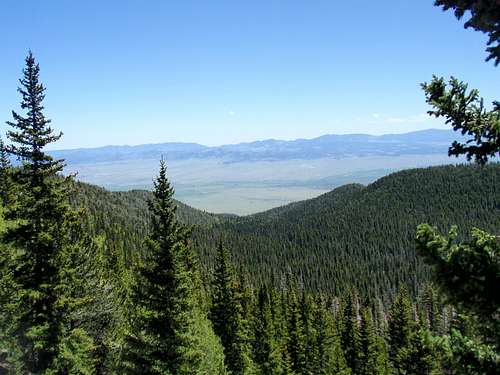
Horn Peak In The Distance![Wet Mountain Valley]() Wet Mountain Valley
Wet Mountain ValleySo, now that you know a little bit about it, let’s go take the hike and see what it looks like.
I’d been waiting for months to finally get out and do a hike avoiding the snowfields that seem like they just don’t want to leave this year. My friend and I have a weeklong hike planned in the Sangres coming up in little over a week and I wanted to see if the passes were passable, so I decided on doing this loop hike. I knew that if I was able to cross the Phantom Terrace, the rest of the range should be passable as well.
The day was gorgeous and sunny. Not a cloud in the sky. Seems to me, the last time I saw a day like this was in September, almost a year ago. Winters can be long in Colorado.
I parked at the trailhead and decided on heading up the Comanche side. Crossed the Rainbow trail and signed in at the trailhead about 15 minutes later. Noticed there were two groups of two ahead of me. This would be considered heavy traffic for trails around Westcliffe. All the more reason I love living here. I started the ascent and hit the first open area where I could see quite a distance away. The forest was brightly lit with aspen.
After following the trail westerly for a couple of miles, it makes an abrupt turn due south past an old avalanche field and begins to climb a series of several fairly short switchbacks. After the switchbacks, you reach a saddle where you get a clear view of the valley to the south that leads to Comanche Lakes as well as a glimpse of the upper tip of Horn Peak.
Once you pass the saddle, the trail heads westerly and narrows quit a bit. I cross a couple of large rock slides and continue climbing. Seems like, any place you go hike you’re going to pass rock fields. I guess, that’s why they call em The Rocky Mountains, ya think? About a mile and a half past the saddle I reached the basin and see the first bright blue lake. Continue climbing a short distance and the second lake appears. Up ahead, directly in front of me is Comanche Peak. And finally, to the right of Comanche Peak is Comanche Pass.
After passing the lakes, the trail begins to switchback and rises towards the pass. In the distance, I can see large snowfields and wonder how much difficulty I’m going to have in circumventing them. There’s a large field at the saddle as well. I continue to climb and find that there’s nothing to it. Pass 3 hikers sliding down a couple of the snowfields on their butts and begin to wish I was heading down, instead of climbing up. Just so I could do a slide myself.
Just before reaching Comanche Pass, I see a rock outcropping. Below it, sits a small wooden cross. I climb down and do a little exploring, trying to see if it has any words on it. At first, I see nothing and notice that it’s mounted to some sort of circular bottom. I’m able to turn it and a small picture of a young boy appears. All sorts of thoughts come to mind. I wonder what had happened here. Knowing that it had to be a place of great sadness for someone. Whose child is it? How long has the cross been here? Also, realizing that if I had started the loop hike on the Venable side, I probably would have walked past it without ever seeing it. I snapped a picture of the memorial and climbed a few more feet, reaching the top of the pass. The beauty of Gods creation appears in all directions. Standing on top of the world I see for miles and miles in all directions.
The table below is used for 1 row of four.
For 2 rows of four.
The following code is an alternate code used for 3 thumbnail (no titles) photos with borders. Clickable to page.
No borders on this.
this explains some of the coding on the section just above: Notice the ".html" on the end? That's the address (actually, one of several) of the web page that holds the photo (together with voting, comments, and links to all the albums, routes, etc where the photo is attached.) One of the numbers (486293) is the ID of the photo itself, the other (486293) is the ID of the object (a Route, in this case) that is listed first in the right-hand side, and also determines what the "breadcrumb trail" at upper left looks like.
In effect, the second number records the context - how you got to this page. It's actually optional. What's going on is that SP writes its HTML files on-the-fly every time your browser requests one. SP creates basically the same page with slight variations for each of a few different URLs......................
the following two sections are a question why something isnt centering (first section)-The second is supposed to be the correction.
Got the medium photos centered now though I cannot get the small photos to center above and below the medium centered photos, any ideas?
![Mountains Nth West of Zagham]() Magnificent unexplored mountains
Magnificent unexplored mountains![Mt Zagham]() Mt Zagham 4150metres
Mt Zagham 4150metres
![Mountain Ranges beyond Mt Zagham]() Mountain ranges to the North of Mt Zagham which are very inaccessible Mountain ranges to the North of Mt Zagham which are very inaccessible |
![Mt Zagham showing waterfalls]() Waterfalls of Mt Zagham post heavy rains Waterfalls of Mt Zagham post heavy rains |
![Eastern Flank and snowfields of Carstensz Pyramid (Puncak Jaya) region]() Eastern Flank of Mt Zagham with snowfields of Puncak Jaya in the background Eastern Flank of Mt Zagham with snowfields of Puncak Jaya in the background |
This should help...
![Mountain Ranges beyond Mt Zagham]() Mountain ranges to the North of Mt Zagham which are very inaccessible Mountain ranges to the North of Mt Zagham which are very inaccessible |
![Mt Zagham showing waterfalls]() Waterfalls of Mt Zagham post heavy rains Waterfalls of Mt Zagham post heavy rains |
![Eastern Flank and snowfields of Carstensz Pyramid (Puncak Jaya) region]() Eastern Flank of Mt Zagham with snowfields of Puncak Jaya in the background Eastern Flank of Mt Zagham with snowfields of Puncak Jaya in the background |

 1196 Hits
 0% Score
 0 Votes


 West
West North West
 West
West Magnificent unexplored mountains
 Mt Zagham 4150metres
 Mountain ranges to the North of Mt Zagham which are very inaccessible
  Waterfalls of Mt Zagham post heavy rains
 Eastern Flank of Mt Zagham with snowfields of Puncak Jaya in the background