The Character
Long and joyful, easy ski tour. Only in very bad conditions the top section can be harder. Good 3 hours for ascent (1225 m), 1 hour (or less) for the downhill.
Getting There
See the main page how to get to Preber See, 1514 m.
Route Description
![Preber Map]() Preber map
Preber mapFrom the parking place at Preber See take the mountain road which ascends through the woods towards the north. It is also marked, actually the marked path takes shortcuts directly through the light woods. In some 30 minutes you reach Prodingerhuette, 1734 m, and in another 30 minutes Preberhalterhuette, 1862 m. There the terrain opens and you can already see all the broad slopes till the fore-summit of Preber.
![Preber Ski Ascent]() Preber ski ascent
Preber ski ascent![Preber South Slopes]() Preber south slopes
Preber south slopesFrom the hut the ski trail usually continues a bit towards the right, towards the broad ravine, but soon starts tending left again and so ascens on the southern ridge of Preber. The slopes are gentle, so you keep ascending directly up - no turns, no rest for your heart. You quickly gain altitude, but the ascent is also quite long and tiresome. The last 200 meters below the fore-summit are a bit more steep. You do them in a few turns with skis. If the snow is hard or even icy, take here some care not to slide down! On the fore-summit there are a few rocks and some skiers leave skis there. But you have only some 50 more meters to go and the summit slope is also appropriate for skiing. So, proceed to the big cross on the main summit.
You ski down in the direction of ascent. Depending on conditions, you can also choose slopes, inclined more towards the SE or SW.
Essential Gear
Ordinary tour skiing equipment. In hard snow 'ski crampons' are helpful.

 3239 Hits
 71.06% Score
 1 Votes
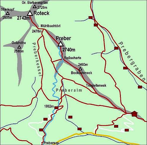 Preber map
 Preber ski ascent
 Preber south slopes