


-
 3951 Hits
-
 81.84% Score
-
 14 Votes
|
|
Mountain/Rock |
|---|---|
|
|
45.58500°N / 7.63050°E |
|
|
Hiking, Mountaineering, Trad Climbing |
|
|
Summer, Fall |
|
|
8629 ft / 2630 m |
|
|
Note
|
La montagna chiama i suoi figli, ed essi rispondono fedelmente al suo appello… Osvaldo Cardellina, Diario alpinistico, 1964-65 Page texts: @ OsvaldoCardellina "Osva", passed away on May 2, 2022. Page owners: Christian Cardellina e Osvaldo Cardellina. Any updates from September 12, 2022: Antonio Giani, page administrator, friend and climbing companion. Testi della pagina: @ OsvaldoCardellina "Osva", scomparso il 2 maggio 2022. Proprietari pagina: Christian Cardellina e Osvaldo Cardellina. Eventuali aggiornamenti dal 12 settembre 2022: Antonio Giani, amministratore della pagina, amico e compagno di salite. |
Overview
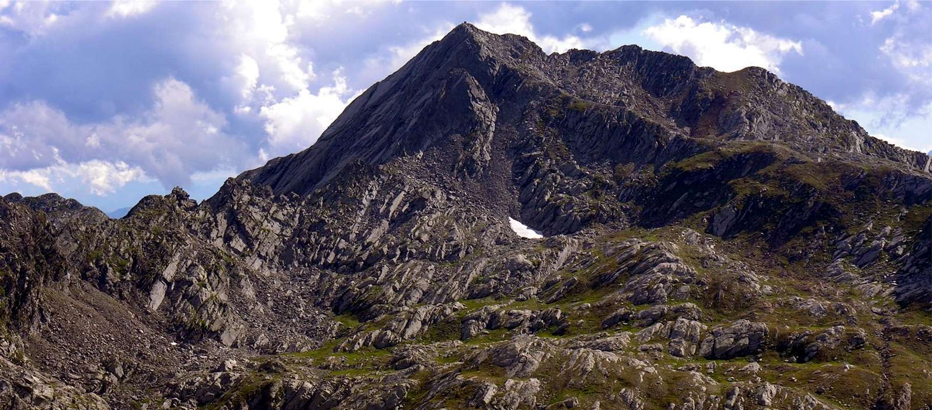
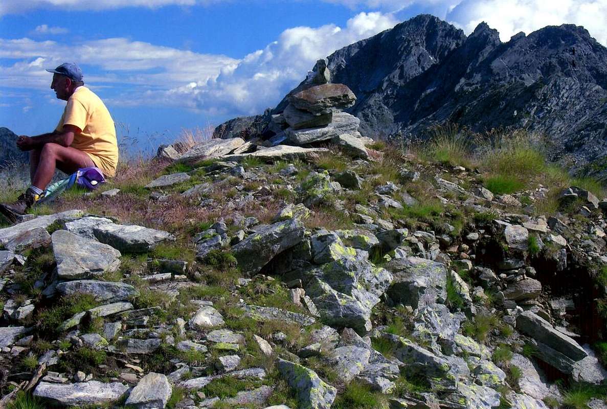
This Summit is part of the Group of Mount Marzo (2.756m), located between the Valleys of Champorcher and Pianprato Soana and Chiusella in Piedmont. In fact the group membership is, though less known, that of Monte dei Corni (2.779m), this being the highest Summit in this part of the watershed with the Aosta Valley and immediately to the East of the previous year. From this last down towards the North a secondary buttress act to separate the Valley of Manda or Amanda to the East by the West to that of Legna. After the Fricolla Pass (2.542m) (*** connecting the two in their highest part through Bruillet Col (2.450m), but in reality is divided from the next Vallon of Brenve) stands up to the crest of the same name Point (2.676m) above Lake Cornuto (2.450m; Horned); then the ridge continues, sinuous, forming the Ridge Chenessy (2.756m) that "serrated" form a series of at least four elevations (2.616m, 2.665m, 2.650m, 2.616m) before reaching the Punta Chenessy (2.630m ). This, call B&V 1896, page 26 of Costa Canessi with altitude 2.631 meters, even if only slightly less high stands out more as isolated. At his feet to the East lies the small lake of the same name (2.383m), while on the opposite side down with rocky cliffs-grassy above Alpe Chenessy (2.051m) in the adjoining Vallon of the Legna (Wood). A ridge facing North-northeast continues steeply towards the Hills of Manda (around 2.390 meters) and Detrà (about 2.350 meters), separated by a small Summit 2.414 meters. Besides the watershed continues further Northeast forming the rounded Mont Giavin (2.431m), Col de Creuset (2.121m) to end with the Mont Digny (2.145m) above the Crest Lutta and small Villages Frassiney and Trambesere, now on the bottom of the valley. Mountains are little known and even less popular, if not by the locals or somewhere fancier of rarities, as evidenced by the poor mound found on the summit (see photo), even though the reality "Guide of the Western Alps", same page, noted: "... highlight (trigonometric signal) of the dividing Range between the valleys of the Legna and Amanda ..."; sign that more than 100 years before it was already known and frequented. At least from Topografi State Piedmont-Sardinian, but also demonstrating that "King Toio" was jealous of his possessions and controlled them better than they do today. However remain Vallons most frequented by Fishermen that the Mountaineers or Hikers, and perhaps especially because of the long and exhausting approaches. This vast area, which stretches to the East towards the Canavese and Ivrea and Southeast to the Po Valley and the City of Torino, constitutes the extreme offshoots of the Gran Paradiso after the last major Summits of the Tower of Lavina and the Rosa dei Banchi, for which it still belongs to the Mountain range of Graian from here dates back to the Mont Blanc. From this you can enjoy pleasant views of the surroundings from Monte Marzo, but also on the number of small seeds Summits abandoned that stretch towards the Lower Valley. Frontally instead, taking advantage of the Chain from Mont Glacier (3.186m) slopes down more and more towards East-Northeast "opening" the view, you can admire the Valleys Marmore, Lys and Gressoney until their term, ie the Matterhorn and the extended Chain Monte Rosa from Breithorns, Lyskamms, Zumstein, Dufour, Gnifetti and the partition with Piedmont.
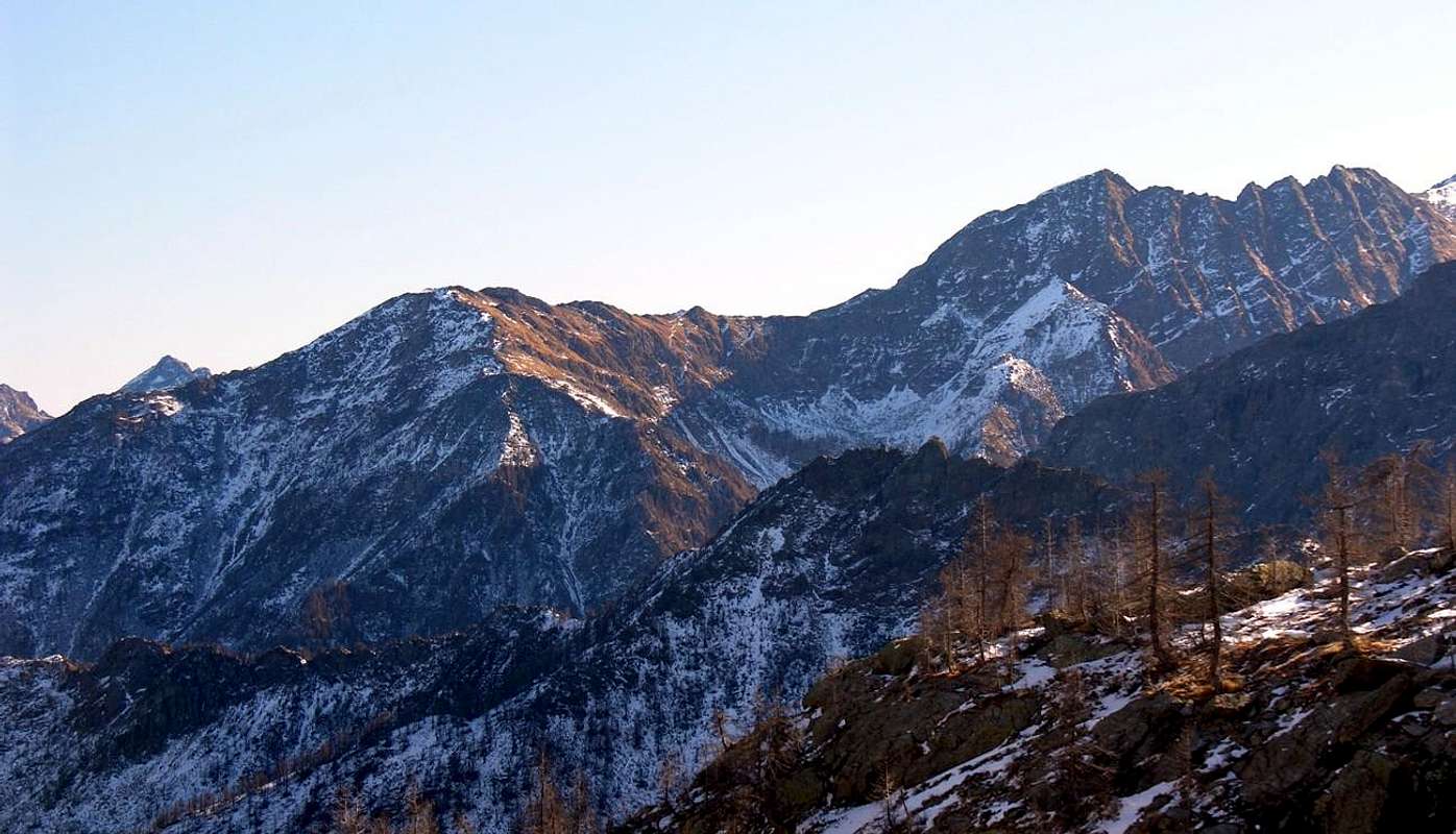 |
Questa Sommità fà parte del Gruppo del Monte Marzo (2.756 m), posto tra le Valli di Champorcher e Pianprato Soana e Chiusella in Piemonte. In realtà il gruppo di appartenenza risulta, anche se meno conosciuto, quello del Monte dei Corni (2.779 m), essendo questa la Sommità la più elevata in questo tratto di spartiacque con la Valle di Aosta e subito ad Oriente della precedente. Da questo ultimo scende verso Settentrione un contrafforte secondario, atto a separare il Vallone della Manda o Amanda ad Est da quello della Legna ad Occidente. Dopo il Colle della Fricolla (2.542 m) (*** collegamento tra i due nella loro parte più elevata tramite il Col Bruillet (2.450 m), ma in realtà si divide dal successivo Vallone di Brenve) la cresta si rialza all'omonima Punta (2.676 m), sopra il Lago Cornuto (2.450 m); quindi la cresta prosegue, sinuosa, formando la Cresta di Chenessy (2.756 m) che "seghettata" forma una serie di almeno quattro elevazioni (2.616 m, 2.665 m, 2.650 m, 2.616 m) prima di raggiungere la Punta di Chenessy (2.630 m). Questa, chiamata in B&V 1896, pagina 26 Costa di Canessi con quota 2.631 metri, anche se di poco meno alta si distingue maggiormente poiché isolata. Ai suoi piedi ad Est si trova il laghetto omonimo (2.383m), mentre sull'opposto versante scende con dirupi roccioso-erbosi al di sopra dell'Alpe Chenessy (2.051 m) nel Vallone attiguo della Legna. Una cresta rivolta a Nord-nordest continua ripida verso i Colli della Manda (2.390 metri circa m) e Detrà (2.350 metri circa), separati da una piccola Sommità 2.414 metri. Oltre lo spartiacque continua più a Nordest formando il tondeggiante Mont Giavin (2.431 m), il Col de Creuset (2.121 m) per terminare con il Mont Digny (2.145 m) sopra la Cresta di Lutta ed i piccoli Villaggi di Frassiney e Trambesere, ormai sul fondo valle. Sono montagne poco conosciute ed ancora di meno frequentate, se non dagli abitanti locali o da qualche amatore delle cose rare, come dimostra il misero tumulo trovato sulla Sommità (vedi foto), anche se per la verità "Guida delle Alpi Occidentali", identica pagina, segnala: "... punto culminante (segnale trigonometrico) della catena divisoria tra i valloni della Legna e della Amanda ..."; segno che oltre 100 anni prima era già cosciuta e frequentata. Almeno dai Topografi dello Stato Piemontese-Sardo, ma anche a dimostrazione che "Re Toio" era geloso dei suoi possedimenti e li controllava meglio di come fanno oggigiorno. Comunque rimangono valloni più frequentati dai Pescatori che dagli Alpinisti od Escursionisti, anche e forse soprattutto a causa dei lunghi ed estenuanti avvicinamenti. Questa vasta area, distendentesi ad Oriente verso il Canavese ed Ivrea ed a Sudest verso la Pianura Padana e la Città di Torino, costituisce le propaggini estreme del Gran Paradiso dopo le ultime importanti Sommità della Torre di Lavina e della Rosa dei Banchi, per la qual cosa appartiene ancora alla Catena montuosa delle Alpi Graie che da qui risale fino a quella del Monte Bianco. Da questa si godono piacevoli vedute sul circondario a partire dal Monte Marzo, ma anche su quella serie di piccole Cime semi abbandonate che si allungano verso la Bassa Valle. Frontalmente invece, approfittando della catena che dal Mont Glacier (3.186 m) digrada sempre più verso Est-nordest "aprendo" la vista, si posson ammirare le Valli del Marmore, Lys e Gressoney fino a lor termine, cioé al Cervino ed all'estesa Catena del Rosa dai Breithorns, Lyskamms, Zumstein, Dufour, Gnifetti ed al divisorio col Piemonte.
First Ascents
- First on the Summit: unknown.
- In winter: unknown.
- North-northeast Ridge: unknown.
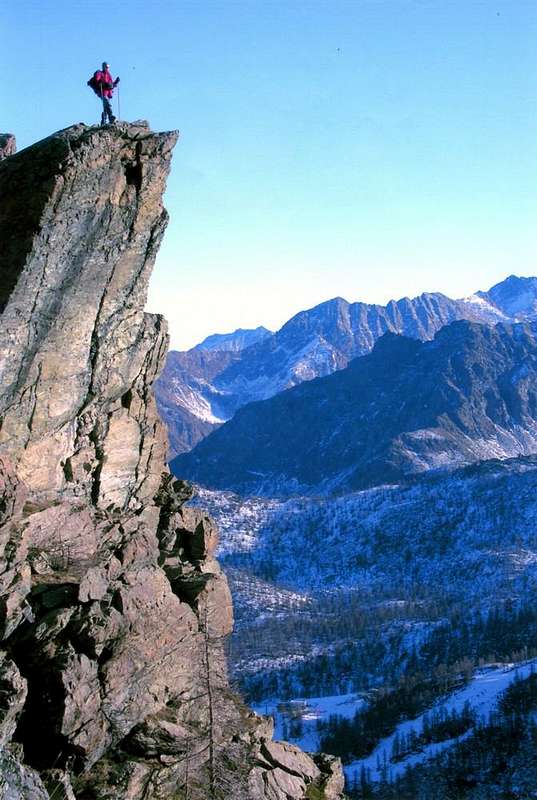
- East Edge: Osvaldo Cardellina and Emilio Bertona; Aug 03th, 2005, in ascent from Legna's Vallon.
- East-northeast Slope: Surveyors of the State of Piedmont-Sardinia; in the XIX° century.
Getting There
BY CAR:
- From TORINO, MILANO, etc: Motorway A5. Exit at IVREA or Quincinetto (PIEDMONT).
- From IVREA Town: Pont Saint Martin, Donnas, Hône, Bard, Pont Bozet, Champorcher Municipalities. From Hône Commune (364m), crossing the bridge above Dora Baltea, to Bard Municipality (566m; renowned Austrian Fortress) and through Regional Road towards Pont Bozet (775m) with the asphalt road to Champorcher Valley, up to the Outre l'Eve Hamlet (1.229m) at the beginning of Legna Vallon. After by meletrack and various paths. Also starting directly from Pont Bozet-Foliettaz/Delivret Villages (about 850/900 meters) with path in Southwest into the Manda or Amanda Vallon to the la Manda Alpages (2.003m), neighbor Chenessy (2.383m) and Cornuto (2.450m) Lakes, the slopes of the Eastern Tip of Chenessy.
- From FRANCE: through the Mont Blanc Tunnel to Entrèves-crossroads to Vény/Ferret Valleys nearby Courmayeur Resort. By Little Saint Bernard Pass, closed since November until half May to La Thuile Valley - Pré Saint Didier - Courmayeur. It is not necessary to take Motorway A5: you can drive on SS.26, in the direction of AOSTA - IVREA - TURIN.
BY PLANE:
- Aeroporto "Corrado Gex" Saint Christophe (Aosta).
Approaches
Approach A: from Outre l'Eve Hamlet through Legna's Vallon From Outre l'Eve (1.207/29m) take the trail n° 4 just West of the small village and go with Southeast direction to the Chapel of Cret (1.344m), where the same is directed more to the South. Immediately after reaching the junction at the Pian Bouch Pasture (1.354m) and, leaving the left (East) path n° 3C leading to Mont Digny, continuing instead to Southwest coming to Alp of Ourthy (1.344m), under the Vorèa Buttress where the trail splits. Leaving right branching in the Southwest that, through the path n° 4F, reach Lake Vercoche, continue to Southeast with the opposite entering the "true" Legna's Vallon. Turning next to the left of Legna Torrent (coming down from the Lakes Chiletto and Giorso) bank orographic you get to nearby Alps Sanaveus (1.781m) and San Antonio Case Vecchie (1.817m; Homes Old), where it still leaves on the right exit to Lake Chiletto. Continue always Southeast to Alp Creton (1.896m) without reaching the next Chenessy (2.051m). Here ends the approach and starts the route (E/F; 1h'30/2h'00). Approach B: from Pont Bozet Commune through Manda's Vallon By the Municipality of Pont Bozet (775m; above Ayasse Torrent with Parish Church built before 1600) continue through the Municipal Road for the two overlying small Villages Foliettaz and Delivret (between 850/900 meters), where the same ends. Take the path to the Southwest unnumbered leading in the Vallon of Manda also called Amanda. Exceeded in the progression of Pastures Devine (1.210m), Barettes, Cotetta, Barmafumo (ancient stone-wood "rascard") and Verney (1.298m) you will soon reach that of la Frête (1.388m) and, getting closer and closer to the Torrent de la Manda, subsequent to Bozet di Sotto and di Sopra (1.531m, 1.573m; Lower and Upper), where between Mont Digny Northwest and Bec Chaty and the Grand Bec in Southeast exists the intersections between three paths. Continue with the middle one that, always in the Southwest, arrives to the Alps Bataille, Chanton and finally la Manda (2.003m). From this, leaving the East to continue to Lakes Champas, Secco (Dry) and Nero (Black), continue towards West-southwest and no path, by means of a track between steep ridges grassy-rocky, but with the short path, to achieve connection between Mont Digny (2.145m) and Lake Chenessy (2.383m). From this, in a short time in the Southeast, reach the base of the East-northeast Slope, Eastern Face Punta Chenessy (EE/F; 4h'00/4h'30 from Delivret).
Avvicinamento A: da Outre l'Eve tramite il Vallone della Legna Da Outre l'Eve (1.207/29 m; Al di là dell'Acqua dell'Ayasse) prendere il sentiero n° 4 appena ad Ovest del villaggetto e salire con direzione Sudest alla Cappella del Cret (1.344 m), ove il medesimo s'indirizza più a Sud. Subito dopo raggiungere il bivio presso l'Alpe Pian Bouch (1.354 m) e, lasciando sulla sinistra (Est) il sentiero n° 3C conducente al Mont Digny (2.145 m), continuare invece a Sudovest arrivando all'Alpe d'Ourthy (1.344 m), sotto la Cresta di Vorèa formante un piccolo contrafforte, dove il sentiero si sdoppia. Lasciando a destra la ramificazione a Sudovest che, tramite il sentiero n° 4F, raggiunge il Lago Vercoche (2.202 m), continuare a Sudest con l'opposta entrando nel "vero" Vallone della Legna. Passando a fianco della sponda orografica di sinistra del Torrente della Legna, che scende dai Laghi Chiletto (2.322 m) e Giorso (2.160/70 metri circa), arrivare alle viciniore Alpi di Sanaveus (1.781 m) e subito dopo di Sant'Antonio Case Vecchie (1.817 m), dove si lascia ancora sulla destra la deviazione per il Lago Chiletto. Proseguire sempre a Sudest per l'Alpe Creton della Legna (1.896 m) senza raggiungere la successiva di Chenessy (2.051 m) Qui termina l'avvicinamento ed inizia la via (E/F; 1h'30/2h'00). Avvicinamento B: da Pont Bozet pel Vallone della Manda Dal Comune di Pont Bozet proseguire tramite la Strada Municipale per i due soprastanti piccoli Villaggi di Foliettaz e Delivret (850/900 metri circa), dove la medesima ha termine. Prendere il sentiero non numerato verso Sudovest che porta nel Vallone della Manda o Amanda. Superati in progressione gli Alpeggi di Devine, Barettes, Cotetta, Barmafumo e Verney (1.298 m) si raggiunge in breve quello di la Frête (1.388 m) ed, avvicinandosi sempre di più al Torrent de la Manda, i successivi di Bozet di Sotto e di Sopra (1.531 m, 1.573 m), dove tra il Mont Digny a Nordovest e Bec Chaty ed il Grand Bec a Sudest esiste la intersecazioni tra tre sentieri. Continuare con quello di mezzo che, sempre a Sudovest, arriva alle Alpi Bataille, Chanton ed infine la Manda (2.003 m); da questa, lasciando ad Oriente la continuazione verso i Laghi Champas, Secco e Nero, proseguire verso Ovest-sudovest e senza sentiero, per mezzo di una traccia tra ripidi costoni erboso-rocciosi, ma con breve percorso, raggiungere quello di collegamento tra il Mont Digny ed il Lago di Chenessy (2.383 m). Da questo, in breve a Sudest, raggiungere la base del Versante Est-nordest e la Faccia Est della Punta di Chenessy (EE/F; 4h'00/4h'30 da Delivret).
 |
 |
 |
 |
 |
Routes
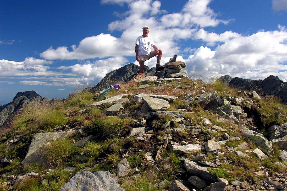
Route A: through Legna, Manda Vallons and East-northeast Face or Eastern Edge From Alpe Creton of the Legna (1.896m) head towards East with unnumbered path that leads to the Mont Giavin, but follow him for a short distance. Climb instead through ridges grassy-rocky progressively become increasingly steep, passing at some pine isolated, by means of a grassy gully exiting above the Col Detrà (about 2.350 meters). Important Note: this route is to be avoided with the wet ground or in high winds (personal experience), because it becomes very slippery and dangerous; in this case it is better to reach the nearby Mount Giavin (2.431m) and then cross to the South (see Via B). From Col Detrà continue on edge of the ridge to the South, and passed over the tiny Point 2.414 meters or going around it immediately to the East on a thin track, to quickly reach the next Pass of the Manda (about 2.390 meters). Since this does not continue, if not for short, along the North-northeast Ridge, but down towards the Southeast with a small trace diagonal that reaches the base of the Face East-northeast. Start climbing between large blocks scattered alternated with stretches with topsoil and grass indicating left against smooth rock walls gray and smooth; in part using these plates, you pass by a small spring, hemi occulted and of which you only hear the gurgling. Just above you can see the North-Northeast Ridge that is reached, with more strenuous climb that difficult, in the final part and using this for about twenty metres to the Summit easily with a mini stone cairn (EE/A; 2h'15/2h'45 from Creton della Legna Alpage). Variant: or, keeping more to the left (South) come up with a path "mixed" between this and wanting to climb, the rock slabs that make up the margin. In this case provide for a climb with various difficulties depending on the selected passages as well as relatively to the length of the latter; (from I° to III°), better with rope, carabiners and some lanyard.
Route B: from Mont Giavin With the path not numbered, starting from Alpe Creton della Legna, leave on the right (East) the previous route, but continued with the same which is directed more towards the Northeast. When this is turned into a small track that goes up the Slope Southwest, use the same for a short time; a detour to the left, not always easy to spot, leads to a characteristic shoulder on the West Crest, above the Alp Sanaveus. Follow this up with boring until the big rounded shoulder, where the path becomes more open and panoramic; by traces increasingly scarce, passing among some large boulders, more that easily reaches the Summit of Mont Giavin (2.431m). From this two possibilities:
1) - down in the Vallon of the Manda on a thin trail that goes to join at the Alp Detrà with a small path unnumbered diagonally reaching Lake Chenessy (2.383m) at the foot of the Face East of the homonymous Punta. Abandoning the same before reaching the pond and, swerving to the West, reaching the previous Via A. Or
2) - continue Southwards on the watershed and easy path to reach the Col Detrà, whence always previous Via A (EE/A; 3h'00/3h'30 by Creton of the Legna for both solutions). This second solution is quite useful down to fit in the Legna's Walloon, even if forced to a longer path but certainly more "enthrals" and safe, as well as much more scenic and panoramic to about 280°.
Route C: by North-northeast Crest This via is a little more challenging but more direct earlier. Reached the Col of the Manda you continue Southwards on the edge of the Ridge North-northeast. From the pass, reached with the previous Route A via the Legna's Walloon or with a small continuation to the North-northwest through that of Manda, you'll first pass on the edge of the ridge a stretch of rocks easy but mixed with grass, you can "cut" also to the left. The next steepest, challenging (I°+/II°-) is exceeded, always on the edge, or as in the previous bypass through a grassy gully interrupted by some rocky walls; follow around 60/70 meters simplest path that lead to two consecutive more steep parts. Are exceeded on wire (I°/I°+) or immediately in the vicinity reaching the easier terminal part formed by rocks somewhat routes with potting soil and often covered by grass (A; F to + PD-, depending on the selected passages; 1h'00/1h'15 from the pass; 3h'15/3h'45, by Creton). This crest is not difficult, but gentle to the poor quality of the rock, as well as in some stretch quite exposed. It also requires the ability to know find the way, for which it is not very advisable for Hikers, although Experts. Otherwise proceed with the Way A, just longer but safer.
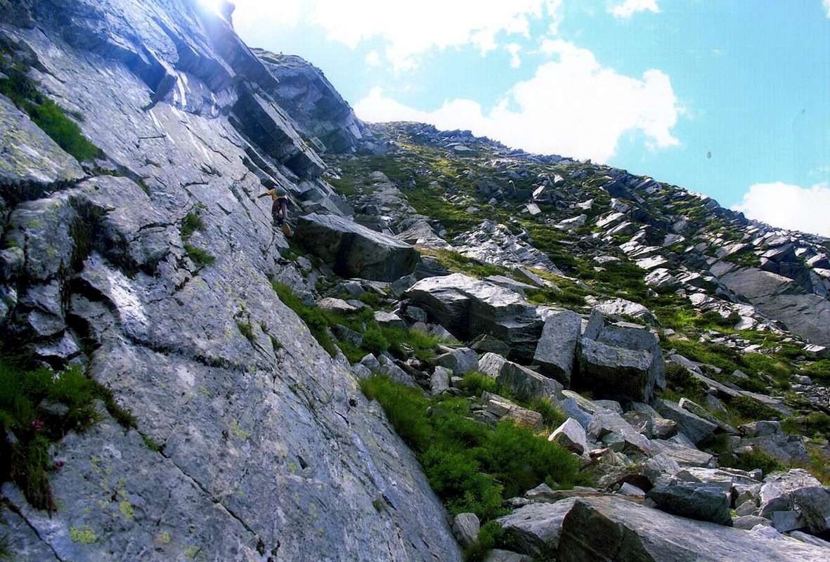 |
Via A: per mezzo dei Valloni della Legna e Manda e la Faccia Est-nordest o lo Spigolo Est Dall'Alpe Creton della Legna (1.896 m) dirigersi verso Est con il sentiero non numerato che porta al Mont Giavin, ma seguirlo per breve tratto. Salire invece tramite costoloni erboso-rocciosi progressivante sempre più ripidi, passando presso qualche pino isolato, per mezzo d'un canalino erboso uscendo sopra il Col Detrà (circa 2.350 metri). Nota importante: questa via é assolutamente da evitarsi con terreno bagnato oppure con vento molto forte (esperienza personale), perché diventa scivolosa nonché molto pericolosa; in questo caso é meglio raggiungere il vicino Mont Giavin e poi attraversare a Sud (vedi Via B). Dal Col Detrà proseguire in cresta verso Sud e, scavalcata la minuscola Punta 2.414 metri o aggirandola subito ad Est su di un'esile traccia, raggiungere in breve tempo il successivo Colle della Manda (circa 2.390 metri). Da questo non proseguire, se non per breve, lungo la Cresta Nord-nordest, bensì scendere verso Sudest con una piccola traccia in diagonale che raggiunge la base della Faccia Est-nordest. Iniziare a salire tra grandi blocchi sparsi alternati a tratti con terriccio ed erba portandosi sulla sinistra contro lisce banconate di roccia grigiastra e levigata; utilizzando in parte queste placche, si passa presso una piccola sorgente, semi nascosta e della quale si sente il rumore. Appena sopra si scorge la Cresta Nord-nordest che si raggiunge, con salita più faticosa che difficile, nella parte finale e tramite questa per una ventina di metri facilmente alla Sommità con mini ometto in pietra (EE/A; 2h'15/2h'45 dall'Alpeggio Creton della Legna). Variante: oppure, tenendosi maggiormente a sinistra (Sud) salire con un percorso "misto" tra questo e, volendo arrampicare, le lastre rocciose che costituiscono il margine. In questo caso prevedere una salita con difficoltà varie a seconda dei passaggi scelti nonché relativamente alla lunghezza dei medesimi; (dal I° al III°), meglio con corda e cordini.
From Sant'Antonio Case Nuove towards Detrà, Manda Hills and Mont Giavin, between Legna's & Brenve's Vallons
 |
 |
 |
 |
 |
Via B: dal Mont Giavin con il sentiero non numerato, che parte dall'Alpe Creton della Legna, abbandonare sulla destra (Est) la precedente via, continuando invece con il medesimo che si indirizza più a Nordest. Quando questi si tramuta in una piccola traccia, che risale il Versante Sudovest, utilizzare la medesima per breve tempo; una deviazione a sinistra, non sempre facile da individuarsi, conduce ad una caratteristica spalla sulla Cresta Ovest, sopra l'Alpe Sanaveus. Seguire questa con salita noiosa fino al raggiungimento della grande spalla arrotondata, dove il percorso diventa più aperto e panoramico; tramite tracce sempre più scarse, che passano tra alcuni massi, più che facilmente si raggiunge la Sommità del Mont Giavin (2.431 m). Da questo due possibilità:
1) - scendere nel Vallone della Manda su d'un esile traccia che và a congiungersi presso l'Alpe Detrà con un sentierino non numerato in diagonale raggiungente il Lago di Chenessy (2.383 m), ai piedi del Versante Orientale dell'omonima Punta. Abbandonarlo prima di raggiungere il laghetto e, deviando ad Ovest, raggiungere la precedente Via A. Oppure
2) - continuare verso Sud sullo spartiacque e con facile percorso raggiungere il Col Detrà, donde sempre alla precedente Via A (EE/A; 3h'00/3h'30 dal Creton della Legna per entrambe le soluzioni). Questa seconda soluzione risulta alquanto utile in discesa per rientrare nel Vallone della Legna.
Via C: tramite la Cresta Nord-nordest Questa via é di poco più impegnativa ma maggiormente diretta delle precedenti. Raggiunto il Colle della Manda si continua verso Sud sul filo della Cresta Nord-nordest. Dal colle, raggiunto con la precedente Via A tramite il Vallone della Legna o con una piccola continuazione a Nord-nordovest tramite quello della Manda, si supera dapprima sul filo di cresta un tratto di rocce facili ma frammiste con erba, che si può "tagliare" anche a sinistra. Il successivo tratto più ripido, impegnativo (I°+/II°-) si supera sempre sul filo o come nel precedente aggiramento tramite un canalino erboso interrotto da alcuni muretti rocciosi; seguono 60/70 metri di percorso più semplice che conducono a due risalti consecutivi. Si superano sul filo (I°/I°+) o subito nelle vicinanze raggiungendo la più facile parte terminale formata da rocce alquanto rotte con terriccio e spesso ricoperte da erba (A; da F+ a PD-, a seconda dei passaggi scelti; 1h'00/1h'15 dal colle; 3h'15/3h'45 dal Creton). Questa cresta non é difficile, ma delicata per la qualità scadente della roccia, nonché in alcuni tratto abbastanza esposta. Inoltre richiede la capacità di sapere individuare la via, per la quale cosa non é molto consigliabile per gli Escursionisti, anche se Esperti.
 |
Difficulties & Equipment
From F+ to PD- for the Route A. From F to F+ for the Route B. From F+ to PD for the Route C. From PD- to AD- for the Variant on Eastern Edge of Route A.Da F+ a PD- per la Via A. Da F a F+ per la Via B. Da F+ a PD per la Via C. Da PD- a AD- per la Variante sullo Spigolo Est dalla Via A.
For Hiking, better with rope, carabiners and some lanyard for the Variant to Via A.
Da Escursionismo, meglio con corda, moschettoni e qualche cordino per la Variante alla Via A.
Mountain Conditions
- You can get meteo information at the official site of the Regione Valle d'Aosta:
- Valle d'Aosta Meteo
Important Information
- REGIONE AUTONOMA VALLE D'AOSTA the official site.
- FONDAZIONE MONTAGNA SICURA Villa Cameron, località Villard de la Palud n° 1 Courmayeur (AO) Tel: 39 0165 897602 - Fax: 39 0165 897647.
- A.I.NE.VA. (Associazione Interregionale Neve e Valanghe).
Useful Numbers
- Protezione Civile Valdostana località Aeroporto n° 7/A Saint Christophe (Ao) Tel. 0165-238222.
- Bollettino Meteo (weather info) Tel. 0165-44113.
- Unità Operativa di Soccorso Sanitario Tel. 118.