Early Morning Drive
![Rabbit and Villager Peaks google earth image]() Google Earth Image of Route
Google Earth Image of Route![Clark Well]() Clark Well Area
Clark Well Area![Rabbit and Villager Route Topo Map]() Topo Map of Route
Topo Map of Route
It is 3:15 am on Sunday 2/17/08 and I am rushing to get ready. I ask myself "why am I doing this?" I only get 2/7th of my days off and even fewer chances to sleep in and I am getting ready to drive 3 hours so I can punish myself on a grueling hike of Rabbit and Villager peaks (possibly even Rosa Point). Then I will have to drive back in traffic so I can get to bed for work tomorrow. Unlike some, I do not get the luxury of having President’s day off of work. I always seem to question myself like this before a hike, but as usual I have made a commitment to hike and in this case Tom is already at the trailhead having arrive last night.
So I load up my stuff and hit the highway just after 3:30 am. I figure that traffic should be very light at this hour, but of course I am surprised with an accident and the I10 East is shut down. My detour (which involved detouring yet another accident on the 60E) puts me behind schedule by 30 minutes. Other than that, the drive out is uneventful. The sun is rising as I drive along the Salton Sea. For some reason this area really intrigues me. The whole reason why this body of water is here is due to environmental blunders, and the sea is dying due to increasing salinity. The communities along its shores dwindling away. I can smell something fishy in the air. But yet, a new Casino has been built. Maybe there is hope for these communities yet? Either through gambling revenue or from what appears to be a very popular activity of off road driving. There are hundreds of these RVs with OHV carriers built into them all over the desert in what resembles a community.
Ascent of Rabbit Peak via West Rib
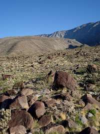
![Trek across desert to Rabbit Peak]() Trek across desert to Rabbit Peak
Trek across desert to Rabbit Peak![Ascending west rib to Rabbit peak]() Ascending west rib to Rabbit peak
Ascending west rib to Rabbit peak![West Rib to Rabbit]() West Rib to Rabbit
West Rib to Rabbit![Rabbit Peak]() Rabbit Peak
Rabbit PeakI continue on away from the Salton Sea west down SR22, past all of the OHV camps and on towards the trailhead. I meet Tom at 6:30 am and we quickly drop off my car and drive on some dirt roads, over Dry Clark Lake to Clark Well since we are planning on tackling Rabbit from the west. I had read that you can get ticketed for parking in this area, and there are plenty of Private Property signs, however the OHV camps are all over the place so we assume that the private property is not enforced and continue on with little worry. We head towards the waypoint I have in my GPS for Clark Well until the road gets too narrow and sand filled to continue. We did not quite make it all the way to the well but pretty close. We start hiking by 7 am. Already behind schedule if we have any hope of being able to include Rosa Point in this hike. We head straight towards Rabbit Peak, passing the remains of Clark Well. At some point in the not-too-distant past this area looked to be inhabited and we were surprised to see the well had new valves and piping, giving us the impression that it was still operational. We passed an upside-down Volkswagen van and joked that they were the last ones who dared park here in order hike Rabbit Peak. From Clark Well to the start of the main ridge leading to Rabbit was approx. 3 miles of tedious desert travel involving going in and out of many ravines, dodging Ocotillo and cacti, and navigating between large boulders. We had planned on this desert travel being much easier. Then to top it off we have to navigate a huge wash right before gaining the main ridge. From the bottom of the wash we climbed onto this steep ridge and started gaining elevation. Once on the ridge the route was marked fairly well with rock cairns and other than dealing with the steepness we proceeded without issues. There were a couple of saddles that required losing some elevation we had gained, which I always hate to do. At one point we looked at the ribs descending down from the main ridges between Villager and Rabbit peaks and tried to determine our route. The closest rib looked very intimidating; very steep, rocky and long! I figured we were going to continue along the ridge to the smaller rib, however Tom correctly pointed out that we would then be to the north of Rabbit. I used the "goto" function of my GPS to determine that indeed we needed to climb the very steep, long ridge directly ahead of us. We continued along our current ridge past a couple more saddles and previous camp spots until we were at the base of this rocky rib looking up. I made a point that it doesn’t look any steep or longer than the ridge we had climbed last weekend to gain Iron Mountain’s southwest ridge. But that was not overly encouraging either, as that ridge kicked our asses just as this one was about to do. Well, up we went. The ridge stayed at class 2 however I would say that it was a very steep class 2, and unrelenting as well. If you look at the topo map you will see that we climbed over 3000 ft in about ¾ of a mile (starting at mile 5). That is steep! We were both not climbing at our best either. I figure lack of sleep was effecting me. Tom was not sure what ailed him. But we both felt light headed and made slow work of the ridge. Once we reached the main ridge we could see a group ahead of us. It was the Sierra Club group that Tom indicated left just after 6 am. I was disappointed that they were ahead of us, I was sure that our "shorter" route would get us ahead of them. At this point Tom and I packed some snow (there were patches everywhere) into our hydration bladders since we had been drinking a lot of water and started up the final ridge to Rabbit. It was nice that we now had trail to follow, however this final ridge was still steep and we were both struggling. Once at the summit I met the Sierra club group and saw who was leading them. I then did not feel as bad that we had not beat them to the summit. I had hiked with the leader before and he was extremely fast. And it looks like he had a very fast group with him as well. We made it to the summit in 5.5 hours. It took them 6 hours. At this point Tom and I realized that these shorter, steep routes typically are not any faster than the longer, more gradual routes. The route finding and off trail navigation combined with slow ascent up precarious ridges consumes any timesavings you might have gained going the shorter (less mileage) route.
Bumpy Traverse to Villager Peak and Beyond
![Villager Peak Summit Carin]() Villager Peak Summit Carin
Villager Peak Summit Carin![View towards Villager from Rabbit PEak]() View towards Villager from Rabbit Peak
View towards Villager from Rabbit Peak
We enjoyed the views, signed the summit register, ate lunch and started on towards Villager Peak. There are 7 “bumps” along the ridge between Villager and Rabbit and this additional elevation gain climbing these bumps was still taking its toll on Tom and I. We left after the Sierra Club group and did not catch up with them until we were on the summit of Villager. They were moving fast. On Villager we discussed our tentative plans of ascending Rosa Point as well. The Sierra club timekeeper pointed out that they were not going to get down until 6 pm (6:17 pm to be exact). They were moving quick and he seemed very accurate in his times. Therefore we figured that a detour to Rosa Point would mean we would be descending most of the way, along an unknown ridge dotted with cacti that seemed to some how attack you in total darkness. I had to work tomorrow so wasn’t thrilled about getting down so late. Plus I had to drive my Honda Civic out across the dry lakebed to pickup Tom’s Honda Element and I was a little nervous of getting stuck. Daylight would be preferred for this drive. We figured we would make our final decision whether to give Rosa a try or not at the departure point further down the ridge. At this point I suggested that we take one of Villager’s ridges straight down to Tom’s element since it looked like Rosa was out. But looking down the suitable ridges Tom said “no way are you getting me down that”. I have to admit they were steep, especially at the bottom, but doable. Well, giving up on talking Tom into descending one of Villager's west ridges we continued down the trail towards SR22. The ridges just go on and on and the desert floor does not seem to be getting any closer. After a short while we could see the ridge leading to Rosa Point and immediately ruled out trying to ascend Rosa Point. We would have to loose several thousand feet the get to the saddle and then climb back up what looked like a longer, steeper ridge that the one we already ascended to Rabbit Peak. I made the statement that I did not have enough energy for that ridge and it was final. Well I have no doubt we could have done it, but it would not have been wise. In order to combine all three of these into one hike I suggest an alpine start (start hiking just after midnight to save daylight for the tricky descent).
Long Descent
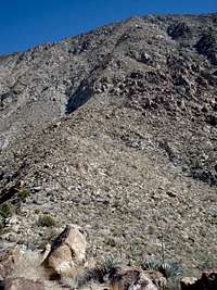
![End of the trail and onto the deset floor]() End of the trail and onto the deset floor
End of the trail and onto the deset floor![Rugged terrain on descent from Villager Peak]() Rugged terrain on descent from Villager Peak
Rugged terrain on descent from Villager Peak![View of ridge to Rosa Point]() View of ridge to Rosa Point
View of ridge to Rosa Point
From this point down it was just more of the same. Lots of cacti, rocks and ridges. With the sun getting low on the horizon the area took on a beautiful glow, which seemed to really accentuate the area's beauty. The desert certainly is beautiful with a lot of colors, variety and life. Certainly not barren and desolate. I took many photos.
As I usually do, I started to speed up on the finial descent. We could see the cars now and they still seemed very far away, and I was racing the sun in hopes of having light to navigate the dry lakebed (to avoid the muddy and sandy sections). I thought of Pink Floyd’s lyrics: “I run and I run to catch up with the sun but it’s sinking, racing around to come up behind you again. The sun is the same in a relative way but your older, shorter of breath and one day closer to death”. We made it back to my car by 5:30 pm for a total of 17.5 miles and 7150 ft elevation gain in 10.5 hours. We hopped into my car and raced off to get Tom’s Element from Clark Well. The Honda did great driving through the dry lakebed and my concerns about getting stuck were not warranted. Soon we had reached Tom’s element and I dropped him off and started my journey home. I arrive home at 9 pm, ate a huge, late dinner, had a very nice shower and went to bed feeling good. I also felt good Monday. I had a deep sleep and hiking has a way of raising my spirits, makes me feel positive about things and provides a nice start to the week. I am not shorter of breath and closer to death as per the Pink Floyd lyrics, but instead I feel like by being active I am postponing my eventual death by maintaining good physical condition. Now if I can just motivate myself to exercise during the week as well I should be able to live to be over 100 :)
Flora Photo Album
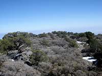
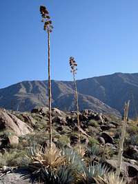
I really enjoyed checking out the flora on this hike. So much so that I sort of dedicated this trip report to all the plants I saw, providing many photos of the flora I found. During our ascent, originally we were seeing a lot of Ocotillo, Creosote Bush, and Barrel and cholla cacti. But as we ascended we started to see a lot more agave, yucca and then juniper and pinyon pines near the top.
Here is a more detailed Botanical Trip Report for this area.
![Agave found on the ascent to Rabbit Peak]() Agave Agave |
![nolina near Rabbit Peal]() nolina nolina |
![Ocotillo on ascent to Rabbit]() Ocotillo Ocotillo |
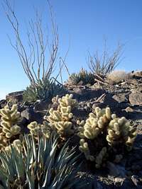
![cholla cactus]() cholla cactus cholla cactus |
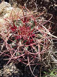
![Barrel Cactus found on ascent of Rabbit Peak]() Barrel Cactus Barrel Cactus |
![More cacti on the descent]() Teddy Bear Cholla - these guys attack! Teddy Bear Cholla - these guys attack! |
![Cacti found on the ascent of Rabbit Peak]() Flowering Fishhook Cactus Flowering Fishhook Cactus |
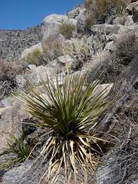
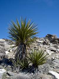
![Mojave Yucca near Rabbit Peak]() Mojave Yucca Mojave Yucca |
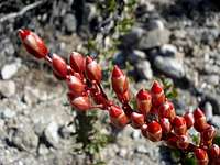
![Ocotillo flowers on ascent to Rabbit]() Ocotillo flowers Ocotillo flowers |
![Barrel and Ocotillo on descent from Villager Peak]() More Barrel Cacti More Barrel Cacti |
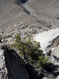
![Pinyon Pine enroute to Rabbit Peak]() Pinyon Pine Pinyon Pine |
![More cacti found on ascent of Rabbit Peak]() pancake prickly pear pancake prickly pear |
![Creosote Brush]() Creosote Brush Creosote Brush |
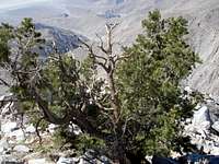
![Junper looking down Rabbit s West Rib]() Juniper Bush Juniper Bush |
![Pencil cactus]() Pencil Cactus Pencil Cactus |
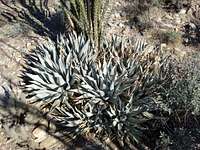
![Silver Agave]() Silver Agave Silver Agave |
GPS Data and Photos
Here are my GPS tracks for downloading and Google Map of the route.
http://www.gpsmountaineering.com/rabbitandvillagerpeaks
More photos can be found Here:
http://www.flickr.com/photos/trav_and_jenn/sets/72157603935242029/


Comments
Post a Comment