
|
|
Area/Range |
|---|---|
|
|
40.33030°N / 106.1361°W |
|
|
Hiking, Mountaineering, Trad Climbing, Bouldering, Scrambling, Skiing |
|
|
Spring, Summer, Fall, Winter |
|
|
12296 ft / 3748 m |
|
|
Overview
The Rabbit Ears Range is one of the lesser known ranges in north central Colorado and is not as well known as the other nearby ranges such as the Park Range, Medicine Bow Range, Never Summer Range, Rocky Mountain National Park, the Indian Peaks and the Gore Range. Part of the reason why the Rabbit Ears Range is lesser known than many of the other ranges in the area is because overall it isn’t as high or quite as spectacular as those other ranges, however it is unusual for the area in that at least two of its mountains (Rabbit Ears Peak and Chimney Rock) require technical skills and gear via their easiest routes.The Rabbit Ears Range divides the extensive valleys of North and Middle Park and extends from Rabbit Ears Peak on the west to Radial Mountain on the east. The range forms an east west bridge between the north to south tending Park Range on the west and the north to south Never Summer Range on the east. Since the range blends in to the Park Range on the west, there seems to be some confusion about which peaks belong to which range, but the Rabbit Ears Peak themselves belong to the Rabbit Ears Range in most sources I’ve seen (including the prime source on this region; Joseph Kramarsic’s book The Continental Divide Mountains of Colorado’s Rabbit Ears Range).
The range is overall unusual in North America since it runs west to east rather than north to south, but interestingly some of other ranges in this region, the Williams Fork Mountains(west of Steamboat Springs) and the Elkhead Mountains also run west to east. The Rabbit Ears Range is almost entirely made of volcanic rocks. Many volcanic dikes and plugs are visible throughout the range (the best ones being around Radial Mountain) and several examples of columnar jointing can also be seen (such as on Whitley Peak and the Devils Post Pile on White Slide Mountain).
 Whitely Peak a seen from Highway 40.
Hiking, Peak Climbing, and Rock Climbing
HikingThere are several trails throughout the range, including the famous Continental Divide Trail. Other than this trail and the trails around Parkview Mountain and Rabbit Ears Pass, most trails in the range receive light use.
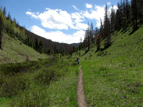 Trail along Buffalo Creek.
Peak Climbing
As mentioned, most of the peaks are non-technical and have relatively easy rolling slopes. Parkview Mountain at 12,296 feet is the highest in the range, while Whitely Peak is undoubtedly the most spectacular in the range. Unfortunately Whitely Peak is blocked by a narrow strip of private land all the way around the peak. Most peaks in the range are easy walk ups, but many of the routes are steep and strenuous. Relatively few peaks have trails to their summits.
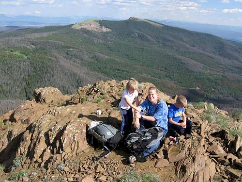 The summit of the Corral Peaks.
Rock Climbing
Rabbit Ears Peak, Chimney Rock and the Devils Post Pile offer rock climbing, but the rock is rather loose throughout the range. Only skilled rock climbers should consider rock climbing here, especially since the volcanic rock tends to be loose.
The exception is the Rabbits Back/West summit of Rabbit Ears Peak (not the ears themselves). The rock there seems to be fairly solid, at least comparatively speaking.
 Shaylee on the west summit of Rabbit Ears Peak
 Camping
There aren’t many official campgrounds around the range, but a few do exist around Willow Creek (Highway 125) and west of Rabbit Ears Pass (Highway 40). There are many opportunities throughout the range for primitive camping and good campsites abound.Backcountry camping is possible, but most climbs here are day climbs so it’s seldom done except for those hiking the Continental Divide Trail. The Troublesome Creek area has some nice backcountry loops as well.
Seasons
Summer is the most popular season to climb here, but other seasons offer their attractions as well. The range offers good skiing and snowshoeing in winter and spring. Many of the areas of the Rabbit Ears Range are beautiful in the Fall.Most of the access roads aren’t open in winter, so winter climbing here is less accessible than in some of the other surrounding ranges, at least without having a snowmobile. Highway 40 is open year round and is highway 125, so peaks near either of those highways are very accessible in winter.
Parkview Mountain and Radial Mountain are two of the most accessible peaks to climb and the Rabbit Ears Peak area and Baker Mountain are very accessible as well.
 Parkview Mountain in early June.
Mountain Conditions
For more information, contact:Sulphur Ranger District
9 Ten Mile Drive
Granby, CO 80446
970-887-4100
WEATHER FORECAST
Below is the climate summary for nearby Berthoud Pass at 11,315 feet elevation which is several miles to the south and about the same elevation as many of the peaks in the Rabbit Ears Range. These are all averages, so expect more variation, but this will give you a good idea about the climate at higher elevations of the Rabbit Ears Range. National Weather Service Data 1950-1985.
| MONTH | HIGH | LOW | SNOW DEPTH | DAYS W/PRECIP |
| JAN | 21 | 1 | 42" | 19 |
| FEB | 24 | 2 | 52" | 16 |
| MAR | 29 | 6 | 63" | 20 |
| APR | 36 | 14 | 67" | 17 |
| MAY | 45 | 23 | 53" | 16 |
| JUN | 54 | 32 | 17" | 11 |
| JUL | 62 | 39 | 0 | 14 |
| AUG | 60 | 38 | 0 | 14 |
| SEP | 53 | 31 | 0 | 11 |
| OCT | 42 | 21 | 3" | 10 |
| NOV | 30 | 10 | 14" | 15 |
| DEC | 23 | 3 | 29" | 18 |