
-
 6504 Hits
-
 86.37% Score
-
 22 Votes
|
|
Route |
|---|---|
|
|
37.62185°N / 119.08579°W |
|
|
Hiking |
|
|
Fall |
|
|
Less than two hours |
|
|
trail |
|
|
Overview
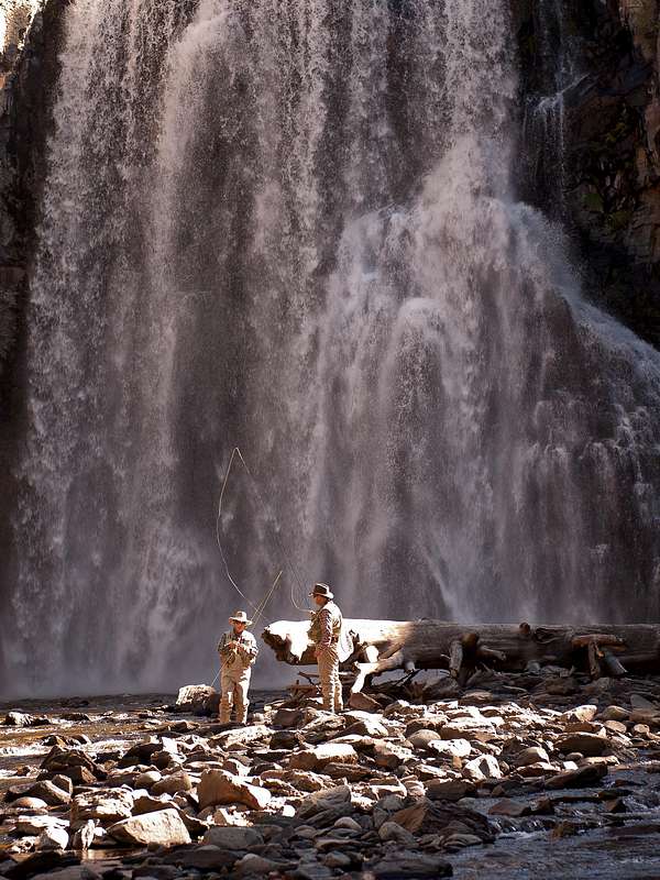
Rainbow Falls are a spectacular 101 foot waterfall in the Devil’s Postpile National Monument. After lazily meandering through the meadows of the Monument, the waters of the Middle Fork of the San Joaquin River suddenly plunge over a volcanic cliff creating the falls. The hike to the falls is a very easy and short outing ideal for groups with smaller or older people. The elevation loss on the way to the falls and gain back to the trailhead is nearly negligible. The first part of the hike leads through a beautiful open lodgepole pine forest before entering the Ansel Adams Wilderness. The second part leads through the remnants of the lightning-caused Rainbow Fire to an overlook of the falls. Although already impressive from the overlook, the view from the riverbed and facing the falls is definitely unforgettable and breathtaking.
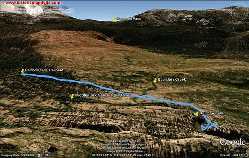
The stroll to the falls from the Rainbow Falls trailhead and back is about 3 miles roundtrip with 400 feet of elevation loss and gain.
|
Trail
From the Rainbow Falls trailhead the trail leads in southerly direction on a well-maintained trail through the lodgepole pine forest. Very soon you will cross the Pacific Crest Trail. Continue straight, leave the forest shortly thereafter, and walk through the remains of the Rainbow Fire. The fire was caused by lightning on August 20, 1992, and burned about 3,300 ha by September 8. 82% of the Devil’s Postpile National Monument has burned. You enter the Ansel Adams Wilderness and cross Boundary Creek, a small tributary to the Middle Fork of the San Joaquin River. During fall, gorgeous aspens in their fall splendor line the creek. A few minutes later you will have a first look at the Middle Fork of the San Joaquin River, as it peacefully makes its way to the falls. After a few steps downhill, you approach an overlook with impressive views at the falls. Follow the trail a short ways further and you can take steep stairs down to the riverbed and stand face-to-face with the falls. That view truly is memorable and breathtaking. Be careful however, as the steps may be very slippery. Marvel at the falls as the water plunges over a cliff of volcanic rock 101 feet down. As the Middle Fork cascaded over its former bank, its water eroded into the softer rock at the base and undercut the harder massive rock above, causing it to cave in. The cliff has thus retreated 500 feet or more upstream to the present location of Rainbow Falls. After climbing back up the stairs you can hike about another 0.5 miles further downstream to the Lower Falls or retrace your steps back to the trailhead.
| Middle Fork San Joaquin River | Rainbow Falls |
|---|---|
 |
 |
Getting There
From Highway 395, take the exit to Mammoth Lakes (Highway 203). Turn left and follow the road past the visitor center to your right through town. At Minaret Road turn right towards the Mammoth Ski Resort.
During the busy summer months the traffic into the San Joaquin Valley is restricted and you are required to take a shuttle bus from the main lodge down into the valley. Depending on the snow conditions, the road usually is open from mid June to early September. In 2011 the bus operated from June 29 to September 7. During that time leave your car at the Mammoth Ski Resort Main Lodge and board the Reds Meadow Shuttle Bus. The day pass is $7 for adults and $4 for children (3-15). Children under 2 ride for free. Three-day passes and annual passes are also available. The first bus leaves the main lodge at around 7:15am and departs around every 15 to 20 minutes (from 9am to 5pm). Once in the valley the bus stops at many places along the route. To hike to Rainbow Falls you can exit the bus at the Devils Postpile, Rainbow Falls, or Reds Meadow stop. The shortest way is from the Rainbow Falls stop. Once you exit the bus a short walk through the forest on a dirt road will take you to the trailhead with restrooms facilities.
Under the following conditions you are exempted from the mandatory bus ride and can drive your car down into the valley:
Parties with a valid disabled persons parking placard or plate
Campers staying in a valley campground
Guests of the Red's Meadow Resort
Vehicles towing stock trailers or carrying watercraft
Hunters transporting weapons or large game
Vehicles arriving before 7:00am or after 7:00pm
If you don’t take the shuttle bus you have to pay entrance fee at the Minaret Vista Station, which is $10 per vehicle for a day pass. Outside the season when the shuttle bus operates and the road is open you have to pay entrance fee at the Minaret Vista Station during the day also. During winter the road is normally blocked at the Mammoth Mountain Main Lodge (Ski Resort).
More info can be found at the NPS website:
Devils Postpile
Google Earth
|
|---|
Essential Gear
No essential gear is necessary.