
-
 3872 Hits
-
 78.27% Score
-
 9 Votes
|
|
Route |
|---|---|
|
|
46.25020°N / 13.69535°E |
|
|
Hiking |
|
|
Spring, Summer, Fall |
|
|
Most of a day |
|
|
Medium hard hike |
|
|
Rating the Route (By Hiking Standards)
The grading system for hiking and scrambling routes is here.
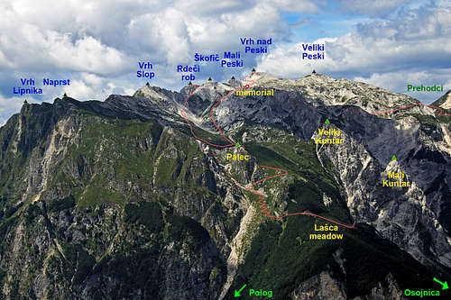
0. General: From 458 m to 1913 m, exposition E. Till Lašca alpine meadow not marked, but good, only on one or two places a bit exposed path. Above we use less and less evident old military paths. From Lašca till Mala rupa still a good path, later hard to follow. The ascent on the summit ridge over a pathless, steep, grassy slope. Gear: Good shoes and hiking poles.
1. Effort: cca 1460 m, 5 h.
2. Power: 1 - No difficulties, only walk-up.
3. Psyche: 2 - Easy.
4. Orientation: 3 - Medium.
Getting There

Javorca memorial church

Tolminka valley
See the parent page of Rdeči rob how to get into the Valley of Tolminka. We park before Polog alpine meadow, 457 m, or on the first turn of the road towards the Javorca church.
Route Description

Above Planina pod Osojnico
Before Polog meadow the road is closed for public traffic, so we continue by a marked, good cart-road towards the north (up the valley). After some 20 minutes the path starts ascending in several switchbacks over the slopes of Železje hill. On the other side we reach the hunters hut by the sources of Tolminka river. Further on, the marked path crosses the already dry river bed and continues towards the north, so we must on the nearby Planina Pod Osojnico (meadow) find the continuation of the path, which continues by the valley towards the north-west. When we find ourselves in a broad ravine, full of sands and boulders, we must find the trail on the other, NE side, although continuing by the ravine would also bring us above on the path (after 1 hour). Anyway, above this ravine we see the rocky summits of Mali and Veliki Kuntar, their lower rocks are our target to reach. By the hunters hut V vrticih the path leads us up, above it ascends more westwards, crosses the big ravine and over soft sands gains another 50 meters below Kuntar. There's the trails branching and our trail finally starts crossing the slopes horizontally towards the south.

Lasca meadow

Towards Lašca meadow
Crossing the next ravine depends on the status of the path. It is used for bringing cattle up on the meadow, but in steep slopes it soon gets eroded, below one rock we even found a tool to repair it if necessary. Later the path goes by a nice ledge around a panoramic corner and reaches the lower meadows of Lašca. After some more 15 minutes we reach the dreamy beautiful meadow with a few good huts, standing on a very panoramic terrace.

Going around Palec

Above Lašca meadow
The old military and perhaps shepherds trail continues on the upper, western part of Lašca meadow. After a short ascent we go left around the corner into a broad, steep grassy valley, called Laški plaz. This valley is a natural passage between Vrh Lipnika on the left and Palec on the right. A bit higher it looks like a dam, but it's our path, crossing the valley towards the right. There it goes sharply right, around Palec, reaching first the grassy shoulder NE of it and then crossing the whole northern slope of Palec in a big arc towards Mala rupa. We gain some altitude and behind a grassy hill find a flat meadow, where once shepherds kept sheep and goats. The path turns around the soft grassy hill back towards the left and keeps ascending in a southern direction. These paths have their strange logic, a mountaineering path would go directly up by the ridge of Palec.

On the summit ridge

Approaching the summit
Soon after Mrzla rupa we must leave the quite good military path, which continues westwards, and go by a tiny path, which crosses the broad grassy slope all the way towards the south. We continue some 15 minutes, first horizontally, then slightly ascending, and reach the edge of a shallow basin below the main ridge (screes, boulders). There we must deter right again. At first we don't see any path, higher the path comes from the right again and we use it towards Rdeči rob. The red rock of our goal is already clearly seen, we ascend by the right side of a shallow valley towards its north ridge. The more we approach Rdeči rob north ridge, the more the trail gets lost in a steep grassy slope. It is best to decide to go steeply up and gain the ridge directly. This part is very enduring and steep, but not dangerous.
On the north ridge we hit the ridge trail, turn left and over steep, red edge reach the summit in a few minutes.
Hint 1: It is very likely that the shortest route from Lašca meadow would be by the steep valley of Laški plaz directly up. That means by the valley between Vrh Lipnika on the left and Palec on the right. So we would cut the long detour of Palec and reach the scree basin below the main ridge directly. From there (the last crossroads), we would just continue in the same direction on top, as described above.
Hint 2: Also from Polog it looks that a very steep path goes directly on the Lašca meadow. But we haven't used it and we don't know how difficult it is to track.
Descent

Descent: Planina Medrja
We can ofcourse descend by the same route, which must be boring enough. It is much more interesting to descend towards the west and do a round tour. Those, who ascended the summit of Rdeči rob from the west, will have no problems to find the descent passage, of course. But if we came from the east, we must carefully examine the abysses, which are falling from the north ridge towards the west. There is only one passage, look for ciarns directing you towards it. From top you must descend by the north ridge and soon after the first saddle, where the rock colour turns from red into white, go left above the abysses. A steep, grassy ramp will take you some 50 meters down. Then just descend by the non-marked path into the basin, where the marked path from Jezero (lake) v Lužnici comes. Return to Sleme meadow and down to Tolminka valley as described on the main page, route #2. Around Mali Stador take the lower marked path, it is easier and perhaps faster.