
|
|
Trailhead |
|---|---|
|
|
42.15128°N / 74.13179°W |
|
|
Spring, Summer, Fall, Winter |
|
|
1965 ft / 599 m |
Overview
This parking area/trailhead gives acess to some great Catskill peaks as well as the Devils Path. The land surrounding the parking area is all within the Indian Head Wilderness land and camping is allowed on both sides of the road (observe all Catskill mountain regulations, see red tape). An old stone quarry is located close by where some people have have created some interesting stone configurations including large stone chairs, which one could sit and look north to Round Top and Kaaterskill High Peak. There is also a beaver pond and just some beautiful forest areas.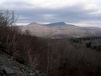 View from the rock quarry area
Mountains closely acessable from this parking area/trailhead
-Twin: (3640 ft.) 2.7 Mi. 1675 Elev. gainFrom the trailhead follow the Roaring Kill Trail (yellow markers) for .25 Mi. Then left onto the Pecoy Notch Trail (blue markers) for 1.7 Mi. At the junction with the Devils Path, turn left and the summit will be reached in .75 Mi.
-Sugarloaf: (3800) 3.15 - 3.8 Mi. 1835 Elev. gain
Option 1:Follow the same Instructions as above except at the Devils Path Junction, go right and the summit will be reached in 1.2 Mi.
Option 2: Go .25 Mi. on the yellow blazed Roaring Kill Trail and turn right onto the blue blazed Mink Hollow Trail, travel 2.65 Mi.
At the junction with the Devils Path, go left for .9 Mi. to the summit of Sugarloaf.
-Plateau: (3840) 4.9 Mi. 1875 Elev. gain
Follow the same directions as option 2 above except at the juntion with the Devils Path go right for 2 miles to the summit of Plateau.
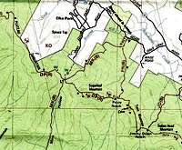 Roaring Kill parking area/Trailhead is the "P" at the top right of the map.
NOTE: The Devils Path is very steep in sections requiring some class 2+ scrambling.
Recommended maps and books
I highly suggest the maps by the New York/New Jersey Trail Conference. These maps are quite accurate making both trail travel and trailhead locating by road very easy.For further details on this area & trails, a copy of the Catskill Mountain Guide by Peter W. Kick, an Appalachian Mountain Club book, would be an excellent resource.
Getting there
-Quickest route (seasonal)From exit 20 on the New York State Thruway (I-87), go west on Rt 212 for 2 miles then turn right onto CR 35 (Blue Mountain Road) and travel for 1.4 Mi. Bear left to continue on CR 35 for .2 Mi.
Stay straight here and the road becomes CR 33 (Saugerties Rd.) and continue for 5.8 Mi. (becomes CR 16, Platte Clove Rd.)
Turn left onto Dale Lane and go .5 Mi. then turn right onto Roaring Brook Rd. and the parking area will be on the left in .6 Mi.
NOTE: CR 33 and CR 16 on the way to this trailhead is a skinny cliffside twisting road that is not maintained from Nov. 1st through April 15. If there is any chance of ice or slippery conditions DO NOT TAKE THIS ROAD. Also the last .2 Mi. of Roaring Kill Road before the trailhead is also unmaintained from Nov. 15 to April 15 but roadside parking is allowed if not passable.
-Year round (maintained route)
From exit 20 on the New York State Thruway (I-87) go north on route 32 fot 5.7 Mi. then bear left onto Rt 32a and travel 1.8 Mi.
Turn left onto Rt 23a and go 6.9 Mi., traveling through the town of Tannersville. From Tannersville Center go left onto Railroad Ave. (Cr 16) (follow signs for Cr 16 as the road names change) eventually Cr 16 becomes Platte Clove Rd. Total travel on Cr 16 is 4.6 Mi. before turning right onto Dale Lane. Go .5 Mi. on Dale Lane and turn right onto Roaring Brook Rd. The parking area will be on the left in .6 Mi.
NOTE: the last .2 Mi. of Roaring Kill Road before the trailhead is unmaintained from Nov. 15 to April 15 but roadside parking is allowed if not passable.
Red tape / backcountry camping
If camping in the wilderness, these regulations are to be followed:For backcountry camping permits (when neccesary, see below) visit the DEC website under services.
-Pack it in-pack it out
-No more than three succesive nights or more than ten nights per year can be spent in trailside lean-tos.
-A permit must be obtained from the DEC forest rangers if camping more than three succesive nights or in groups of ten or more. No permits will be issued to anyone under the age of 18.
-The DEC may take down & remove any tent or camping structure that is left alone for more than 48 hours
-No camping above 3500' between March 22 and December 20.
-No fires shall be left unattended
-No camping within 150 feet of any road, trail, spring, stream, or other bodies of water except in camping areas designated by the DEC.
-Rangers do Frequent these mountains.
Some images from this area
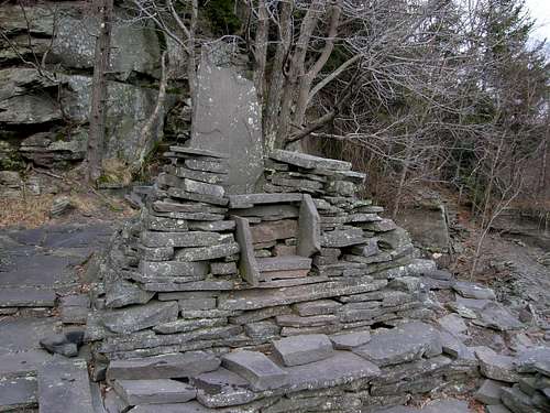 Stone Throne in the rock quarry area
 Moss covered cairn
 Moss covered boulder
 The Central High Peaks as seen from Sugarloaf
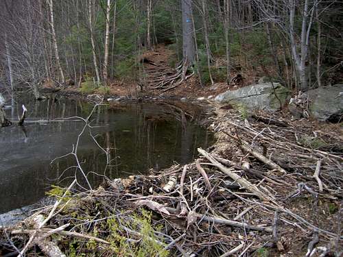 Beaver dam in the middle of the trail!