
-
 6232 Hits
-
 81.84% Score
-
 14 Votes
|
|
Mountain/Rock |
|---|---|
|
|
28.21830°N / 16.6923°W |
|
|
Hiking, Scrambling |
|
|
Spring, Summer, Fall, Winter |
|
|
7310 ft / 2228 m |
|
|
Overview
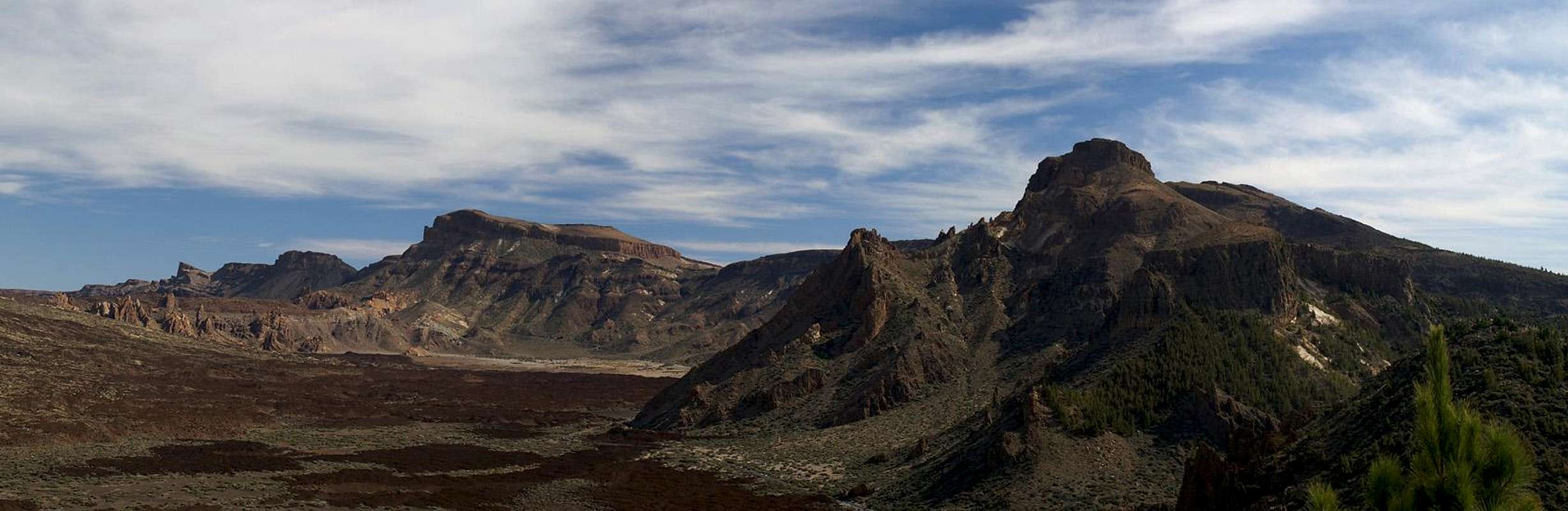
 Roques de Chavao seen from Boca Tauce Roques de Chavao seen from Boca Tauce |
To the western side of the huge crater of the Cañadas del Teide on the island of Tenerife you find a veritable lava desolation. In 1798 during the last eruption within the Cañadas the Narcises del Teide, a number of lateral craters on the slopes of Pico Viejo, vomited large amounts of cinder and lava, which covered the plains within the caldera of the Cañadas. The lava was stopped only right in front of the caldera wall - or what remains of it in that area. The wall itself has eroded into four separate mountains, all lacking the profundity of Roque de la Grieta or Guajara in the south but nevertheless worth a visit. In fact, I would say that the traverse across Roques del Cedro, Montaña del Cedro, Roques de Chavao and Montaña Gangarro is the most alpinistic of all routes in the Cañadas del Teide.
The most challenging mountain of the four is the one called Roques de Chavao. It has been named rather by the massive towers and spires which surround its summit on the caldera side than for its general appearance. Thanks to the erosion the main bulk of the mountain is somewhat rounded and hill like. But once you get close you'll find numerous walls and spires, some vertical, some overhanging. While the main part of the mountain is made up from sintered cinder scree its summit area is made up from basaltic blocks.
Thanks to these blocks the ascent to the highest summit of the Roques de Chavao is rather challenging. While much of the route has been marked either by cairns or by green markers, close to the summit you are more or less left to your own devices. There are basalt walls which block the way and which have to be circumvented. Orientation also is a bit tricky and the easiest route is not always obvious. Still, when finally on the summit, you have a perfect view of Teide and the Cañadas and especially the lava flows coming from the Narcises. In spring quite a lot of the 2m high Tajinaste del Teide bloom on the main summit of the Roques de Chavao. In winter, however only their skeletons remain. Take care not to touch them as they are covered in hair-like needles.
|


Summit Views
  |
Like from all summits of the rim of the giant caldera of the Cañadas del Teide you have great views all around. Naturally Teide and Pico Viejo, the highest mountains on the island draw most of the attention. Also, the huge crater itself is a stunning sight. To the north lies the desolation of Pico Viejo, an area which betrays its origin in a multitude of smaller volcanoes. To the north-west the lower Teno mountain range, one of the oldest areas of Tenerife can be seen and off the coast the islands of El Hierro, La Gomera and La Palma float in the sea.
|


Getting There
 |
As one of the major European vacation getaways Tenerife can be reached from all major European airports. From Spain there are regular flights from the rest of Europe you can book lots of charter flights. On Tenerife there are two international airports, one at Santa Cruz in the east, one at Los Abrigos in the south.
You can reach the Cañadas del Teide from all four directions. Just drive as far upwards as you can and you'll be there. From the south there is a road from the airport via Villaflor to the Cañadas, from the West you must head for Chio either from Playa de las Americas or from Santiago del Teide. The northern road starts from Puerto de la Cruz and the eastern ascent starts from the capital Santa Cruz del Tenerife and crosses the mountain range Cumbre Dorsal.
Alternatively you can take the bus either from Playa de las Americas (Line 342) or from Puerto de la Cruz (Line 348). Both buses depart at about 9:00 a.m., the return buses go around 4:00 p.m.
The trailhead for Roques de Chavao is at Bocca Tauce, the south western corner of the Teide National Park. There is ample parking space and a bus stop.
|


Red Tape
 The Cañadas del Teide seen during the ascent to the Roques Chavao
The Roques de Chavao are part of the "Parque Nacional del Teide" which is composed of a giant volcanic crater the "Cañadas del Teide" with 48km circumference. In fact the Cañadas were created by two craters which over the time (and due to erosion) blended into each other. The central range of the Roques Garcia formed the boundary between these craters and you can still see how the earth was tormented to form these bizarre rocks. To the south and west the crater walls of the Cañadas del Teide are still standing. They form a number of distinctive summits, the highest of which is Guajara at 2715m. The northern and most of the eastern crater walls have disappeared below the huge Pico Teide and Pico Viejo volcanoes.
Activities in the national park are limited as in every park. You are requested not to leave the trails - and from your own judgement - you shouldn't. The lava sometimes piles up to heights of 5 - 10m and makes orientation VERY difficult. Climbing is only allowed at the base of Guajara at the Piedras Amarillas. Also, camping is not allowed in the park.
Accommodation
Of course you can find a lot of hotels, fincas and casas on the island which you can book from any travel office. The Cañadas del Teide are a natural park so camping is not allowed. You might use the Parador Hotel which is supposed to be quite expensive, however. Better stay at one of the hotels at sea level and drive up by rental car or bus.Weather Conditions
There are several sites on the web which give you information on the weather on Tenerife. However, they all show the weather for the coastal regions (Puerto de la Cruz) which significantly differs from the weather in the Cañadas del Teide which are 2000m of elevation higher. The following table shows data for Puerto de la Cruz on the coast.| Month | Jan | Feb | Mar | Apr | May | Jun | Jul | Aug | Sep | Oct | Nov | Dec |
| Avg. day temp.[°C / °F] | 19 / 66 | 19 / 66 | 20 / 68 | 21 / 70 | 22 / 72 | 23 / 73 | 24 / 75 | 26 / 79 | 26 / 79 | 24 / 75 | 22 / 72 | 20 / 68 |
| Avg. night temp.[°C / °F] | 13 / 55 | 13 / 55 | 14 / 57 | 14 / 57 | 16 / 61 | 18 / 64 | 19 / 66 | 20 / 68 | 20 / 68 | 18 / 64 | 17 / 63 | 14 / 57 |
| Water temp.[°C / °F] | 19 / 66 | 19 / 66 | 19 / 66 | 19 / 66 | 20 / 68 | 20 / 68 | 22 / 72 | 23 / 73 | 22 / 72 | 22 / 72 | 21 / 70 | 20 / 68 |
| Rainy days | 10 | 7 | 8 | 4 | 3 | 2 | 1 | 1 | 3 | 5 | 7 | 9 |
The Canarian Islands (as well as Madeira) are located in the trade wind zone. You almost always encounter northeastern winds which carry a lot of humid air. Being forced to climb to higher altitudes this moisture condenses into clouds. This in return means that most of the time the northeastern part of the islands is covered in clouds from altitudes of 1000m through 2000m.
The mountains themselves - being mostly of the same altitude - finally stop the clouds so that on their southeastern slopes the clouds "run out". In the case of Tenerife the Cañadas del Teide are so high that rarely ever you encounter fog or clouds. This on the other hand means that the whole area is very dry so be sure to bring your own water.
Maps & Books
Out of the multitude of maps and books I have been using the following. However, so far I have not found a good hiking map of the island. The one posted here is ok but shows only a fraction of the marked hiking trails. The guidebook is excellent but be careful if you do any one of the suggested "variations" to the tours described therein. The variations are described in a few words only and you might get the wrong impression of their quality.- Maps
- Teneriffa
Kompass Map WK233
Kompass Verlag
ISBN: 3-85491-038-X
Books
- Teneriffa, Tenerife
K.Wolfsperger, C. Ade
Rother Walking Guide
Rother Verlag
English - ISBN: 3-7633-4809-3
German - ISBN: 3-7633-4016-5