-
 1702 Hits
-
 0% Score
-
 0 Votes
|
|
Route |
|---|---|
|
|
1.40691°S / 78.7534°W |
|
|
Overview
Getting There:
To get to Carihauzo, take a bus to Guaranda from Quito (Terminal Quitumbe). Have the bus driver drop you at the Chimborazo park entrance, 32 miles from Ambato towards Guaranda. There’s no official sign, just a turn off that can be easy to miss. Have the entrance pinned on Maps.Me. The coordinates are (01°23’02.2, 78°50,05.63″W).
(Note that there are several entrances to the park and the bus driver may insist you are on the wrong side because the Chimborazo Refugio is on the other side of the park and Carihauirazo is not a well trodden mountain.)
The Hike: Total Distance Round Trip: 14.4 miles Elevation Gain: 2,956 feet A decent wikiloc route can be found here. However, it doesn’t start until well into the hike and I cannot guarantee that this was the particular route we took up. Or that it’s even still possible to go this way with the lack of the glacier.
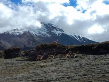
After getting off the bus you follow a wide dirt road. After about 2 to 3 hours you leave the road and make your way onto a trail through the grass. The trail can be hard to find because of all the animal trails but its on Maps.me and once you’re on it, the trail is pretty clear. The trail goes to the left of the big rocky outcropping that you can see from when you’re leaving the road. Camp past that rocky outcropping when Chimborazo reappears. There’s an old geological survey station that has a knocked over chain link fence. We camped a stone’s throw from that station where the ground was flat and we had a view of Chimbo in front of us and a view of Cari behind.
The next day you will follow the trail off to the left of the summit and then make your way up the talus. The trail is pretty clear. Make your way onto the mid mountain glacier then angle up for the notch in the ridge. The glacier is so small at this point it barely deserves that name, we were on it with no new snow and didn’t even put on crampons. Although if there were fresh snow we would have been glad we had the crampons.
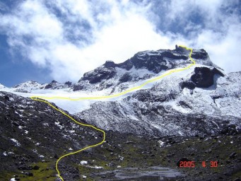
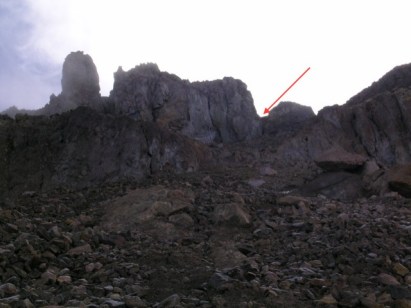
Above the glacier you go into a notch that leads to a 4th class chimney. If that chimney is dry then getting up it is no problem. An experienced climber or mountaineer would have little trouble free soloing it with a tag line due to the apparent safety of being tucked in the chimney. When we did it, the chimney was filled with snow and ice forcing us to climb the face just to the left of the chimney. That face would be a Yosemite 5.7 but is only 2 or 3 moves of climbing and is well protected. The biggest issue is the rock is loose in a lot of places so test your holds and wear a helmet. When we climbed this section was covered in a sheet of ice so we found it a bit more technical. It really is just the first two moves that are committing.
This hike requires crampons, ice axes, harnesses, rope and definitely a helmet. If there is little snow coverage, it also requires trad gear to get up on the last summit block. Don’t go unless you’re confident in your mountaineering abilities.
On a clear day the reward is as big as the mountain itself, from the top of Carihuairazo, all of Ecuador’s “Big Ten” peaks can be seen.
There are no entrance fees for this mountain. Don’t let anyone tell you otherwise.
As always, Look good, have fun, be safe. Good Luck!
External Links