
-
 36649 Hits
-
 77.24% Score
-
 8 Votes
|
|
Route |
|---|---|
|
|
37.09390°N / 118.5219°W |
|
|
Mountaineering, Trad Climbing, Scrambling |
|
|
One to two days |
|
|
"California Sierra Class 4 |
|
|
Class 4 |
|
|
III |
|
|
Approach
Drive to Bishop. From Bishop, take West Line street, which is signed for the South Lake Recreational Area. Drive the 22 miles to South Lake. The trailhead begins here. The pass is reached after about 8 miles.
Descend from the pass to a small tarn, then leave the trail, and begin hiking cross country, above the lakes of Dusy Basin to Thunderbolt Pass which is obvious in the distance. Several small cliffs need to be circumnavigated, try not to get too low into the basin.
Once Thunderbolt pass is reached, head down easy ledges to a perfect little camp site nestled among huge boulders on flat sand.
 |  |
Route Description
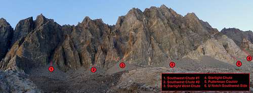
Westside Chutes as seen from the Palisade Basin
From the campsite. locate a series of big white cliffs to the right. The biggest chute between the 2nd and 3rd cliffs is the route. Slog up sandy talus, then onto cleaner rock about halfway up the chute. When the chute above begins to narrow to an overhanging coulior STOP.
To the left is a cliff with a dainty, well marked catwalk. It's not over conspicious, but if it looks exposed, you found the right one. As of Sept. 2005, cairns clearly marked the beginning of the catwalk. Head out, and slightly down on this catwalk, until reaching the very outside of the chute, and around the corner of the cliff.
Climb up 3rd/4th class ledges and cracks, then scramble over a small hump and up into a second chute. This chute narrows with short sections of stemming or face climbing to get past, when in doubt, stick to the left side of the coulior.
The second coulior ends in the famous 'bowl', with the summit within reach. Following the natural line straight up and left ends in a drop-off. Instead head for the boulders of the summit ridge up and right. The boulders must be hopped over, squeezed between, edged around, and in general just figured out, until suddenly the summit is upon you.
Descent: It's faster to rappel from the summit to the bowl than to repeat the boulder antics, then it's a straight shot down the coulior. Two short rappels are required in the coulior. The catwalk is actually a little easier on the descent.
 |  |  |
Essential Gear
A single 50 or 60 meter rope speeds up the descents, though competent parties shouldn't need it on the lead. The 4th class sections are surprisingly steep, but not sustained. Some extra webbing to replace the ratty anchors you might find is a good idea.
Miscellaneous Info
If you have information about this route that doesn't pertain to any of the other sections, please add it here.
GlennG - Sep 15, 2005 3:13 pm - Hasn't voted
Route CommentYour "as of 2001" description of the cairns marking the 4th class ledge system is still correct as of September 4, 2005 if you want to change it. We descended that route after traversing from Starlight over to North Pal. It was well marked and made for a much nicer alternative than wrapping down some hairy looking sections.
darinchadwick - Sep 21, 2005 2:20 pm - Hasn't voted
Route CommentMade the update, but I left your comments about the descent for others who may find it useful. Thanks, Darin.
Simkin - Dec 20, 2015 2:03 am - Hasn't voted
Incorrect coordinatesThe coordinates 37.09390°N / 118.5219°W actually mark the chute named Southwest Chute #2 ( http://images.summitpost.org/original/857913.jpg ) , not U Notch Southwest side. The directions "Once Thunderbolt pass is reached, head down easy ledges to a perfect little camp site nestled among huge boulders on flat sand." are very unclear. And combined with incorrect GPS coordinates outright misleading.
darinchadwick - Dec 22, 2015 2:43 am - Hasn't voted
Re: Incorrect coordinatesThanks. I'll look into it. Probably from an earlier version of Summitpost, and things havn't been corrected since. I'm sticking to the description of where to camp though, as there is really only one way to descend from the pass, and it's hard to miss. My point was that there is a place there to camp if you're looking to get a head start on the next day's climb. But yeah, for sure, gotta get the right coordinates in place. Thanks for catching the mistake.
frostbite36 - Sep 10, 2019 4:37 pm - Voted 6/10
Climbing SW Chute 30AUG-01SEP 2019My partner and I took three days total and I consider us a relatively fast/strong party as we are experienced and former Navy SEALs. We hiked from South Lake on FRI starting from trailhead around 3PM then heading up over Bishop Pass, turned south, crossed toward Thunderbolt Pass staying high on left side of Dusty Basin and scrambled up over Thunderbolt Pass to base-camp which was a pretty easy hike except for when we reached the boulder fields. We packed light as possible...no tent, minimum food. We hiked to Bishop Pass that night and laid up 1/2 mile into Dusty Basin. The next morning (SAT) we continued toward Thunderbolt Pass. The last 1/2 mile approaching Thunderbolt Pass and 1 mile past it was large boulder hopping and very slow. Do not lose any significant altitude between Bishop Pass and Thunderbolt Pass staying high on left side of the Dusty Basin Valley. Same applies on the other side of Tbolt Pass. We laid up a 1/4 mile North of base/entrance of the SW Chute in the boulders, left our camping gear. We headed up with day packs, 8.1mm climbing rope, and alpine climbing lead rack to protect and repel the 4th class sections at around noon of second day (SAT). We should have arrived at base camp a day earlier, but we weren't on the trailhead until late afternoon on our first day (FRI). This was a big mistake, time-wise. The SW Chute is very steep and mostly loose medium/large rocks over dirt & gravel. There are a few slabby areas to negotiate about 1/3 way up the chute. The chances of either human caused or natural rock fall is relatively high throughout the chute. You need to zigzag your way up to find the easiest/safest route for about 1000 vertical feet while in the sw chute from its beginning. There are several cliffs in the chute to move around on the way up. On the way down that night we heard several large rock-fall on the SW side of the mountain and we accidentally caused one ourselves despite being cautious. Being in this chute below another party would be relatively dangerous. Night was not too fun either as there are a few cliff areas to zigzag through along the way and it was a moonless night making it hard to see these until standing on the precipice. A GPS altimeter may not be super accurate higher up in the chute due to the walls blocking the signal, so our GPS track is not likely super helpful to others, unfortunately. A barometric altimeter will be accurate at least if reset at a known point like a pass or lake. We initially got off route by leaving the SW Chute at 13,000-13,100 feet at the wrong ledge heading left as described online and in some books (SECOR). This would turn out to be the wrong ledge (too low) or we did not traverse far enough left, we were looking for the one normally referred to as the "catwalk". We wasted a couple hours climbing straight up the wrong gully on class-5 terrain (looked easier from below) before finding, we believe, the left side of the proper catwalk ledge further above. Some route descriptions online and in Secor's guide to the Sierra state to leave the SW gully "half way up" SW Chute. Look for the catwalk traverse 8/10 the way up from the bottom of the SW Chute at closer to 13,200 feet. There appears to be a good video of the traverse here which I wish I had seen before: https://youtu.be/mxMo9QicG6o I did not see the Chute-side of this ledge start area myself as we retreated/repelled down the route we originally climbed (the wrong way). When I explored that way on what I believe was the catwalk ledge on the way down, it was already night (decending on headlamps) and because I didn't see an obvious way straight back to SW Chute at the end of the ledge, I decided to walk back across the ledge and rappel down the class-5 section because it was already known to us. There is a good picture of this ledge we were on here: https://cdn-files.apstatic.com/climb/106340134_large_1494099549.jpg It appears I should have climbed up a few feet continuing right on the exposed broken rock at far right end of ledge (catwalk) to get back into the SW Chute at the end of the ledge. Can anyone confirm? We decended down to camp that night and bivied out. The next LONG day (SUN) we hiked out and made it to trailhead at just before sundown. The last 2-3 miles were a bit miserable because we were exhausted. BTW, this is my last 14K peak in the Sierras I need to climb to complete them all. This was one of the hardest of them all via a standard route. We did not summit as we turned back right at sundown at 13,600 feet. We had wasted too much time off-route. Hope this helps others. Benny.
Mountain_Malcolm - Jul 1, 2022 12:33 am - Hasn't voted
ClarificationWhich chute in the photo of numbered chutes is the chute for the LeConte route?