
|
|
Route |
|---|---|
|
|
42.53690°N / 20.17090°E |
|
|
Hiking |
|
|
Spring, Summer, Fall, Winter |
|
|
A long day |
|
|
walk-up |
|
|
Getting There
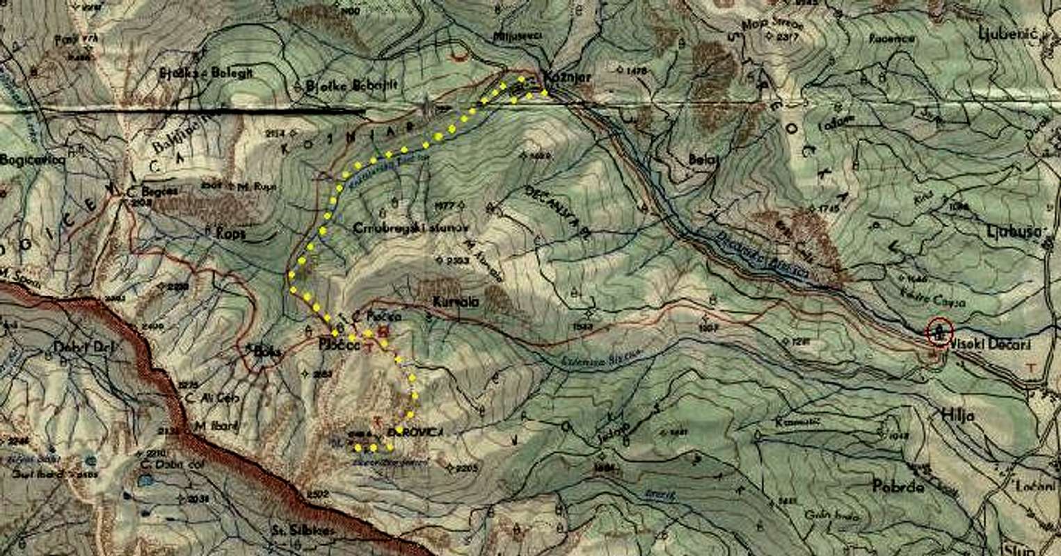
This route and another route described here share the starting point, which is the Orthodox monastery of Visoki Dečani. The monastery is easily accessible by a short asphalt road from Dečani. The nearest bigger town is Peć (Pejë in Albanian), 16 km north of Dečani.In summer 2005 you could get to the monastery and further into the mountains after registering at the military checkpoint guarded by Italian soldiers, open only at daytime. Because of unstable political climate in Kosovo the situation may change, though. The monastery is worth a visit for its beautiful medieval frescos. From the monastery it is another 7 km or so to the village of Kožnjar, also known as Belaje, by a dirt road, bumpy at places but easily accessible by car. About 1 km behind the monastery near the road there are places in the stream Dečanska bistrica where you can bathe although the water is quite chilly. At Kožnjar we saw only one house with a carpenters’ workshop by the main road. You can leave the car there after agreeing it with the locals.
Route Description
From Kožnjar walk further along the same dirt road. After a couple hundred metres it turns sharply right and then again left - on this second turning don't go straight on into a smaller path, you must go left with the main road. On the third hairpin turn don't turn right - go straight on into a smaller road. After another 1 km or so you cross the stream using the logs of an unfinished bridge (summer 2005 - may be finished by now). That is the furthest place accessible by car but I wouldn't recommend leaving a car there as nobody would keep an eye on it. Follow the bad road for logging tractors until you reach a big meadow called Rupa (The Hole) - ca. 2-2.5 hours from Kožnjar with a heavy backpack.Near the top end of Rupa look for the start of the old Yugoslav red-marked trail - it can be quite difficult to find. Just before the connection of streams on the left of the path there is a place in the forest that looks run down by woodcutters' tractors. From there a tiny, hardly visible path starts up a very steep slope. When you find the first red mark on a tree, you're at home. The marks are faded and easy to lose. Above the treeline the path flattens out a bit, you pass some shepherds' huts below on your right and then a spring with drinking water. Then you reach the Pločice saddle with another shepherds' settlement. Maybe that's the place where the Yugoslav mountain hut used to be - I'm not sure.
You don’t have to go down there, turn left instead. Follow the path up a grassy slope to a plateau (some water, good place for camping), cross a low ridge and you will see the top of Đeravica for the first time – go the obvious way to the summit – ca. 4 hours from Rupa.
You can walk down the other side to the north, take some shortcuts and join the path above Pločice.
This route is also described in this trip report.
Essential Gear
In summer - just good boots and the usual stuff. There is plenty of water most of the way so no need to carry too much.Haven't tried it in winter but near the summit you will probably be more comfortable with crampons.
Red Tape
As for summer 2005, you had to register at the UNMIK checkpoint (guarded by Italian soldiers) to get to Visoki Dečani monastery and further into the mountains. Apparently this presented no problem for foreigners. Because of unstable situation in Kosovo it may change, though.Camping
Above the treeline there is plenty of space for camping. We haven't talked to shepherds in that particular area but in general they are very friendly in Kosovo, Albania and Montenegro.Landmine danger
The locals warned us there may still be landmines in the area - go at your own risk.Here is another comment concerning landmines.