
|
|
Route |
|---|---|
|
|
43.52060°N / 122.1486°W |
|
|
Hiking |
|
|
Summer |
|
|
A long day |
|
|
class 2 /easy third class |
|
|
Overview
this route is very similar to the south ridge route but I belive it to be more scenic and possibly easier to navigate.Getting There
From Eugene take highway 58 east to Oakridge. About a mile outside of oakridge turn right on forest road 21 (also known as rigdon road or diamond drive. Follow this for 30 or so miles and turn left on forest road 2149. Do not turn on road 2160. Drive about a mile past the intersection and u should see a trailhead sign that says corrigan lake ( it will be on the right)Route Description

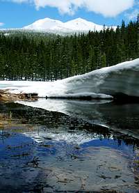
The trailhead is at 5000ft and gains 536ft to Corigan lake. The trail is 2 miles of switchbacks through a somewhat dense forest. It is possible to cut of 1 and a half miles if u go straight using compass and gps but i wouldnt recomend it unless u have good navigation skills. from corigan lake you get a good veiw of diamond peak. From here you will have to navigate using gps (bushwhack) it is about 1.5 miles and 1500ft of elevation gain until you pass the tree line. I headed directly north east. From here it should be easy to see where you're going. this is when you will have to scramble. If there is still snow on the mountain it is safer to hike on that so long as you can stop yourself if you slip. If there is no snow to climb on i found it was easier to stay to the left side of the ridge. The last distance from the false summmit to the true summit is 0.3 miles and gains about 700ft.
Essential Gear

for summer climbs:
mosquito repelent
compass/gps
I didn't wear a helmet when I climbed, but it would probably be safe
for winter climbs:
crampons/ snowshoes
ice axe
External Links
This is the ten day forcast for Diamond lake.http://www.weather.com/outlook/recreation/outdoors/tenday/061503:13