
-
 4097 Hits
-
 75.81% Score
-
 6 Votes
|
|
Route |
|---|---|
|
|
39.15750°N / 106.5212°W |
|
|
Hiking |
|
|
Spring, Summer, Fall |
|
|
Half a day |
|
|
Class 2+ |
|
|
Overview
Deer Mountain (13,761')Northwest Ridge
Difficult Class 2
9 miles RT
3000'
via North Fork Lake Creek Trailhead (13,780')
This is the easiest of Deer Mountain's three ridge routes, but don't let that fool you! The route still does require some pockets of class 2+ scrambling and the rock is not always entirely stable. The approach takes you through the beautiful North Fork basin with views of PT 13202 and some surrounding rugged unranked 13ers.
This route also makes a great starting point for a loop combination with PT 13736 and Mt Champion via a 3rd class ridge traverse.
Getting There
The North Fork Lake Creek trailhead is at 10,780' and is well signed from Colorado 82 just at the base of the first switchback up the east side of Independence Pass. This trailhead is approximately 2 1/4 miles from the winter closure gate.There is parking for about a dozen cars in the dirt parking area.
Route Description
The route follows the North Fork trail along the North Fork of Lake Creek high into the grassy basin above. Initially the trail seems like it is heading for PT 13202, but as it gets closer to the head of the basin it takes a right, crosses a grassy rib and contours below an unranked 13er to the base of a steep slope. The trail then switchbacks up this steep slope to a high tarn at approximately 12,400'. The views of PT 13736 from here are impressive. Hike around the lake and up to a saddle between PT 13300 and Deer Mountain at just below 12,500'.PLEASE NOTE: The trail is incorrectly indicated on Mt Champion Quad maps, the red line on the route map below is my line that follows the trail to the best of my ability.
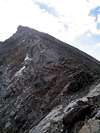
This is a good place to catch your breath as the steep ridge gains over 1200' on its way to the summit! The first part is the steepest and ascends semi-loose talus. Take it slow through here to find the more stable blocks. The ridge becomes more defined above and you will stay on or just to the right (southwest) of the ridge crest the entire way to the summit. The route is generally steep class 2 with a few pockets of class 2+ scrambling, especially on the ridge crest. There is some occassionaly dramatic exposure to your left as well.
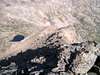
If you climb in the morning you will have the sun in your eyes the whole way up, and as a result pictures of the ascent don't come out too well. The overview picture is taken from near the summit and shows the tarn near 12,400'. This will give you a good idea of how steep the ridge is. There is also a picture that shows the upper part of the ridge that I took when the sun hid briefly behind some clouds.
 |  |
Essential Gear
Nothing special required in summer. Larger parties may opt for a helmet just in case, especially if travering to PT 13736.There is some prime avalanche terrain around the area, use extreme care when planning a winter visit. Keep in mind as well that the trailhead is 2 1/4 miles farther down the road in winter.
Route Map
Annotated Route Map below: Route Map