
|
|
Route |
|---|---|
|
|
28.86234°N / 90.13544°E |
|
|
Mountaineering |
|
|
Expedition |
|
|
5.0 (YDS) |
|
|
High altitude snow climb |
|
|
Overview
 1. Start walking up river
If the snow conditions are fine, this is a pleasant route to a nice little summit in a beautiful area. The gradient is up to 50 degrees, but the average is much lower. Probably about 35 degrees. I think the steepest parts were due to bulges of snow. Those sections are probably not that steep when the snow is gone.
The couloir that takes you to the summit is a little bit dangerous as rock falls can be quite frequent and there's a slight avalanche risk after snow fall.
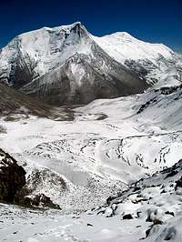
 2. The valley where Jietanzhouma can be seen
We set BC way too far away from the peak at an altitude of 4950m and from there it's a long 6km one way to the peak. Better set it in the valley where the peak is located.
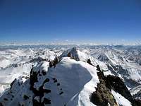
The views from the summit are excellent. Two Himalayan giants are close by - Noijing Kangsang and Kaluxung. Further away you can see Qungmoganze and some of the higher peaks in the central Himalayan range.
Altitude gain from BC - 1100m.
Getting There
 3. The route
See main page for details on how to get to the area.
 4. Looking down
In short: China - Xizang/Tibet - Lhasa - Nakartse - almost to Karo La.
Walk up the main valley leading south from the road just before the pass (Karo La). From the main road it's about 8 km to the peak. You walk for about 4 km along the valley and then you see another one leading west. In the end of this valley you see Jietanzhouma. Another 4km and you're at the foot of the peak.
Route Description
 5. High winds close to summit ridge
Look for the largest couloir on the east face. If you're lucky it's filled with good snow. In the beginning it's not steep and you may have to walk on some rock. It gets gradually steeper and peaks out at about 50 degrees at a short section close to the summit ridge. It has some small bends, which is good if you have to avoid rock falls.
Follow the path of least resistance.
When you're at 5950, hold right. If the snow is bad you can take help from the rock wall on your right hand side. Follow the steep rock wall until you hit a little basin filled with deep snow. You may have an overhanging cornice on the other side.
 6. Summit ridge
Climb it or hack you way through it. On the summit ridge go left/south. Watch out for the cornice which most probably always is on the left hand side. After about 50 meters you arrive at a small fore summit decorated with some thin lines.
Walk past it and aim for the end of the ridge. The last part is a little bit tricky as the ridge is very narrow and consists of very loose rock. Be careful here as the exposure is large and deadly. I built a very small cairn on the 6028m high summit.
Enjoy the views!
Essential Gear
 7. Summit
Very warm clothing. The winds can be crazy.
Crampons, ice ax and possibly a rope and some protection gear. Can be done without the two latter items, but you may prefer to bring it as the ridge is far from safe.