
-
 5587 Hits
-
 76.66% Score
-
 7 Votes
|
|
Route |
|---|---|
|
|
46.57078°N / 13.21672°E |
|
|
Hiking |
|
|
Spring, Summer, Fall |
|
|
Easy UIAA I climb and scramble |
|
|
Rating the Route (By Hiking Standards)

The notch below the summit
Difficulty by the Swiss Hiking scale: T5. The grading system for hiking and scrambling routes is here.
0. General: From Rudnigalm, 1612 m (Passo di Cason di Lanza is 1567 m) to 2279 m, exposition S. First easy hike-up over the meadows and over screes, then a short climb, finally again an easy ascent over a moderately inclined grassy and rocky slope. The ascent over the rocky part is not secured! The climbing sections are no harder than UIAA I, but require (especially on a descent) some care. Gear: Good hiking shoes and poles.
1. Effort: cca 730 m, 2 h 30 min.
2. Power: 3 - Medium (only a few places, otherwise easy)
3. Psyche: 3 - Medium.
4. Orientation: 1 - No difficulties (well marked).
Overview

Aip alpine meadow

Towards Passo di Cason di Lanza
The SW ascent is most suitable for hikers, who attempt to climb on Creta di Aip / Trogkofel from Passo di Cason di Lanza. But from any direction you reach the comfortable long-distance trail Traversata Carnica / Karnische Hoehenweg, you will be able to jump from it in one hour also on Creta di Aip / Trogkofel.
The numbers above (start altitude and time) refer to Rudnigalm starting point, but the time from Passo di Cason di Lanza is much the same, as you don't go around the mountain. For the visitors who ascend the summit from the Austrian side, or by Ferrata Crete Rosse, the SW route is mostly used for the descent. Ascending Creta di Aip / Trogkofel you will very likely do a round tour. If you opt to descend by the normal SW route, then the Uiberlacher Weg is the recommended ascent route. If you opt to try the Crete Rosse ferrata, then it is better to choose that one for the ascent and descend by Uiberlacher Weg if you go on the Austrian side, and by the SW route if you go on the Italian side. I have still no personal experience with the West ridge route.
Route Description

The S plateau
Approaches:
a. From Rudnigalm, 1612 m, we continue by the road southwards, then we deter right, following the marks (Trogkofel, No. 413). The path goes over ski slopes, crosses a humble side ridge and descends on the other side into a broad valley, going among big rocks and boulders. We reach almost 1900 m, just below the E wall of Creta di Aip / Trogkofel, where the key crossword is. Towards the right goes the Uiberlacher Steig, but we continue left on the saddle, where we hit Traversata Carnica / Karnische Hoehenweg. The main ridge can also be reached by ski slopes (even easier and shorter).
Continue by the broad path below the southern walls of Creta di Aip / Trogkofel, pass the entry of Ferrata Crete Rosee, until from the left the marked path from Passo di Cason di Lanza comes up. There up towards the summit also the SW route deters. The approach to rocks is short.
b. From Passo del Cason di Lanza, 1560 m. You follow No. 439, a good, marked trail. From the road pass go eastwards, cross the creek bed and continue through the woods and grassy plains to Val Dolce hut and 10 min further by the road till the fist curve (1735 m). 45 min. There deter left (towards the east) and go by rocky and grassy channels and over small saddles, all the time ascending towards Trogkofel / Creta di Aip. On 1930 we hit Traversata Carnica (No. 403). For the summit ascent entry go just a few more meters towards the east. 1 h 20 min from the road pass.
Summit ascent:
After branching off from Traversata Carnica, the trail No. 416 already 20 m higher attacks the southern walls of Trogkofel / Creta di Aip. Over the rocks and debris we climb straight, then right, traverse left where we climb two stretches of UIAA I (30 m), climb left by a ramp, where we even find an iron hold for security. After another climb towards the left we enter a 10 m channel (UIAA I, iron hold) and then over the final rocks and debris we exit the S wall on some 2100 m.
After the next more gentle ascent we pass through a rocky bottleneck and find ourselves on the broad, karstic summit plateau. The trail ascends gently towards the NE, on the trail junction 2160 m we keep right, overcome some summit sock steps and reach the notch 2240 m in the W ridge. From there we go right on the traditional East summit. 1 h 10 min from Traversata Carnica (from point 1930 m).
The Map
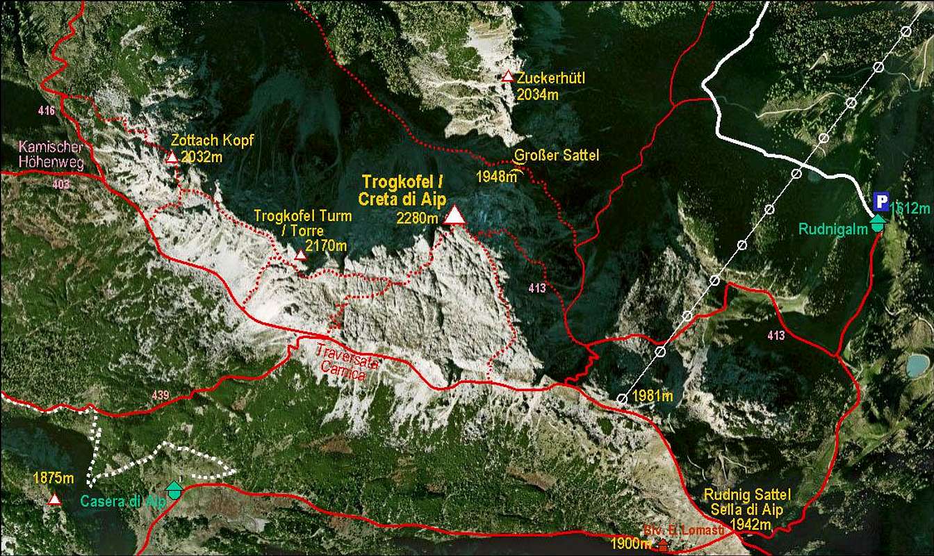
Creta di Aip / Trogkofel and its marked routes