
-
 4076 Hits
-
 78.17% Score
-
 9 Votes
|
|
Route |
|---|---|
|
|
42.10403°N / 118.70744°W |
|
|
Hiking |
|
|
Spring, Summer, Fall |
|
|
Half a day |
|
|
Class 2 |
|
|
Getting There


West Pueblo is located in extreme southeast Oregon between Fields (where you can buy their World Famous Shakes and Burgers) and Denio in northern Nevada along highway 205. About 12 miles north of the NV/OR border on hwy 205 is a gravel road going west up Arizona Creek. This is about 1 mile south of the road to White Horse Ranch which is signed.
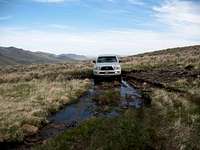
If it has been raining, don’t even try to drive this road because it turns into that snotty slippery gumbo mud that is slicker than ice. If you have chosen the right day to try this approach, drive west up Arizona Creek. At about 2.2 miles you cross Arizona Creek which has been on your left. At 2.8 miles make a sharp switchback uphill to your right. Now just keep on this main track all the way into Ten Cent Meadows. The road is skinny and rocky in places and then there are some water features to cross that seem to have solid bottoms. At 7.0 miles, elevation 7,000 ft, you can stop if you want to climb Pueblo, which is on your left. Otherwise, continue on down the hill.
At 7.8 miles turn right and then at 7.9 miles turn left up the hill towards West Pueblo. There are several campsites on this hill, but stay on the main track and keep going up. Go over a flattish hill at 8.5 miles and then drop down to the saddle below where the road ends at 8.6 miles, elevation 7,050 ft. I walked from the 7.0 mile mark because my partners wanted to do Pueblo. My ride drove over to this saddle and picked me up when I was done.
Route Description

West Pueblo can be done the same day as Pueblo if you are motivated and you can drive in to the Ten Cent Meadows that lies between the two. Once in Ten Cent Meadows, the route up to the summit is easy to find. There is no trail, it is almost all cross country Class 2.

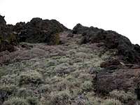
From the parking area in the saddle at the base of steep escarpment climb directly up the slope ahead of you. Elevation at the saddle is about 7,050 ft and you have to climb up to the ridge at elevation 8,150 in about .65 of a mile. There is nothing technical about this part of the climb, it is just picking your way between the rocks and small brush. You will see an easy nontechnical slope to follow to get up on the top of the ridge. Once on the ridge, you will be able to see the summit off to your right. Look around and note where you came up to the top of the ridge so you will be able to find the same spot on your way down.
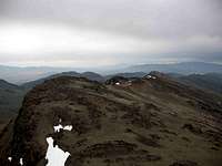
The summit is a large blocky rock area with vertical walls facing you. Don’t despair, head directly towards it and aim at the area in the middle with a small alluvial fan coming down. Just traverse along the escarpment without trying to gain or lose elevation until you reach the summit block. Climb this alluvial fan and go behind a separate fin of a rock that was blocking the view of the climbing route. At the top of the fan, you have to do a little scrambling that may be Class 3 for about 30 feet to get on top of the summit block. Once on top, look around and note this spot so that you can find it on the way back down. It isn’t real obvious.
Now that you are on top of the summit block, you have to find a route up to the highpoint and out to the edge of the escarpment. There seems to be several routes, but also brush and rocky areas to avoid. Pick your route and ascend the last couple of hundred feet to the summit. From the saddle at the foot of the escarpment this hike is only about 2.5 miles round trip with 1400 ft of elevation gain.
Essential Gear

The 10 essentials are always required. Hiking poles help on the steep descent back to the saddle. Take all the water you need, because there is none on the route.