
-
 6943 Hits
-
 91.39% Score
-
 35 Votes
|
|
Route |
|---|---|
|
|
34.94224°N / 101.69237°W |
|
|
Hiking, Scrambling |
|
|
Spring, Summer, Fall, Winter |
|
|
Overview
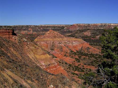 Capitol Peak from Capitol Mesa
The Lighthouse is the most recognizable symbol of the Llano Estacado. The trail to the giant hoodoo is one of the finest hikes in Texas, passing by colorful badlands formations, towering cliffs and additional, smaller hoodoos. However, such a trail does not go unnoticed, especially in this part of the country. Moreover, as scenic as the trail is, it generally stays a fair distance from the fascinating formations that distinguish the Palo Duro Canyon. A cross-country hike across Capitol Mesa is an excellent option for bypassing the normal Lighthouse Trail. By exercising this option, one is able to escape the crowds that may be hiking the normal route to the Lighthouse, as well as get excellent 360-degree views of the canyon. This route also provides a much more intimate exposure to the beautiful badlands and hoodoos seen from a distance along the main trial. If so desired, combining the two routes can assemble a great loop. This page will describe the trip to the Lighthouse via the normal hiking route separately from the cross-country trail via Capitol Mesa. The purpose for this is to make this page as useful as possible, assuming that many will simply want to hike the normal route straight to the Lighthouse.
Route Description
Lighthouse Trail
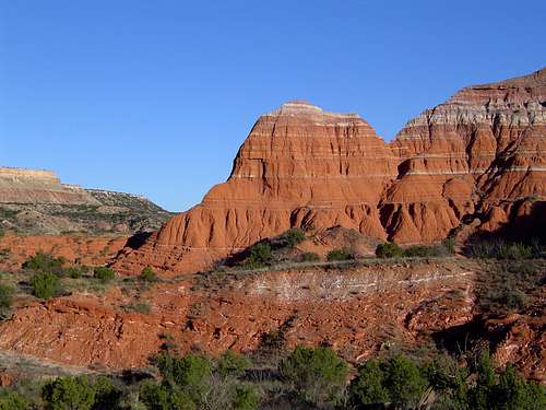 Badlands at the base of Capitol Mesa. Seen from the Lighthouse Trail
The regular trail to the Lighthouse is a fairly straightforward 6 mile round trip hike. Other than a short, steep climb up to the base of the Lighthouse itself, the trail has very little grade. From the parking lot the trail travels due west, toward Capitol Peak. Some displays and covered sitting areas line the trail early on. The trail forks at 0.5 miles. To the south is a loop trail that in Capitol Peak Canyon. This is a popular mountain biking route and is also the beginning of the way one ascends Capitol Mesa. Stay to the right to continue on the trail to the Lighthouse. From the fork, hike north, rounding the northern flanks of Capitol Peak and eventually turning west again.
The trail passes some excellent badlands formations. Their bright red and yellow color adds a lot of visual appeal to the trail. To the north is Timber Mesa. The Fortress Cliffs tower ominously to the east. The trail begins to follow the bed of normally dry Sunday Creek. Eventually the route turns south and the Lighthouse comes into view in the distance, 1.5 miles from the trailhead. The cliffs of Capitol Mesa rise directly above the trail. Small rocky pinnacles and hoodoos are visible on its slopes. Though it is nearly imperceptible from the trail, the route leaves the Sunday Creek drainages and continues along Little Sunday Creek, periodically climbing in and out of the normally dry creek bed.
 Little Sunday Creek and Capitol Mesa from near the Lighthouse
As one approaches the Lighthouse, the trial steepens considerably and several use trails branch off of the main route. Though these all lead up to the bench that the Lighthouse rests upon try to find one that has less erosion issues. Once upon the bench, the giant hoodoo remains quite imposing. South of the tower is a short butte upon which one can climb for the best view of the Lighthouse.
From this point one can return the way one came back to the trailhead or hike back via the Capitol Mesa route. Though this is a reasonable option, it is probably preferable to hike to the Lighthouse via Capitol Mesa and then return on the Lighthouse Trail. The reason is the more time consuming and interesting route (via Capitol Mesa) is capped by a visit to the Lighthouse and then the return to the trailhead is more direct than returning the way one arrived. Although the loop is an easy possibility, this page will describe only the Capitol Mesa route from the trailhead to the Lighthouse.
Capitol Mesa Route
 Fortress Cliffs from the ravine accessing the top of Capitol Mesa
Begin the route along the same stretch of trail that began the Lighthouse Trail. After 0.5 miles turn south at the fork. Mountain bikers frequent these paths so remain wary of their presence. The trail passes beneath Capitol Peak. A fine hoodoo is visible on its southeastern flank. Stay on the path for 0.2 miles and then strike out west, traveling cross-country toward a large ravine. This should be the first large ravine after the saddle between Capitol Peak and Mesa. Hike up the ravine to the flat summit of Capitol Mesa. Great views are available in all directions. Game trails abound on the top of the mesa and make travel easy. Follow the spine of the Mesa southwest. If the plan is to reach the Lighthouse, the best option is to hike all the way to the point where the mesa top begins to but up against cliffs of the canyon wall. While it is possible continue on to the massive pinnacle from here, skirting Castle Peak in the progress, it is easier to descend one of the numerous ravines back down to the Little Sunday Creek drainage. Go due west to intersect the main Lighthouse trail.
Map
 Lighthouse Loop