
-
 3070 Hits
-
 74.01% Score
-
 4 Votes
|
|
Route |
|---|---|
|
|
49.90639°N / 126.48722°W |
|
|
Mountaineering, Trad Climbing, Scrambling |
|
|
Summer |
|
|
Half a day |
|
|
5.4 (YDS) |
|
|
III |
|
|
3 |
|
|
Overview
 Mt Grattan east ridge Mt Grattan east ridge |
Access from Shangri La Lake via the prominent snow couloir on the south flanks of Thumb Peak and walk across to the 200 metres summit block from there.
Three exposed pitches up to 5.4 with poor protection lead to the summit.
Getting There/Approach
The east ridge route on Mt Grattan is best approached from Shangri La.From any point on southern Vancouver Island, drive north on the Island Highway 19 to Campbell River. From Campbell River take highway 28 west through Strathcona Provincial Park and onwards to Gold River. Just before entering the town of Gold River, watch for a right turn signed for Tahsis. It’s immediately after the tourist information office. Proceed 2 km on this road and across the bridge over the Gold River. Here the road splits. Right to Woss and left to Tahsis. Note this point on your odometer and turn left onto “Head Bay Road”. The pavement ends almost immediately, but this is good sealed or gravel road.
Drive about 27 km from the Gold River bridge and find Conuma Main on the right just after crossing the Conuma River. Drive this good main line about 11.5 km, passing the C15 access for Conuma Peak after 3.5 km and park at about N49 52.403 W126 24.954. The route to Shangri La Lake via the Conuma River approach starts here. Mt Bate towers above you to the northwest.
From the start point travel west and then follow the river north up the steep sided canyon. The route has been recently (July 2010) flagged. Beware of a dangerous river crossing at N49 52.753 W126 26.725. A ramp at N49 53.766 W126 27.450 is used to bypass a waterfall about half way up the canyon. Travel time to Shangri La 6-8 hours.
OR
Do your bit to mininise impact on the delicate and fragile ecosystems in the Sanctuary and consider an air assist in this case in order to remove all (and I mean all) evidence of your having been there.
Route Description
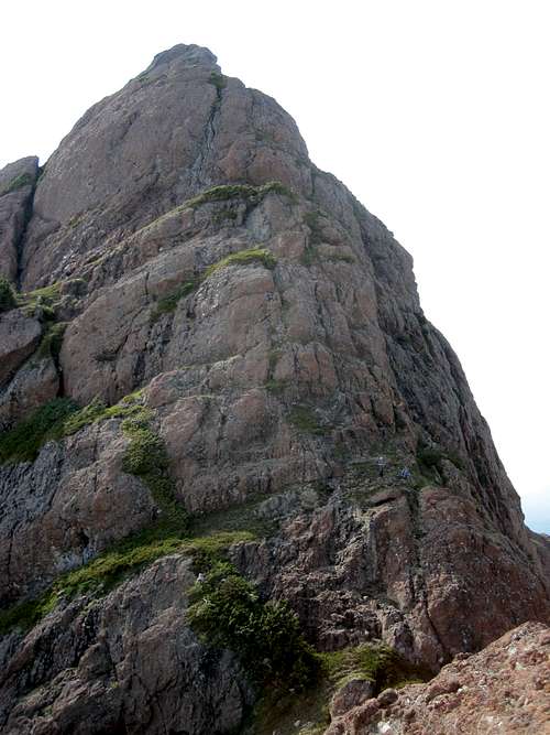
Approach from Shangri La Lake by climbing due west up the steep snow couloir on the south flanks of Thumb Peak.Traverse the col between Thumb and the ridge to the south directly to the base of the imposing summit tower of Grattan.
 East ridge route access East ridge route access |  Approaching the east ridge Approaching the east ridge |  First belay First belay |  Second belay Second belay |
Climb the steep ridge crest in 3 pitches, each of about 50 metres, with wide heather ledges between each. The first pitch in no more than 4th Class whilst the second and third present several thin and exposed passages. Protection throughout is poor.
At the top of the last pitch a short lay-back slab above a chock stone cave presents the last difficulty before a final Class 3 scramble to the summit.
 Short layback pitch Short layback pitch |  Approaching the summit Approaching the summit |  Mt Grattan summit Mt Grattan summit |  First rap station First rap station |
The actual summit is a tiny fin with room for one only but directly below is a nice wide platform for handshakes, lunch and photos.
A subsidiary, lower summit lies 20 or 30 metres further west if you want to scramble over there and bag that too.
Descend by down climbing or by rappel.
 First rap First rap |  Second rap station Second rap station |  Third rap Third rap |  Descending access gully Descending access gully |
Three permanent rap stations – new slings with rap rings - are currently (August 2010) in place. The first is just below the chock stone cave on a prominent horn. The second uses a bollard-like feature and the third is well wound around a clump of krumholtz. The last two raps start from the friendly heather ledges you encountered on the way up.
Route summary:
Distance: ~ 3 km
Net elevation gain: ~ 450 metres
Total elevation gain: ~ 475 metres
Approximate time: as short as 4 hours return for small parties. Up to double this for larger parties having to rappel.
As always a Garmin/Mapsource tracklog is available for the approach and climbing route on Mt Grattan. Just ask for it via an email or PM.
Essential Gear
Ice axe recommended for the approach couloir.Two 2 x 60 metres ropes to avoid shorter rappels.
A good selection of tape and slings to sling horns and in case the rap stations need renewing.
A small rack of medium to large pieces but don’t count on finding too many placements.
Red Tape/Safety Considerations, Weather, Additional Information/Suggested Reading,
Please refer to the parent mountain page.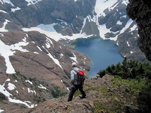
Looking down the east ridge