
|
|
Area/Range |
|---|---|
|
|
40.20198°N / 115.49289°W |
|
|
6000 ft / 1829 m |
|
|
Overview

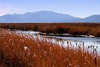
Located at 6,000 feet elevation along the eastern edge of the Ruby Mountains in northeastern Nevada, the Ruby Lake National Wildlife Refuge (NWR) comprises 39,926 acres, 17,000 of which are marshlands. The marshlands are the remnants of prehistoric Ancient Lake Franklin, estimated to have a surface area of 470 square miles and depth in excess of 200 feet. Surrounding the marshes are nearly 23,000 acres of meadowlands and grasslands, alkali playa, and shrub-steppe uplands. More than 200 springs from the slopes of the Ruby Mountains provide sustaining water to the marshlands.
 |
 |
 |
The Ruby Lake refuge was established in 1938 and belongs to a network of 548 refuges across the United States managed by the U.S. Fish & Wildlife Service. There is a gravel auto tour route with several access points that winds through much of the central marshlands. The refuge is open from 1 hour before sunrise until 2 hours after sunset.
More than 200 species of birds, including the once-endangered trumpeter swan, are regular visitors to Ruby Lake. The South Marsh provides some of the best nesting habitat west of the Mississippi River for canvasback and redhead ducks. This area has the highest density of nesting canvasbacks in North America. Bald eagles, golden eagles, owls, red-tailed hawks, and American kestrels are among the raptors present at Ruby Lake.
Other wildlife at Ruby Lake includes coyotes, mule deer, badgers, weasels, muskrats, black-tailed jackrabbits, mountain cottontails, pygmy rabbits, Great Basin rattlesnakes, and gopher snakes.
 |
 |
 |
Getting There
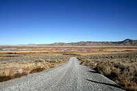
The two main routes to Ruby Valley NWR involve traveling between 23 to 35 miles on gravel roads, depending on which route you take. Please be aware that much of the country on the east side of the Ruby Mountains is ranchland and there are areas of open range, so drive with caution.From the west side of the Ruby Mountains: From Nevada Highway 227 southeast of Elko, take NV Hwy 228 at Spring Creek and proceed south. After 26.3 miles on NV 228, you will pass through the very small town of Jiggs. About 4 miles south of Jiggs, NV 228 will turn into Harrison Pass Road (County Road 718). After 39.2 miles from turning onto NV 228, the road will turn from paved to gravel before going through Harrison Pass. At the 42.3-mile point from the start of NV 228, you will pass by the old Star Tungsten Mine, which was destroyed by a fire in February 1943. Old mine houses are to the right of the road while the mine ruins are to the left. After 43.6 miles from the start of NV 228, Harrison Pass Road will intersect with Ruby Valley Road (County Road 788). Turn right and proceed south; you will see the first of several refuge access roads to the left after about 4 miles, then the historic Bressman cabin 2 miles later on the left; the visitor center is to the right 8 miles after the turn onto CR-788.
NOTE: The road through Harrison Pass is not maintained during the winter months, making it impassable during periods of heavy snowfall.
From the east side of the Ruby Mountains: From Interstate 80, take U.S. Highway 93 (exit 352) south at Wells then turn right (west) onto NV Highway 229 about 30 miles south of Wells; or, from I-80, take NV Highway 229 (exit 321) south between Elko and Wells. Continue south as NV 229 ties into NV 767. After about 2 miles, NV 767 becomes Ruby Valley Road (County Road 788) and goes from paved to gravel. Continue south on Ruby Valley Road to the refuge.
 Star Tunsten Mine, Harrison Pass. Star Tunsten Mine, Harrison Pass. |
 Bressman cabin. Bressman cabin. |
 One of several access roads to NWR. One of several access roads to NWR. |
Camping
There is a Forest Service campground located adjacent to the refuge 2 miles south of the visitor center.Red Tape
The refuge is open from one hour before sunrise until two hours after sunset.The visitor center is open from 7:00am to 3:30pm Monday through Friday; telephone number is 775-779-2237.
ATVs and snowmobiles are not permitted. Non-motorized or electric-powered boats are allowed from June 15-July 31; power boats under 10 horsepower are allowed from August 1-December 31.
Food & Lodging
This area is very remote. The small cities of Elko or Wells, about 1.5 hours driving time, would provide the best options for food and lodging. I’m not too familiar with Wells, but Elko, though not large, is significantly larger than Wells and would have more options.There are a number of hotels in Elko. I think the best deal in town is at the Stockmen’s Hotel and Casino. As of July 2007, a room with two twin beds went for $39.50. The rooms have AC, refrigerator, bathtub, hairdryer and many have a balcony. The hotel has a nice swimming pool and food is available 24/7 (including 24 hrs. breakfast) in the casino’s restaurant located right next to the hotel lobby. The Stockmen’s is located at 340 Commercial Street in Elko; 775-738-5141.
The Commercial Casino (775-738-3181) is right across the street from the Stockmen’s and their restaurant (the Brand Room) has a great dinner buffet Tuesday through Saturday, 5pm-10pm.
For good Sonoran-style Mexican food, try Sergio's on Idaho St. (between 8th and 9th Streets) in Elko. I've also heard that Sergio's serves the best burgers in the area, but have not tried them. Be careful when ordering as the serving sizes are large.