
|
|
Mountain/Rock |
|---|---|
|
|
35.14672°N / 74.62013°E |
|
|
Northern Areas |
|
|
Mountaineering |
|
|
Summer |
|
|
18510 ft / 5642 m |
|
|
Overview
Rupal Peak is located on the southern side of the Rupal Valley which is more famously known for the Rupal Face of Nanga Parbat, the highest face in the world extending over four vertical kilometres from the floor. Rupal Peak is not too difficult to climb and is ideal for someone looking for an introduction to climbing in the Asian ranges. It mainly involves climbing on snow slopes with a few short sections of easy ice. It could be compared to the Group B Trekking Peaks in Nepal for difficulty yet receives a fraction of the climbers and requires no red tape to climb, unlike Nepal.Rupal Peak is located in the far Western aspect of the Himalaya in Pakistan’s Northern Areas. It lies just 9km from the Pakistani province of Azad Jammu & Kashmir to the South-West and the 42km from the Indian Province of Jammu & Kashmir. Despite its relatively sensitive position the mountain is easy to visit from Gilgit, the largest settlement in the Northern Area. Rupal Peak can first be viewed a short distance west of the village of Tarashing, which is the gateway to the Rupal Valley. From this perspective the mountain is dwarfed by Nanga Parbat but beyond the Bazhin Glacier, which flows from Nanga Parbat's Southern Face, Rupal Peak's impressive Northern face come in to view.
Rupal peak was first climbed in 1964 and has received a steady stream of climbers ever since. The peak is either 5584m or 5642m depending on which map you refer to. A number of routes are possible with the Western route being the most popular due it being the easiest with minimal objective dangers. The climb involves short sections of WI3 but is generally easy. Undoubtedly the most famous climber to have ascended Rupal Peak is Doug Scott. He climbed the peak while in the Rupal Valley in 1986 along with Alistair Reid, Michael Scott, David Marshall and Nazir Sabir. They approached to the summit from the West side making three bivouacs on route. More direct summits can be made via the north face or NW couloir. The former may be subject to avalanche risk while the latter is subject to rock fall (see 1997 German expedition report).
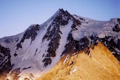 Rupal Peak in the shadow of Nanga Parbat's Rupal face
Getting There
 Rupal Peak (left) as viewed from base camp. In the foreground is the glacier that must be traversed before ascending the clearly visible icefall
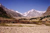 Small peak close to the Mazeno Pass at the head of the Rupal valley
Travel to the Northern Areas
Islamabad is the nearest international hub with flighs arriving from around the world. Gilgit is the largest town in the Northern Areas served by regular transport from the north and south.
Domestic flights
PIA fly daily between Islamabad and Gilgit and tickets can either be booked via their ticket offices or via their website. One-way fairs are currently Rs1590 with little discount for return trips. During bad weather planes may be grounded at short notice. There are also daily flights to Skardu which operate a higher percentage of the time.
Buses
Buses run daily between Rawalpindi's Pir Wadhai bus station and Gilgit, and vice versa. Buses leave throughout the afternoon and arrive mid-morning next day. Book tickets in advance if possible to avoid a bone jarring, sleepless ride on the back seat. Travel along the KKH is anything but predictable and landslides, mudslides, rock fall and even avalanches can sever it for hours, days or weeks at a time. Due to Tribal tensions in the Kohistan buses were travelling in convoy for a significant stretch of the journey further lengthening an already long journey. NATCO and Masherbrum both run buses daily with a limited number of seats available at student discount.
The Northern Areas can also be reached from China with the trip from Kashgar to Sost taking 2 nights with an overnight stop in Tashkurgan. Hi-Ace vans ply the route between Sost and Gilgit throughout the day leaving as soon as they are full.
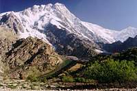
 Rupal Peak's Northern face viewed from the Rupal valley
Travel to the trailhead
Tarashing is the gateway to the Rupal valley. To reach Tarashing take a passenger jeep to Astor that leaves daily from the Jaglot bus station on the Domyal link Road in Gilgit. From Astor there are connecting jeeps to Tarashing. Gilgit-Tarashing special hires can be arranged for about Rs2500. Travel to Tarashing takes the best part of a day; maybe longer as rockslides between Jaglot and Astor are frequent (or even temporary closure of the road).
Trekking route
From Tarashing a shepherd trail leads west up the Rupal valley. It's a two day trek to base camp overnighting at either of Nanga Parbat's base camps. West of the Bazhin glacier there is an excellent view of Rupal Peak's Northern face. Further west, before the Toshain glacier, a valley joins the Rupal valley from the south. Turn south in to this valley then immediately start climbing its left side. The steep 1000m+ ascent through grazing slopes eventually leads to the arid surroundings of Rupal peak's base camp at approximately 5000m. The summit is not visible until ten minutes walk of base camp.
Red Tape
 Nanga Parbat from Latabah camp on route to Rupal Peak
Permits
No permit is currently required to climb under 6500m in Pakistan. This region is not in a restricted zone so no trekking permit is required.
Visas
A valid visa is required. Visas are NOT issued at the airport and must be obtained prior to arrival. Some embassies such as those in Central Asia are reluctant to issue visas and advise you to obtain them from your home country. A single-entry tourist visa is valid for 3 months from the date of arrival in Pakistan and for 6 months from the date of issue. Some visas are only valid for 3 months from the date of issue so check if necessary when applying. Visa prices vary. Americans pay the most for their visa whilst Japanese get theirs free! Visa extensions and re-entry stamps used to almost impossible to obtain however the process has become remarkably easier in the last few years. Gilgit DC is a good place to try.
When to Climb
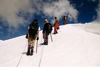 A short climb from the summit
The mountaineering season starts from late May and finishes by September. July and August are considered the best months to climb in Pakistan. Outside these months snow can be problematic at high altitude.
Climbing Conditions
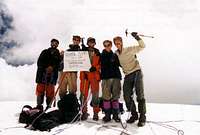 The Summit! Hunza hats at the ready.
For many people visiting Pakistan's Northern Areas for the first time the warm summer's take time to adjust to. In Gilgit time temperatures regularly stay in their 30s during the summer and whilst it is cooler in the mountains it can still be uncomfortable at times. On days where there are no clouds a single layer will suffice and measures need to be taken to prevent sun burn. Weather can change quickly with fresh snow falling at any time in the year or heavy rains at lower altitudes. Come prepared for a range of climates.
Nights are generally warmer during the climbing season compared to destinations such as the Pamir, Tian Shan or Nepalese Himalaya and an early start when climbing is usually imperative to avoid soft snow in the afternoon.
Camping and Accommodation
 Rupal Peak base camp overlooking the Toshain (Rupal) glacier
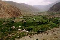 Tarashing village viewed from a hilltop to the west
 The Chongra ridge line above Tarashing
Camping
There are no camping fees in the Rupal valley and camping spots are numerous. The camping area at Rupal Peak's base camp is flat and suitable for a small expedition. Water is located nearby although this becomes a trickle in the morning. There are no suitable camping spots between the valley floor and base camp so previous acclimatisaion may be required due the rapid gain in altitude.
Camping Fuel
Kerosene is widely available in bazaars and can often be found in smallers villages. Pakistani kerosene burns sootily so be prepared to clean your multi-fuel stove regularly. White gas is not available and denatured alcohol is available only in Rawalpindi and Islamabad.
Gas stove cannisters are sold in the outdoor shops on Gilgit's main high street. They are often refilled so don't expect the usual butane/propane mix. They are generally available in sufficient number for a medium sized expedition.
Food Provision
There is no need to bring food supplies from your home country as sufficient provisions can be found in Gilgit. Grocer shops sell staples such as pasta, dal, rice and porridge. Fresh fruit is of poor quality in Gilgit and likely to turn to mush in your rucksack before even reaching base camp. Dried apricots and mulberries and readily available and make for a good snack.
Accommodation
Gilgit has a wide selection of hotels and guesthouses. The Madina guesthouse (NLI Chowk) is a personal favourite due to the warm reception I receive every time I visit. It's possibly my favourite place of stay anywhere! Those looking for an upmarket hotel need look no further than the Serena Hotel on a hill top on the outskirts of town. This is the town's only real 4-star hotel. Excellent food is also available (don't miss the buffet if it's on).
Map of Gilgit
Accomodation is available in either Tarashing or Astor. In Tarashing the Nanga Parbat Tourist Cottage and the Hotel Nanga Parbat both offer singles and doubles. You can also camp in the gardens if you're really on a shoestring.
Guides and Porters
A number of guides in Gilgit have climbed Rupal Peak although many compare poorly with western guides with minimal knowledge of techniques such as crevasse rescue. Prices are often attractive making however. Porters can easily be hired in Tarashing. Ask at the guest houses.Maps
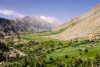 The Rupal Valley. Rupal peak rises in the middle of the photo on the left side of the valley
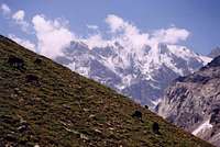 Chitta Katha Sar (I think) to the south.
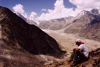 View west to Toshain (Rupal) glacier during the long ascent to Rupal Peak's base camp
US AMS 1:250,000 topographical map for Gilgit (NI 43-2) also covers the region however it is fairly inaccurate.
Alpenvereinskarte 0/7 Nanga Parbat/Astor topographical map (1:50,000). This unfortuantely does not show the south side of the Rupal valley.
There is also a rare German map (1:50,000) produced in 1936 however this is close to impossible to find
Basic online map showing the main peaks along the Nanga Parbat massiv. Unfortunately it doesn't show peaks the the south side of the Rupal valley. Website in French.
Map of Gilgit
General map of Pakistan
Map Stockists
UK
The Map Shop
Stanfords
Cordee
USA
Chessler Books
Map Link
Omni Resources
Germany
Aree Gaul
Deutcher Alpenverein
GeoCentre ILH
Italy
Liberia Stella Alpina