
|
|
Route |
|---|---|
|
|
38.35380°N / 119.6355°W |
|
|
Hike |
|
|
Half a day |
|
|
Walk up |
|
|
Approach
To reach the base of the hike take 108 east which can be picked up from Highway 99 or in Oakdale. Take 108 east for about 2-2.5 hours. Eventually you will pass by the Kennedy Meadows campground and pack station. Continue on 108, which will then lead you up a slow winding road toward Sonora Pass. About a mile before the summit, around 9400ft, there are two dirt lots on either side of the road. The main lot is set 40ft back by the trailhead(left/north), and a secondary lot is located on the south side of the road. Pull into either lot, and from there one can pick up the trail to Saint Marys Pass on the North side of the road. This is where your excursion begins.
 |  |  |  |
Route Description
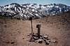
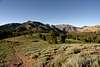
From the roadside take the Saint Marys Pass trail north. Though narrow, it is easy to follow when not covered in snow. Follow the trail up the hillside to Saint Marys Pass, gaining 1000ft over 1.3 miles. Once you reach the ridgeline there will be a large gravely field with many small boulders to your east(right). Turn away from the trail here, and head strait toward Sonora Peak, which is almost directly east of you. There is a lightly used trail heading up the gravely slope on the Northwest side of Sonora Peak. Follow that up the ridgeline to the summit. The summit is largely volcanic rock, and has several wind barriers setup for overnight stays. The summit registry can be located inside the top most circle. To return follow the Northwest summit back down and head strait for the ridgeline to the East. From the first saddle one can pick up the Saint Marys Pass trail back to the highway. The entire hike is about 5 miles roundtrip and 1700ft of elevation gain/loss.
 |  |  |
Essential Gear
Since Sonora Peak is located in the Northern Sierras, snow melts slower than many more sourthernly 11000ft peaks. November through late May snow will often cover much of the trail and summit. Though since there is no technical climbing, one can get by without crampons and ice axes. Late spring and late fall may require trekking poles and a solid pair of boots. If you plan on staying the night up top, bring water, since water is scarce on the hike in.
Miscellaneous Info
If you have information about this route that doesn't pertain to any of the other sections, please add it here.
Matthew Holliman - May 23, 2003 2:54 pm - Hasn't voted
Route CommentThere's a pretty sizable parking lot at the TH; roadside parking shouldn't normally be necessary.