
|
|
Route |
|---|---|
|
|
40.76360°N / 107.05757°W |
|
|
Hiking, Mountaineering, Scrambling, Skiing |
|
|
Summer |
|
|
Half a day |
|
|
Class 2 |
|
|
Overview
Meaden Peak East can be combined with Sand Mountain for a nice loop hike. From the summit of Sand Mountain, I followed the ridge straight over the top of Sand Mountain’s north summit and down to the Meaden Peak East/Sand Mountain saddle, but it’s probably easier to follow the Sand Mountain trail back down towards the trailhead until you can skirt around most of the extensive talus fields. Even with climbing both peaks, this is just a vigorous half day climb if you are in reasonable shape. Kim, Shaylee and Kessler approaching the summit of Sand Mountain on July 26 2008. Meaden Peak East is in the background.
Getting There
Without directions, this trailheads aren’t exactly easy to find, so I took lots of notes and have done my best to explain them. On our first attempt, we failed to find the correct trailhead, so these directions should help, even if they sound slightly confusing! The maps of the area are not accurate!!VIA STEAMBOAT SPRINGS
Option #1, East Loop:
From Steamboat Springs, drive to the north end of town and to where County Road 129 leaves Highway 40. A sign marks "Clark" and "Hahns Peak". This is the same road heading to the airport. Drive north on CR 129 for approximately 26 miles. Pass Steamboat Lake and turn left on County Road 62. Drive County Road 62 west and south for about 3.5 miles to FR 42 on the right. Turn right on FR 42 and drive for 0.6 miles to the forest service gate. This gate is locked until July 1st each year. Drive County Road 42 for 1.5 miles to where FR 480 (east loop) takes off to the left. The road here is bumpy, but still passable to 2wd’s if you go slowly. Turn left on to FR 480 which is a very rough 4wd road. Before driving this road, make sure you have a competent 4wd. We witnessed a grouse hunter damage his Dodge Durango on this road, so use caution. Follow the rough FR 480 for 3.3 miles to where the better road 480A turns left. Follow 480A for 0.5 miles to its end. This is the trailhead.
Another possible trailhead is road 480B (see the Routes Overview). From the junction of FR 480 and FR 480A as mentioned above, you can also turn right on 480 instead of left on 480A. If you do this, follow FR 480 for 0.8 miles to FR 480B. Turn left on FR 480B and follow this short road to its end.
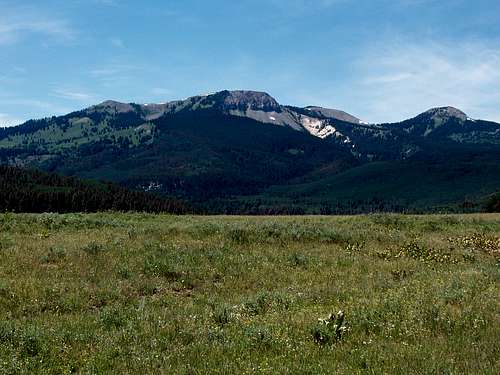 Sand Mountain (left) and Meaden Peak East (right) as viewed from the Southeast and on the road to the trailhead on July 26 2008.
Option #2, West Loop:
If you don’t have a 4wd, and if you want to minimize road walking, you may want to choose this option. From the Junction of County Road 42 and FR 480 (east loop), continue straight along County Road 42 and follow the bumpy road for another ~3.7 miles. The west loop of FR 480 takes off to the left. Park here if you have a 2wd, or follow FR 480 left for 0.4 miles to 480B (see above). To reach the trailhead at 480A, continue on FR 480 for another 0.8 miles to the junction of FR 480A. Turn right on 480A and follow it 0.5 miles to the trailhead.
VIA HAYDEN
From Walnut Street in Hayden, turn north on Walnut, a.k.a. County Road 76, and follow it north for 0.7 miles to County Road 80. Turn right on (gravel) County Road 80 and follow it for 27.3 miles to FR 42. Turn right on FR 42. The first 2.5 miles of FR 2.5 are pretty good, but it quickly turns into a 4wd road after that. The rough section last for 1.4 miles and ends at a saddle. Continue straight at the saddle (instead of heading left), and follow FR 42 for another 0.8 miles. At this point, FR 480-West Loop takes off to the right. See the above paragraph for directions to the trailhead from here.
Route Description
From the trailhead, follow the trail uphill and to the south. Almost immediately, there are several fallen trees to climb over or to walk around. There is a side track taking off to the right a short distance from the trailhead. Ignore it and stay left on the main trail. You will pass through some beautiful flower meadows before the trail begins switch-backing up the steep slope. The forest is thick, so the views are rather limited until you reach the ridge. Once the ridge is reached, you get an awesome view of the crumbling northeast face of Sand Mountain. You can also look down the east face to the “sandy” area that gives Sand Mountain its name. It appears to be some sort of ash or tuff and is rather colorful, and has some interesting rock formations. From here, the trail heads over to the southwest slopes of the mountain and more or less switch-backs up the slopes to the summit. Not far from the summit, there is a small helicopter serviced communications tower for the Forest Service, but the rest of the mountain is pristine.Enjoy the fine views from the summit. To the east are Hahns Peak, Steamboat Lake and the Mount Zirkel Wilderness Area. To the north is Meaden Peak. To the south is the Steamboat Springs area. To the west are the Elkhead Mountains, and you can view most of the major summits. To the north are Wyoming and the very interesting-looking Nipple Peak.
From the summit of Sand Mountain, retreat back down the trail until it zig-zags back into the forest and starts heading north again. The next objective is the prominent saddle between Sand Mountain and Meaden Peak East. I actually followed the north ridge of Sand Mountain and dropped off it to the saddle between Sand Mountain and Meaden Peak East, but because of extensive talus, it’s easier to contour around the mountain and back up to the saddle. There is only one fairly short talus slope to cross then and this is the recommended route.
 The red route is the recommended route to the saddle. Click for full sized photo.
From the saddle, Meaden Peak East is visible to the northwest and is a steep scramble to the top. Make sure to avoid the erosion prone slopes and stay as much as possible on the stable vegetation as much traffic (presently the peak sees almost no traffic) could cause erosion. (If climbing the peak in winter, this slope can be avalanche prone, so make sure to vary the route by staying in the trees more).
The views are wonderful and similar to those listed for Sand Mountain above.
From the summit of Meaden Peak East, descend back down to the San Mountain/Meaden Peak East saddle. From the saddle, head east and then northeast down the slopes. You should reach a creek (may be dry in late summer during drought years which you can follow down to the main Sand Mountain Trail. From where the creek crosses the trail, turn left and follow the trail back down to the trailhead.
This is a fine loop hike of about five miles.
 Sand Mountain as viewed from the saddle between Meaden Peak East and Sand Mountain on July 26 2008.