-
 4113 Hits
-
 74.01% Score
-
 4 Votes
|
|
Route |
|---|---|
|
|
46.78043°N / 11.49702°E |
|
|
Hiking, Mountaineering, Scrambling |
|
|
Summer, Fall |
|
|
Most of a day |
|
|
Exposed scramble |
|
|
Overview
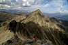
 Tagewaldhorn seen from Traminscharte Tagewaldhorn seen from Traminscharte |
From Penser Joch the approach to Tagewaldhorn takes about 3/4 of the time of the whole ascent. It is a constant up and down along solitary hiking trails and passes by quite a number of beautiful lakes which perfectly mirror the mountains around. The final ascent of the mountain runs along its northern ridge, an exposed knife edge of dubious quality. Still one of the main hiking trails of the area runs along this very ridge, probably one of the reasons why the underlying rock is very oished in places. Where it isn't it is covered by fine scree, very dangerous when descending from the summit.
Getting There
The hike starts at Penser Joch / Passo di Pennes. The main page describes how to get there.Route Description
 Descending the north ridge scree
- Start altitude: 2211m
- Summit altitude: 2708m
- Prevailing exposure: E
- Type: 4-5h one way
- Protection: None
The beginning of the route to Tagewaldhorn follows the route to Tatschspitze. You have to decide between a road hike to Penser Alm, about 500m south of Penser Joch Pass and a scramble to along the ridge which starts right behind the hotel at Penser Joch and leads southward (a bit above the road, but parallel to it). The two paths join each other on the north slopes of Astenberg / Monte Lastè.
The path (Sarntaler Höhenweg (or Hufeisentour)) leads around the hill-like summit on its south-western side of Astenberg and reaches a ridge, which connects it with Niedeck / Dosso Basso. To the north-east this ridge is very exposed and of questionable quality. This crappy rock will accompany you almost all the way. On the north-west slopes of Niedeck, the path climbs into a saddle, which again is quite exposed to one side (north).
From this saddle the Tatschspitze route leaves to the east while the Tagewaldhorn route heads down into a wide cirque which is filled with the first of the three lakes along the route, Seebergsee. From the lake it heads further down on the southern slopes of a steep creek valley before it climbs to a wide saddle. From here the route turns eastward and heads into the next cirque, crossing another creek. It passes another lake on its right and then gains the Distelsee Lake with great mirroring views to Sarner Weißhorn, Paulswand and Nebelseespitze.
Next a steep and winding path takes you up the next step in the terrain, right underneath the west face of Sulzspitze. From the top of the Col you can see the Tagewaldhorn north face for the first time in its full splendour. The path traverses east and soon heads up along scree slopes to Traminscharte / Giogo di Tramin a sharp col in the rocky north ridge between Tagewaldhorn and Sulzspitze. There are fine views from the pass towards the Zillertal Alps.
Zillertal Alps as seen from TraminscharteFrom Traminscharte the tricky part of the ascent starts. To the east the ridge drops off for several hundred meters while to the west there is a steep scree couloir. The first part of the remaining ascent follows the ridge, sometimes over rocks which hang over the steep drops to the east. There is a tower on the ridge which can be passed on its western side. The route follows the ridge until it gets to a real steep section. There you can decide between an exposed UIAA II/III climb along the ridge or you can pass over into the couloir to the west and scramble on up through the scree in its midst. After some 100m of elevation gain the couloir scramble rejoins the ridge which can be followed right to the top of the mountain. Several steps beneath the summit a trail joins from the southern side. The ridge turns westward and the last few steps towards the top are again relatively easy.
|