

-
 26356 Hits
-
 89.77% Score
-
 30 Votes
|
|
Mountain/Rock |
|---|---|
|
|
46.51388°N / 11.71644°E |
|
|
Hiking, Via Ferrata, Skiing |
|
|
Spring, Summer, Fall, Winter |
|
|
9704 ft / 2958 m |
|
|
Overview
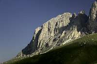
 Sasplat / Plattkofel / Sassopiatto seen from Passo de la Dona Sasplat / Plattkofel / Sassopiatto seen from Passo de la Dona |
Sasplat, better known by its German and Italian names Plattkofel and Sassopiatto respectively, is one of the most popular mountains of the Dolomites. It is one of the very few major mountains, which can be hiked and its elevation makes it a wonderful lookout peak. Access from Passo Sella / Sella Pass is short and along the route (Friederich-August Weg) several huts offer refreshments. Consequently, on a regular summer day huge crowds hike to the summit.
 |  |  |
Sasplat belongs to the circular Saslonch / Langkofel / Sassolungo Group and is located at its south-western end. It is the lowest of the mountains of this group and the only hiking summit as well. The normal route follows the huge slab to its south-west, which gave rise to the name of the mountain. Besides this crowded normal route there is a via ferrata from the inside of the Saslonch / Langkofel / Sassolungo Group, Oskar-Schuster-Steig, which climbs through the north-east face of the mountain. The ferrata is considered to be above average difficulty, maily because of long unprotected sections and the general brittleness of the route.
 |  |  |
Thanks to the closeness of the Saslonch / Langkofel / Sassolungo Group the top of Sasplat offers stunning views into its cirque more than 10000m below. The huge bulk of Saslonch rises on the opposite side and Pizes di Cin Dëic and Piza Grohmann can be seen on the eastern side. In the mid-range the Marmlada, Rosengarten and Geisler Groups can be seen and across Europe's largest pasture, Seiser Alm / Alpe di Suisi the mountains of the Ortler Group and Ötztal Alps can be made out in the distance.
Getting There
 On Top of Sasplat / Plattkofel / Sassopiatto
There are different villages below the Langkofel / Sassolungo Group: Ortisei / St. Ulrich, St. Christina and Selva di Gardena / Wolkenstein in Grödnertal / Val Gardena, Canazei and Campitello in Val di Fassa. Traveling to the Langkofel / Sassolungo Group most times means travelling to one of those villages. Grödnertal / Val Gardena and Val di Fassa are connected by Sellajoch / Passo Sella. The common approch to the Langkofel / Sassolungo Group is done from there. It can be accessed by car or by public transportation from both sides.
 |  |  |
Approach from S
- From the south (Lago di Garda, Trento, ...) take motorway A22.
- Leave it at Auer / Ora and follow SS48 through Val di Fassa to Campitello or Canazei.
Approach from N
- From the north (Germany, Austria, ...) take motorway A22 from Brenner / Brennero.
- Leave the motorway at Chiusa / Val Gardena and follow the road through Grödnertal / Val Gardena to St. Christina and Wolkenstein / Selva.
Approach from W
- From the west (Switzerland, Bodensee, ... ) take the road to Reschenpass / Passo Resia and travel SS38 through Vinschgau / Val Venosta to Meran / Merano and Bozen / Bolzano.
- Turn off onto SS241 east across Karerpass / Passo di Costalunga into Val di Fassa.
- At Vigo di Fassa take SS48 north to Canazei.
- Alternatively take the Brenner motorway A22 north from Bozen / Bolzano until you reach Klausen / Chiusa.
- Here turn off into Grödnertal / Val Gardena.
Approach from E
- From the east (Cortina d'Ampezzo, Sexten Dolomites, ... ) follow SS48 via Passo di Falzarego to Arabba.
- From Belluno (coming from Venezia or Friuli) you can reach Passo Pordoi using the Canale d'Agordo Valley until you reach Alleghe.
- A bit further north the road from Falzarego joins and leads you to Passo Pordoi.
- Cross the pass and turn onto SS242 to Sellajoch / Passo Sella.
Red Tape
 The Langkofel Cirque seen from Plattkofel
There is no red tape here. The parking lot at Sella Pass is restricted to those who visit the hut / restaurant there and parking along the road is not permitted. Starting early will give you the chance to park without fee.
Accommodation
 On Top of Sasplat / Plattkofel / Sassopiatto
Val di Fassa
Grödner Tal / Val Gardena
- www.valgardena.it
www.groeden.info
- St. Ulrich / Ortisei
- St. Christina / Santa Christina
- Wolkenstein / Selva di Val Gardena
You can find a number of campgrounds in Val di Fassa:
- Marmolada
via Pareda
Canazei
Tel.: +39 0462.601660
Fax: +39 0462.601722 - Catinaccio
via Avisio 15
Pozza di Fassa
Tel.: +39 0462.763305
Fax: +39 0462.763501 - Soal
via Dolomiti 32
Pera di Fassa
Tel.: +39 0462.764519
Fax: +39 0462.764609 - Vidor
Località Vidor
Pozza di Fassa
Tel.: +39 0462.763247
Fax: +39 0462.764780
Weather Conditions
Maps & Books
Books:There is one very recommendable book, Sella - Langkofel Extrem, which gives an overview over hundreds of climbing routes in the area. One third of the book deal with the Langkofel Group.
- Vie Ferrate
- Klettersteige Dolomiten
H. Höfler, P. Werner
Rother Verlag
ISBN: 3 7633 3096 8
- Hülslers Klettersteigführer
E.E.Hülsler
Bruckmann Verlag
ISBN: 3 7654 4161 9
- Klettersteige Dolomiten
- Hiking and Trecking
- Höhenwege in den Dolomiten
H. Dumler
Bruckmann Verlag
ISBN: 3 7654 3860 X
- Dolomiten
P. Fleischmann
Kompass Verlag
ISBN: 3 8705 1409 4
- Dolomiten 3
F. Hauleitner
Rother Verlag
ISBN: 3-7633-4060-2
- Dolomiten 4
F. Hauleitner
Rother Verlag
ISBN: 3-7633-4061-0
- Höhenwege in den Dolomiten
Maps:
I have been using the maps by Kompass Verlag. There are several which differ in scale:
- Val di Fassa, Marmolada, Gruppo di Sella
Kompass Map WK 686
ISBN: 3 8549 1768 6
Scale: 1:25000
- Sellagruppe / Gruppo di Sella
Kompass Map WK 59
ISBN: 3 8549 1066 5
Scale: 1:50000
- Val Gardena & Alpe di Siusi
Tabacco Map 05