
-
 2834 Hits
-
 74.01% Score
-
 4 Votes
|
|
Route |
|---|---|
|
|
47.35040°N / 10.91603°E |
|
|
Hiking, Scrambling |
|
|
Summer, Fall |
|
|
Most of a day |
|
|
Overview
 The route
| General: | 1000-2561m / 3281-8403ft, exposition S/SW, marked trails and unmarked scree fields/unsecured easy climbing |
| Effort: | About 1600m/5250ft 4-5h (600m/1969ft from Biberwierscharte 2-3h) |
| Power: | 3 - steep scree/UIAA I |
| Psyche: | 2 - Belaying not needed |
| Orientation: | 3 - unmarked above Biberwierscharte pass |
This is one of the standart routes up to both Marienbergspitze summits. This route is easier than the route via the south slopes, because up to the summit block it is not exposed and the rock difficulties are shorter. On the other hand this trail follows Schwärzkar and its scree fields and is quite exhausting. I recommend this route as the descent if you traverse Marienbergspitze.
Approach
Trailhead is the Biberwierscharte (2000m/6562ft). There are several possibilities to get there. If you traverse Marienbergspitze the best option is to start in Biberwier and follow trail #814 up to Biberwierscharte (about 2hours). Additionally you can reach this pass from Coburger hut within 30min via trail #814 leading to Biberwierscharte. | 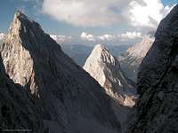 Great views of Sonnenspitze Great views of Sonnenspitze |
Route Description
 The gully.
Follow the unmarked trail starting at Biberwierscharte to the south up the gentle grass slope of Schwartkopf and Wamperter Schrofen into Schwärzkar. After about 30min you' ll get ontop of the grassy slopes and the trail continues on the scree field. This unmarked trail leads to Wamperter Schrofen, so you have to leave it somewhere. The best place to do so is when the trail turn sharply right to the east face of Wamperter Schrofen. Start to cross the scree field of Marienbergspitze to the left.
Between the two summits of Marienbergspitze are two gullies. It is possible to reach the south slopes of Marienbergspitze with both of them, but the left gully is the easier one. Cross the scree field towards this gully. You can use the small rocky ridge between the gullies to avoid the exhausting ascent within the scree field. But be careful, don' t climb to high there, because it gets difficult to reach the left gully the higher you get...
After you' ve entered the gully there is only one direction left: up! There are no seperations or other unexpected things. You can even see the exit of the gully. But be careful, because snow may lie there the hole year. After you' ve left the gully turn left (east) and find a way up the summit block and further up to the summit.
Essential gear
Hiking gear is sufficient. If you want to make sure nothing happens, bring a helmet with you. The climbing parts in the gully are mostly UIAA I so a rope and belaying isn' t required, if you' re familar with such terrain.
Well, Marienbergspitze is not a really difficult mountain, but it is not the place to find out if you can handle easy exposed climbing. So if you' re not sure about yourself or people with you, bring a rope.
Page history
| 19/Sep/2006 |
|