
-
 8750 Hits
-
 74.92% Score
-
 5 Votes
|
|
Route |
|---|---|
|
|
48.69100°N / 113.636°W |
|
|
Rock and Snow |
|
|
A long day |
|
|
4th or easy 5th class & 40-45 degree snow |
|
|
III |
|
|
Overview
 Base of the face
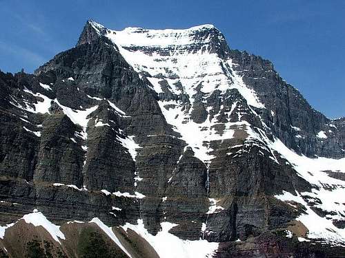
The east face of Going-to-the-Sun Mountain rises about 4,200 feet above Baring Creek at its base and about 3,200 feet from the base of the lower cliffs to the summit. The face can be roughly divided into four sections; the lower 1,000 foot cliff band, a 500 foot relatively low angle bowl, a 500 foot steeper rock section including the diorite sill and the algal reef (two formations extending through much of the Park and known for their steepness), and finally the 1,000 foot summit snowfield. A group led by Norman Clyde made the first recorded ascent of the east face of Going-to-the-Sun Mountain in 1924. The line taken by this group is not known. A CLIMBER'S GUIDE TO GLACIER NATIONAL PARK; J. Gordon Edwards includes two routes on the east side of the mountain, the Sexton Glacier Route and the Southeast Ridge Route. Both of these routes bypass the imposing 1,000 foot lower cliff band to access the upper part of the east face and finish to the top via the final snowfield. A much more interesting and challenging route is to climb the lower cliff band directly.
Approach
Park at the Siyeh Pass Trailhead near Baring Falls (Map). Hike up the trail along Baring Creek until a good crossing spot with open slopes to the base of the face is found. Cross the creek and ascend to the base of the face.
Route Description
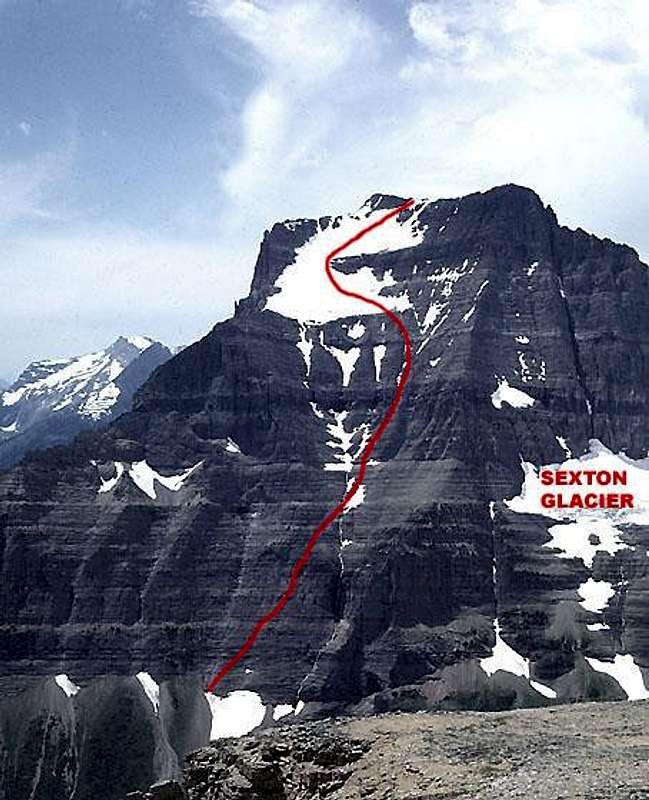
Probably the easiest way up the lower cliff band is described in a letter from John Alke published in part in GMS Newsletter Number 4, Summer 1982. He describes an ascent of the face by he and his brother, Van, in July of 1978. "....the concave upper face is drained by a stream which drops over the lower face in a high waterfall. To the south, in the upper half of the lower face, a chimney / dihedral marks the major weakness in the lower face. To the south of that, a very faint cascade comes down another weakness to the scree slopes. We climbed next to the faint waterfall to about mid height on the lower face, traversed north along a very obvious traverse ledge to the chimney / dihedral, which we followed to the top of the lower face. We then crossed the stream above the waterfall and proceeded more or less straight up to the top. There was a little moderate fifth class climbing in the lower part of the chimney / dihedral and in the upper part of the waterfall." Paul Bishop and I followed essentially this route on our ascent in 1990. Rather than climb directly up next to the faint waterfall and then traverse, we angled across the face from its base into the weakness described as a chimney / dihedral, which I would call a very shallow chimney. We did not think that any of the climbing was YDS 5th class, but it is at least very exposed 4th class climbing. Once above the lower cliff band, there are numerous options for ascending the upper part of the face to the summit snowfield. The bowl can be ascended easily almost anywhere. Above the bowl, there are three prominent streams draining the summit snowfield each with a corresponding chimney through the diorite sill. These are running water most of the season. To the climber's right of these three chimneys there is a fourth shallow chimney or break in the diorite sill which runs little or no water and is probably the best way through. This extends upward through the algal reef. Once above that, one can traverse easily to the base of the snowfield. Once above the diorite sill, it is also possible to traverse south and climb any of the ribs between the streams. The summit snowfield averages 40 to 45 degrees. Conditions vary from year to year and with the time of year. Early in the season, the snow may extend all the way to the summit, but most of the time it extends to the crest just north of the summit. Ice is possible late in the season.
On the Face
 The central basin
 |  View down
 |  Base of snowfield
 |  On snowfield
 |
Essential Gear
Rope, ice axe, and crampons. A light rack may be wanted by some parties.
 This photo shows the shallow chimney through the lower cliff band - traces of snow angling to the right (first snow left of waterfall)Photo by montanaboy.