
|
|
Route |
|---|---|
|
|
40.77380°N / 110.7521°W |
|
|
Long ridge walk |
|
|
A few days |
|
|
Class 2 |
|
|
Approach
Note: Things have changed since I have been to this trailhead.
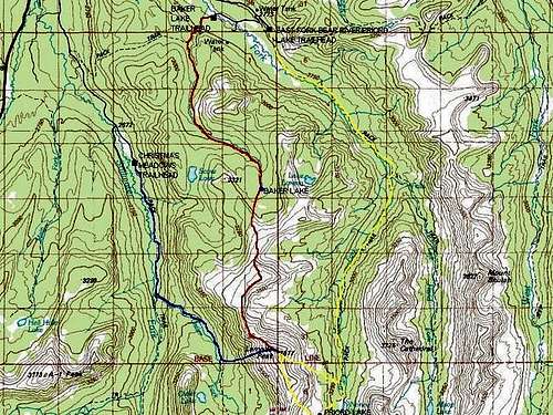
First you must drive Highway 150 south from Evanston Wyoming, or east and then north from Kamas Utah. The North Slope (gravel) road heads east from Highway 150 either just south of the Bear River Lodge, or two miles north of the Bear River Visitor Center. After following the North Slope Road for two miles, turn right and follow the main road all the way, but turn right at the major junction and into the Hinkley Scout Ranch. Follow the road past the first camp and to the second. Park or walk to just out side the camp and near the river bridge, especially when the camp is operating Monday though Saturday. The trail is a public access trail (I verified this with the forest service), but don’t park right in the scout camp.
Route Description
This is the easiest of the three routes described (or at least used to be!), but also the least used. It is a very scenic route as well since it follows a ridge well above timberline for much of the route. Solitude is assured. Note: The trail to Baker Lake has deteriorated since I have last been on it so the route is more difficult than it used to be.
See this video for updates though they descend from Baker Lake.
2021 Updates on the Route to Baker Lake
From Camp Evergreen at 8800 feet elevation, locate the Baker Lake Trail. The signpost is long gone so you will have to look for the trail, or what's left of it. Follow the trail as it switchbacks up the slope. There is a junction after a short distance, but as of the mid 1990’s, it was hard to find and not signposted. The Bear River-Smiths Fork Trail branches to the right, but a tree is blocking the trail and without a signpost, you may miss the junction. (Note: The trail junction is shown incorrectly on the 7.5 minute map Christmas Meadows and is lower than indicated). Luckily the main trail is easy to find (or used to be!!), but if you do see a junction, head left.
The Baker Lake Trail continues to switchback to a meadow and levels off. From here, the trail continues to follow Boundary Creek at a gentle grade before reaching a meadow and some beaver ponds. This is about 3.75 miles from the trailhead. The trail fades here, and it is a waist of time to look for it. Simply follow Boundary Creek for another 1.25 miles to Baker Lake. Baker Lake makes a nice little used campsite for a base camp. The lake is at 10,420 feet elevation and 4.5 miles from the trailhead.
From the lake, route-find to the south via any convenient route. There are several routes to choose from. Once above timberline and on the ridge, follow the ridge south all the way to the summit of Lamotte Peak. This is a very pleasant and scenic walk with great views. This route is fairly easy with no loose rock or boulders present on every other route to Lamotte Peak. Instead there are grassy and slightly rocky slopes. The distance from Baker Lake to the summit of Lamotte Peak is about 4 miles, making the total distance from the trailhead 9.5 miles with about 4000 feet elevation gain.
There is an alternate return route. Instead of dropping back down to Baker Lake, drop down to Lake Lorena (to the east) instead. Lake Lorena is a very secluded lake and very seldom visited. From there the route follows the stream down to the East Fork Bear River (which must be crossed). There is no trail at all and you must skirt around a rather high waterfall. The lower end of the route is the most challenging through thick forest.
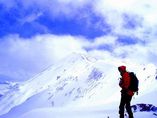 North Ridge of Lamotte Peak
Essential Gear
A good pair of boots is needed.
SabineInUtah - Aug 16, 2021 12:08 pm - Hasn't voted
Access to trailhead no longer as describedI tried to find this trailhead and it is no longer marked. Also, it is in the middle of the Hinckley Boy Scout Ranch and you have to trespass to access it. The Boy Scout Ranch is gated and you have to walk on their property to find the trail. There is no sign for the trail and no trail. I only found what was most likely Boundary Creek, which was dry in August 2021. Hiking along the Creek bed would be difficult due to deadfall and undergrowth. The sites mentioned in the route description no longer exist, such as Camp Frontier and Evergreen. It seems the Boy Scout Ranch is permanently closed as I would guess otherwise, it would be have been open in mid-August. There was no sign it had been open this year. I only knew I was in the correct drainage at Boundary Creek, because I checked google maps when I returned home. High Uintas Trails Illustrated map is useless in finding the access.
Scott - Aug 16, 2021 1:18 pm - Hasn't voted
Re: Access to trailhead no longer as describedGood to know. The land is leased by the LDS Church, but they have recently decided to sever ties with the Boy Scouts so I don't know what's going to happen to all the LDS-run scout camps. I used to work for Camp Evergreen and at least back then the Forest Service Lease said that they were supposed to keep access open to the trails even of people park outside the camp and walked through. I'll call the FS and see what's going on with access.
Scott - Oct 22, 2021 6:53 pm - Hasn't voted
Re: Access to trailhead no longer as describedI talked to the FS and the trail is still open, but you have to park at the gate. Here is a 2021 video of the trail, but they only descend it. https://www.youtube.com/watch?v=KPqzl5xiUzw It's too bad access has gotten worse in recent years!