
|
|
Route |
|---|---|
|
|
39.63630°N / 105.794°W |
|
|
Steep snow |
|
|
Half a day |
|
|
class 2+ |
|
|
Overview
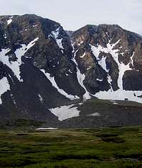 Goatfinger is the center snow couloir.
The Goatfinger route is so named (one can only assume) for the finger-shaped couloir and the likelihood of encountering mountain goats. Either can make your trip more interesting. Together, they can make it very dangerous! All in all, this is a great snow climb in season.
Vital Statistics:
From the trailhead, this round trip should be about 7 miles, with 2620' elevation gain. Maximum snow angle in the couloir is 55º. Rated class 2+.
Approach
 Approaching from the north
Begin at the Stevens Gulch Trailhead. An early start is recommended to beat the crowds going up Grays and Torreys. Follow the Grays Peak Trail about 1.3 miles, until you approach the large sign. About 100 yards short of the sign, look sharp for an old road bed that shoots off to the left, perpendicular to the trail. The road immediately crosses a creek and leads south and west toward Mount Edwards' and Grays' north slopes. Follow the road if you can, or cross the basin directly. Position yourself under the large, 1000 foot couloir that leads directly to the 13,540-foot saddle. Pull out your ice ax and helmet now.
Route Description
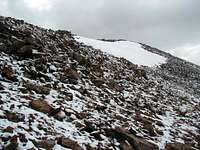
 Edwards' north face
The north facing couloir holds good snow most of the way up, at least thru June. However, the top 300 feet of the couloir was almost snow-free in late June 2004. As you climb the couloir, stay out of the center as much as possible to avoid falling rocks. With climbers or mountain goats above you, the danger is magnified. Gerry Roach relates a humorous story in his Colorado's Thirteeners, of a mountain goat knocking rocks down on him from the top of this couloir. Despite their handsome appearance, mountain goats can be rather obnoxious creatures and cause you a lot of trouble.
 Looking down from the saddle
Follow the couloir to the saddle at 13,540'. As you near the saddle, the couloir broadens but does not become any less steep. The saddle divides two false summits on Mount Edwards' west ridge. From there, contour around to the east, around the false summit. Any elevation you gain here, you will have to give back. After you reach the next saddle, follow the ridge to the summit. A climbers trail makes it easy going.
 West ridge to summit
Essential Gear
Ice ax and helmet are essential life saving devices here.Crampons are also recommended, and are mandatory in icy conditions, as I learned first hand. A fall in the couloir can send you a long ways down in a very short time. On my descent I was nearing the bottom of the steep couloir and removed my crampons to save them from wear on the rocks. A few steps later my feet flew out from under me and instantly I was careening down an icy slide. My first attempt at self arrest failed as the ax wouldn't bite. Accelerating out of control, I slammed the ax down again, in a sheer panic this time. I skidded to a stop just short of a rock outcrop. Life saved. This was my first time to wear crampons, and I learned to keep them on until all the steep terrain is behind me.