
-
 12286 Hits
-
 72.08% Score
-
 2 Votes
|
|
Route |
|---|---|
|
|
40.67080°N / 111.683°W |
|
|
Hike |
|
|
Half a day |
|
|
Class 2 |
|
|
Overview
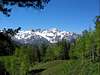
The Mill B North Fork trail is one of the longer approaches to Gobblers Knob, and involves the most elevation gain of the popular routes to the summit. Nevertheless, this is very scenic and enjoyable approach to the summit. It is also less freqently used than the more popular approaches, therefore offers a better opportunity for solitude.
For the more energetic hikers in the crowd, this route also offers an optional ascent of Mount Raymond, the next major peak to the west of Gobblers Knob.
 |  |  |
Getting There
This route begins at the Mill B North Fork trailhead in Big Cottonwood Canyon. Refer to the main page 'Getting There' section for directions to the trailhead.
Stats
One-Way Hiking Distance: 5.4 miles
Elevation Gain: 4,046 ft.
Average Gain per Mile: 750 ft.
Trailhead Elevation: 6,200 ft.
Summit Elevation: 10,246 ft.
Route Description
From the trailhead on the north side of the highway, ascend the stairs heading east as the trail parallels the highway for a few hundred feet, then makes a couple of switchbacks before joining the North Fork creek bed for a short distance.
After a sharp turn to the right (east) the trail makes a series of switchbacks as it begins climbing a steep forested slope. Above the switchbacks the trail continues east for a period, offering excellent views into the Lake Blanche and Broads Fork drainages across the canyon to the south.
Continue along the trail as it turns northward and continues generally north for approximately one mile (with an occasional switchback along the way), climbing steadily along the way.
The trail turns eastward for a brief period, before finally arriving at a T-junction with the east-west Desolation Trail. Turn right (east) at the T-junction.
The next mile or so offers some of the most enjoyable hiking of the route, as the trail levels off and heads first east along the base of Mount Raymond's southeast summit ridge, then curves back to the west for a brief period as it heads into Mill A Basin, remaining essentially level all the way.
From Mill A Basin the summit of Gobblers Knob will make its first appearance. Follow the trail as it heads north-east towards Baker Pass, the low saddle between Gobblers Knob and Mount Raymond.
From Baker Pass it's once again time to gain altitude, as the faint trail begins climbing the final 800 vertical feet up the west ridge towards the summit. The ridge reaches the top of a false summit (elevation 10,224), but the true summit is an easy 1/4-mile walk to the east.
Extra Credit: Mount Raymond Ascent
Time and energy permitting, it would be a shame to pass up the opportunity for a bonus summit by climbing Mount Raymond on this same hike. This is best done from Baker Pass on the descent from Gobblers Knob.
From Baker Pass it is a simple matter to ascend the north-east ridge of Mount Raymond. This is an easy scramble of 0.6 miles and roughly 800 vertical feet of elevation. From the summit of Mount Raymond the quickest option for descent is to proceed down the ridge to the west several hundred feet, then turn left down the steep south-facing slopes. Continue descending until the east-west Desolation Trail is intersected, as described in the above route description.