
|
|
Route |
|---|---|
|
|
39.61700°N / 106.142°W |
|
|
Ski Descent, Snow Climb |
|
|
Half a day |
|
|
Steep Snow to 50 degrees |
|
|
Silver Couloir General Information
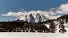
The Silver Couloir, also locally referred to as the North Chute, can easily be seen from the highway North of Silverthorne and has most certainly caught the eye of many climbers and skiers. It is a steep and direct route with an overall angle of about 40 degrees as it climbs over 2100 ft to within a few hundred feet of the summit.The Couloir is very prone to avalanche activity and should only be entered during the spring after conditions have stabilized. Even then climbers/skiers should check with the Colorado Avalanche Center, local climbing shops and be prepared to access the conditions for themselves once they arrive.
This route is usually seen as more of a ski descent rather than a climbing route. I have never heard of anyone climbing the route, although it undoubtedly has been climbed. For those who enjoy backcountry sking, this route holds snow well into the warmer months and provides a great run on corn snow with a short relatively short approach. With the right conditions one can ski from the true summit, deep into South Willow Creek. I'd recommend stopping as the chute enters treeline at the irragation ditch to make the return to your car easier.
 |
Approach
Follow the directions on the main page to the Ryan Gulch TH. Follow the described trail to the fourway junction with the Mesa Cortina Trail. Instead of turning left to Buffalo Cabin, continue straight on the South Willow Creek trail.Follow the trail to the first clearing which is followed by a relatively steep descent. Keep descending until the trail hits an old irragation ditch and turns left to follow the ditch. Continue along the trail until you come to a very well defined avalanche path crossing the trail. It is in this vicinity that the standard summer trail leaves the ditch and descends into the South Willow Creek drainage. Instead for this climb, continue along the ditch in to a small patch of trees and out into another small avalanche path. Continue on into the trees again and keep going until you exit out into a large opening. Looking up to the left you begin to see the Silver Couloir, which in reality is more Northeast. From here it is a pick your path to the beginning of the climb.
Route Description
The real couloir begins around 10,300 ft and climbs for over 2100 ft until it flatens near the summit. The route is very easy to follow up a relatively wide coulior. The steeper, 48 degree, sections are about 1/3 of the way up the climb.At around 11,700 ft the coulior splits into a Y, either side leads to the summit and your choice will depend on current conditions. The angle finally starts to ease up near the top and finally reaches the end at around 12,450 ft, at which point it is a pleasent 1/4 mile to the summit.
For those with strong backcountry sking skills, I would recommend sking the Silver Couloir as a descent. For all others you might consider returning via the normal hiking route on the East Slopes.
 |
Essential Gear
Crampons and Ice Axe highly recommended.Due to the angle of the climb, avalanche gear including beacons and shovels is also recommended.
Don't forget the skills necessary to use them.
For experienced backcountry skiers, skis for the descent are a must. Only attempt this if it's within your ability and comfort range.