
-
 87177 Hits
-
 90.42% Score
-
 32 Votes
|
|
Mountain/Rock |
|---|---|
|
|
39.61700°N / 106.142°W |
|
|
12777 ft / 3894 m |
|
|
Gore Range Overview
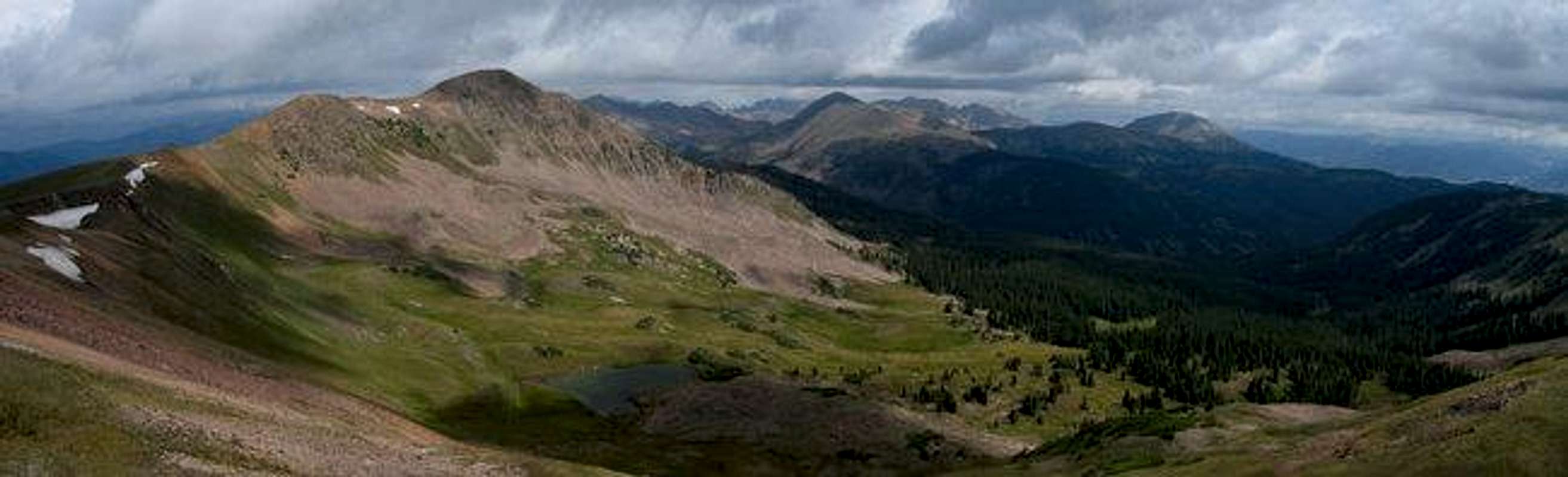
 Colorado’s spectacular but barely known Gore Range is host to many alpine summits over 13,000-ft and many more summits over 12,000-ft. In the relatively short stretch from Gore Pass in the north to Tenmile Creek in the south, the Gore range is densely populated with 50 some mountains over 12,000-ft. The Gores, rather then consisting of large isolated mountains rising from the timber or tundra, consist instead of dramatic serrated ridges, with the summits being ridge junctions or highpoints. These dramatic ridges are riddled with gnarled, tooth-like spires that have mesmerized many world-class climbers. Many of these high and wild ridges actually have names like, The Zodiac Spires, Ripsaw Ridge, and The Grand Traverse.
Geologicaly the Gore Range is a fault-block mountain range. Similiar to the Sangre de Cristos of Colorado and the Tetons of Wyoming in that these ranges are bounded by faults that broke and shifted, thrusting up the mountains while downdropping the valleys. Although the rock is similiar to the Idaho Springs Formation of the Front Range, the rugged Gore's contrasting orogensis makes these mountains look quite different from the glaciated folded anticline that makes up the Front Range. Glaciers played an extensive role in carving the cirques and spires that abound in the Gores. Many of the drainages are choked by large terminal morraines at their lower reaches and cut by successive headwalls higher up. Many headwalls are graced with gorgeous waterfalls.
The Gore Range is almost completely encompassed by the Eagles Nest Wilderness. This 133,325 acre Wilderness Area was established in 1976. It is popular (especialy the Vail side) but wilderness protection has granted a lasting pristene quality that is palpable. Despite the network of access trails, many drainages (the upper reaches in particular) remain trail-less. Wilderness regulations do apply; please follow them as this area is a real treasure.
Only 60 miles at its closest point from Denver, the Gore Range as a whole is relatively unknown. Due to the lack of mining roads that criss-cross more popular mountain ranges the interior of the Gore Range can be difficult to reach. Of the summits of the Gore Range none attain the magic 14,000-ft mark, which accounts for some of the ranges obscurity. The monarch of the Gore Range is the 13,534-ft. Mount Powell at the north end of the range. Overall, the west side of the Gore Range is more accessible than the east. If approaching from the east, expect long, tedious, bushwhacking adventures with difficult route finding.
A result of the Gore Range's obscurity is that few of the summits are officialy named. The Colorado Mountain Club and enterprising climbers have often bestowed their own names. These unofficial designations often are the "alphabet" designations of the early CMC trips (relics of the 1930's) or the more inspired names that came latter on (The Spider, Mount Solitude, etc). A list of these names and their elevations can be found at Gerry and Jennifer Roach's wonderful website. The process educating one's self about these mountains is quite rewarding. Hand label your maps.
Those of us that are determined to spend some time climbing the Gores should own updated U.S. Geological survey topography maps and brush up on their compass skills. Precise planning and execution are of paramount importance when selecting routes in this range. With solid route finding, many of these quiet summits can be climbed without a rope. Major faces and long jagged ridges provide unlimited technical climbing opportunities as well. An ice axe is highly recommended on any early season climbs.
Please do your own research and homework for the Gores because this mountain range lacks any current guidebook exposure. After developing strong map reading skills, go and discover for yourself the Gore Range magic you occasionally hear about.
Please see Theron Welch's excellent page on the Gore Range for more information. His photos and descriptions are inspiring and informative. Thank you Mr. Welch.
Text graciously provided by Kane with some elaboration by myself.
Buffalo Mountain Overview

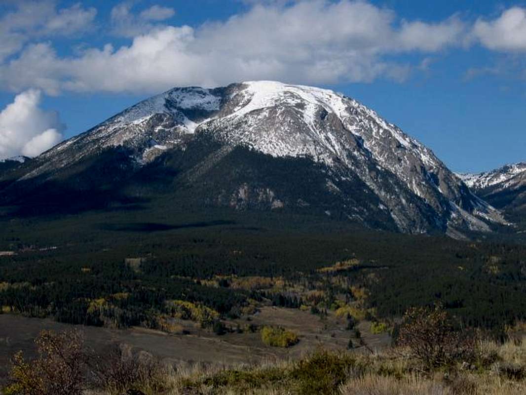
Buffalo Mountain is the massive sleeping guardian on the south east edge of the Gore Mountains. It is situated to guard the wild environs to the north from the eyes of civilization, yet Buffalo's slopes are spied by millions along the I-70 corridor. Indeed it is the first Gore Range summit visable when descending I-70 west from the Eisenhower Tunnel. For this reason Buffalo may be the most well known Gore Range summit. Buffalo Mountain rises spectacularly above the communities of Silverthorne, Dillon, and Frisco. In the winter time this mountain is graced with two very prominent avalache paths that are visable for many miles.
Buffalo Mountain may resemble a sleeping version of its namesake but it does have some serious aspects.The north face rises dramaticaly above Willow Creek and this side may indeed have Buffalo's horns. The main summit region is a rolling talus tossed tundra. Just to the south of the true highpoint the ridge narrows and becomes a very short, sporty scramble to the southern sub-summit Sacred Buffalo. This high ridge is unexpected and well worth investigating, being suspended like a draw bridge between two gentle summits.
Buffalo Mountain has recently been installed with a very pleasant trail constructed in July of 2004. This well designed path allows for an easy ascent of what would otherwise be a tedious talus field. This 3.6 mile long trail offers a great vantage to preview the more rugged Gores further north.
While the vantage of the Gores and nearby Tenmile Mountains is undeniably grand one unique aspect of being on Buffalo Mountain is looking down on the tiny little sail boats on Lake Dillon. This visual dichotomy of surf and turf makes for some interesting eye candy.
The dramatic quarter mile wide, two-thirds of a mile long, avalanche scar on the north eastern face of Buffalo Mountain is the result of a 1986 Avalanche. On febuary 22, after a week of 5 feet of fresh snowfall a slab avalache gave way near the summit and rushed down the mountainside leveling 200 year old trees and generating 100 mile an hour winds down valley.
Maps and Directions
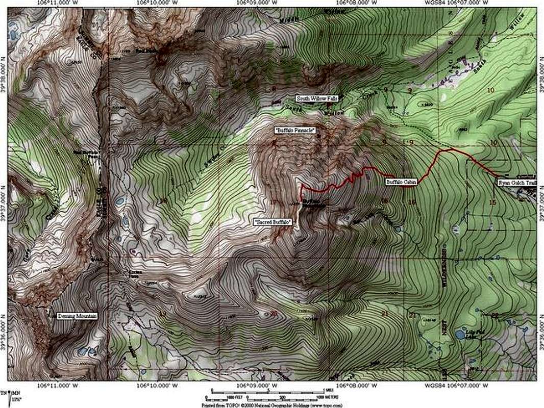
Ryan Gulch Trailhead:
The Ryan Gulch Trailhead is the primary acess point on Buffalo Mountain. To get the take the Silverthorne exit off of I-70. Go north on Highway 9 to the first light and take a left. This becomes the Ryan Gulch Road. Follow this about 3.5 miles as it switchbacks up the slopespast condos and mountain homes. The parking for the trailhead is on the southside of the road. The Ryan Gulch Trail is found to the right (east) of the parking lot. This is not to be confused with the Lilly Pad Lake Trail which is found to the left on the west side of the parking area.
Routes on Buffalo Mountain
- Buffalo Mountain Trail: 4 miles roundtrip, 3,200 ft. elevation gain, class 1
The Buffalo Mountain Trail begins at the Ryan Gulch Trailhead above the Wildernest housing development at the foot of Buffalo Mountain. From the trailhead travel east passing the wilderness boundary after a quarter mile. Follow the trail to the fourway junction that offers access to the Mesa Cortina Trailhead and the Gore Range Trail. For the Buffalo Mountain Trail turn left and follow the branch that leads to Buffalo Cabin. after a half mile the unimpressive remains of Buffalo Cabin are encountered. From just to the left of the cabin the new Buffalo Mountain Trail begins switchbacking up the steep slope above . From timberline the excellently designed and executed winds its way up a steep talus slope turning what would be a bit of a slog into a pleasant stroll. The slope soon relents the trail passes through some high krummholze. This maks the begining of the gentler summit slopes. Follow the cairns to the short shelter wall that marks the summit. A nice view of Red Peak and East Thorn dominates the scenery north. Unfortunately Red Peak's mass blocks most of the more scenic Gore summits to the north. For more scenery continue on to Sacred Buffalo. - Sacred Buffalo from Buffalo Mountain Summit: 1/2 mile roundtrip, marginal elevation gain, class 3
Sacred Buffalo is the southern subsummit of Buffalo Mountain. It is connected by a suprisingly narrow ridge which hovers between the summits. On the east the ridge drops steeply into the upper Salt Lick Cirque and on the west equaly impressive drops make the terrain suddenly interesting. The crux is a scruffy downclimb near Sacred Buffalo's again benign slopes. The mini-traverse is definately worth while and may remind Gore Range veterens of the more archtypal Gore summits to the north.
![]()
![]()
![]()
![]()
![]()
Red Tape
“Red Tape” per attm
No permits or fees are required. Like all wilderness areas no mechanized or motorized vehicles are permitted within the Eagles Nest boundaries.
Wilderness is land set aside as part of wild America, where man can be a visitor. The natural environment has not been disturbed. Travel is restricted to foot or horseback. No mechanized equipment is allowed.
For more information, contact the U.S. Forest Service at the # below:
Additional Resources:
Eastern Portion of the Wilderness:
Dillon Ranger District
680 River Parkway
Silverthorne, CO 80498
970-468-5400
or
Western Portion of the Wilderness:
Holy Cross Ranger District
P.O. Box 190, 24747 US HWY 24
Minturn, CO, 81645, Phone: 970-827-5715![Buffalo Mountain photo_id=107906]()
The Gore Range from the south in March. Buffalo Mountain is the summit with the twin avalanche paths.
When To Climb
While the close proximity to a plowed-paved trailhead might make this a yearround summit the upper slopes are likely avalanche prone. The two huge slide paths that run off the mountain should be respected. Summer and Fall this is a nice short hike.
Camping
Available near the "Buffalo Cabin". However this is such a short enterprise from the east that camping isn't much of an advantage. Those looking for an overnighter would be better off ascending Buffalo Mountain from the South Willow Creek Drainage. From high in that basin it would be possible to tackle the trailless west ridge of Buffalo.
Mountain Conditions
Expect snow in the Gore Range until early June. - Colorado Avalanche Information Center (CAIC)
- Vail Web Cam
Click image to enlarge
Click here to view a 7-day forecast for The Gore Range
-
Text graciously provided by Kane


heatherdene - Sep 18, 2010 8:26 pm - Hasn't voted
Buffalo Mtn, Co - DistanceWe recently did buffalo mtn in colorado and the trail is 6.2Mile roundtrip and not the 4 shown on the website. i used a gps. Also the talus filed is a class 2 not a class 1 as mentioned in the text. Regards howard (heatherdene)
Rolex45 - Sep 30, 2017 1:26 pm - Hasn't voted
Buffalo MountainClimbed Buffalo Mt with my son, Travis, on 28 Sep 17. Wx was marginal with lite snow cover. I would agree with the longer distance. Unfortunately, my GPS kept breaking lock with the satellites so I cannot give you a GPS distance. For sure, 4 miles is wrong and short. Talus climb begins as you exit the trees. There is a large cairn to mark actual trail. Unfortunately -- in limited vis -- we saw a small cairn above and to the left of the large cairn and headed up. The real trail is to the right of the large cairn. Our route was steep and difficult and marked by cairns. The actual trail is much better and carefully marked by cairns...we came down on the actual trail. I agree with Class 2 for the talus/scree with 2.5 in some areas. With lite snow cover, I was testing hand holds and scrambling. CDH