
|
|
Route |
|---|---|
|
|
40.73130°N / 110.8919°W |
|
|
Hike, cross-country route to the summits |
|
|
Half a day |
|
|
Class 2 |
|
|
Driving to the Trailhead
To reach the Lofty/Pass Lake Trailhead, drive Highway 150 32 miles north, and east of Kamas or 46 miles south of Evanston. There is a sign that marks the trailhead (west side of the Highway).

Route Description
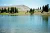
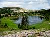
For convenience, the trail will be described in a clockwise direction. From the trailhead (at 10,100 feet elevation), find the trail heading west. There is a sign pointing the way to Lofty Lake. After heading west a short distance, there is a junction. The trail to the left (east) heads back to Highway 150 just accross from Pass Lake, so turn right. Continue west from the junction and reach another junction after just a short distance. There is a sign at the junction. Turn right and take the Lofty Lake Trail. After another .5 miles, Reids Meadow (just below 10,000 feet elevation) is reached. There is a spectacular view of Reids Peak and Bald Mountain from this meadow. From Reids Meadow, the trail climbs uphill to the north. There are a few steep sections before the trail climbs to Kamas Lake (10,400 feet elevation). Kamas Lake is very beautiful with spectacular ridges rising from the lake. From Kamas Lake, the trail heads north to "Cutthroat Pass" (10,700 feet elevation). There are good views from here of Cutthroat Lake located below and north of the pass. There are also good views of the High Uintas Wilderness to the northeast. The trail continues heading east up a ridge from the pass and then turns south to reach Lofty Lake. Lofty Lake is a scenic mountain-top alpine lake sitting at timberline and at 10,810 feet elevation. Both Scout and Lofty Peaks are short boulder-hops from the lake. Both climbs are very worthwhile. There are excellent views of the surrounding lakes, basins, and the High Uintas Wilderness from the summits. From the Lofty Lake, you can either head NE to the summit of Lofty Peak or south to the summit of Scout Peak. There is no trail, but the routes are obvious and easy. Since the lake is near the summit of the mountain, both peaks are only about 300 feet above the lake. After summiting the peaks, you can either return to Lofty Lake, or head directly to the gentle saddle between the two summits (10,900 feet elevation). You will re-join the Lofty Lake Trail here. From the saddle, the trail drops south to Scout Lake (10,400 feet elevation). There is a junction here with a trail that heads east to Steiner Boy Scout Camp; do not head left and into the scout camp. The trail also crosses a road in this area. Do not follow the road, but cross the road and find the trail on the other side. Many people get confused here. Picturesque Lake is reached shortly after. From Picturesque Lake, the trail heads down to the souuthwest and reaches the trailhead where you started. To hike the loop and climb both peaks, the round-trip distance is about 4.6 miles.


 |
Essential Gear
A good pair of boots is needed.