|
|
Route |
|---|---|
|
|
40.75480°N / 107.047°W |
|
|
HIke |
|
|
Half a day |
|
|
Class 1 |
|
|
Approach
VIA STEAMBOAT SPRINGSOption #1, East Loop:
From Steamboat Springs, drive to the north end of town and to where County Road 129 leaves Highway 40. A sign marks "Clark" and "Hahns Peak". This is the same road heading to the airport. Drive north on CR 129 for approximately 26 miles. Pass Steamboat Lake and turn left on County Road 62. Drive County Road 62 west and south for about 3.5 miles to FR 42 on the right. Turn right on FR 42 and drive for 0.6 miles to the forest service gate. This gate is locked until July 1st each year. Drive County Road 42 for 1.5 miles to where FR 480 (east loop) takes off to the left. The road here is bumpy, but still passable to 2wd’s if you go slowly. Turn left on to FR 480 which is a very rough 4wd road. Before driving this road, make sure you have a competent 4wd. We witnessed a grouse hunter damage his Dodge Durango on this road, so use caution. Follow the rough FR 480 for 3.3 miles to where the better road 480A turns left. Follow 480A for 0.5 miles to its end. This is the trailhead.
Option #2, West Loop:
If you don’t have a 4wd, and if you want to minimize road walking, you may want to choose this option. From the Junction of County Road 42 and FR 480 (east loop), continue straight along County Road 42 and follow the bumpy road for another ~3.7 miles. The west loop of FR 480 takes off to the left. Park here if you have a 2wd, or follow FR 480 left for 0.4 miles to 480B. To reach the trailhead at 480A, continue on FR 480 for another 0.8 miles to the junction of FR 480A. Turn right on 480A and follow it 0.5 miles to the trailhead.
VIA HAYDEN
From Walnut Street in Hayden, turn north on Walnut, a.k.a. County Road 76, and follow it north for 0.7 miles to County Road 80. Turn right on (gravel) County Road 80 and follow it for 27.3 miles to FR 42. Turn right on FR 42. The first 2.5 miles of FR 2.5 are pretty good, but it quickly turns into a 4wd road after that. The rough section last for 1.4 miles and ends at a saddle. Continue straight at the saddle (instead of heading left), and follow FR 42 for another 0.8 miles. At this point, FR 480-West Loop takes off to the right. See the above paragraph for directions to the trailhead from here.
Route Description
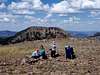
From the trailhead, follow the trail uphill and to the south. Almost immediately, there are several fallen trees to climb over or to walk around. There is a side track taking off to the right a short distance from the trailhead. Ignore it and stay left on the main trail. You will pass through some beautiful flower meadows before the trail begins switch-backing up the steep slope. The forest is thick, so the views are rather limited until you reach the ridge. Once the ridge is reached, you get an awesome view of the crumbling northeast face of Sand Mountain. You can also look down the east face to the “sandy” area that gives Sand Mountain its name. It appears to be some sort of ash or tuff and is rather colorful, and has some interesting rock formations. From here, the trail heads over to the southwest slopes of the mountain and more or less switch-backs up the slopes to the summit. Not far from the summit, there is a small helicopter serviced communications tower for the Forest Service, but the rest of the mountain is pristine.Enjoy the fine views from the summit. To the east are Hahns Peak, Steamboat Lake and the Mount Zirkel Wilderness Area. To the north is Meaden Peak. To the south is the Steamboat Springs area. To the west are the Elkhead Mountains, and you can view most of the major summits. To the north is Wyoming and the very interesting-looking Nipple Peak.
The round trip distance from the end of the 4wd road is about 3 miles with about 1500 feet elevation gain. If you don't have a 4wd, the hike is much longer.