
-
 81417 Hits
-
 87.17% Score
-
 24 Votes
|
|
Mountain/Rock |
|---|---|
|
|
45.74000°N / 122.23°W |
|
|
4390 ft / 1338 m |
|
|
Overview

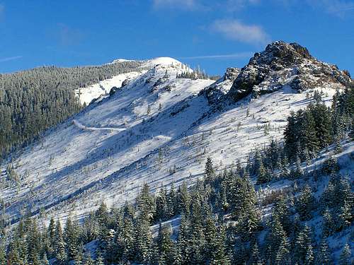
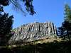
Not to be confused with the North Cascades mountain of the same name that is twice as high, this bare, rocky peak is one of the more prominent landmarks of the Portland area although I doubt most people know what it is. It looks like a long brown ridge from most anywhere in the Portland area and blocks the view of Mt. Adams to the northeast from all but the higher elevations. The reason this one is bare and rocky is not due to its height. Most mountains this high are completely forested. But in 1902, the largest forest fire in Washington's history, the Yacolt Burn, swept through here and trees have failed to regenerate. (from Sullivan's book) The views are some of the best in the southern Washington/northern Oregon area encompassing Rainier, St. Helens, Adams, Hood and Jefferson. All of them look almost within hiking distance. One of the neater aspects of this mountain is that out on an eastern ridge are about 6 ancient Indian stone pits that are said to be where young males would go to fast while on vision quests until they saw "guiding spirits". It's easy to see why they chose this site with the incredible views alone on a windy ridge. There are also some really cool rock formations on this peak. About a mile into the hike you pass Pyramid Rock, a large formation that looks like it would be fun to scramble up and possibly do some technical climbing if the rock is not too crumbly. Further on the trail a bit to the west near the summit is Sturgeon Rock, a sharp peak with basalt columns on two sides. There is also a natural rock arch, 12 feet high and 20 feet long, just below the north face of the north summit. The arch is visible only from below on the Bluff Trail (#172). Behind the arch is a small cave about 8 feet deep. From inside the cave, the arch perfectly frames Mt. Rainier and Mt. St. Helens. There are many ways to access Silver Star Mountain. You can get to the south trailhead from Road 1200 either from the north or the south. You can also hike in one of several trails from the north (Star Way-3.8 mi. path, Edge Trail, Bluff Mountain Trail-5.3 mi. trail -- see the appendix in Sullivan's book for directions). The south trail is 3.3 miles to the summit, is an easy hike along mostly old abandoned roads and gains 2400 feet of elevation. All trails are pretty popular with hikers. I met people on the trail who hike it year-round day and night. There is also a side trail called the Tarbell Trail that takes you past a hidden waterfall but I would not recommend it as it is longer and the view of the waterfall is not very good. The great thing about this mountain is that it has a lot of cool features and is only an hour from Portland.
 |  |  |  |  |
Getting There
From the south (Portland), take I-5 or I-205 across the Columbia River and take Washington State Highway 14 to the east (sign says to Camas). At milepost 16, turn left at the Washougal/15th Street sign. Follow this north through town as it becomes Washougal River Road. Go 6.7 miles and turn left at a small white sign on the left that says Bear Prairie. Go 3 miles to Skamania Mines Road and turn left. Go 2.5 miles to gravel road 1200 and turn left again. Go about 5 and 1/2 miles to the trailhead, a wide area in the road now lined by concrete barrier with a restroom. On the south (left) side of the road is a trail to Larch Mountain, this is NOT the trail you want. You want the unsigned one on the north side of the road. You can also access this from the other side (north) by taking Highway 503 from Vancouver. About 6.5 miles past Battle Ground, turn right on Rock Creek Road (becomes Lucia Falls Road) and go 8.8 miles. Turn right on County Road 12 and go 1.9 miles. Turn right on Dole Valley Road (becomes gravel Road L1000). Go 5.1 miles until you veer left onto Road L1200 and go 4.5 miles to the same trailhead.
 |  |  |
Red Tape
The South Ridge/Tarbell Trailhead (the standard route) requires the Discovery Pass (different from the usual Northwest Forest Pass and not sold at the trailhead). Rangers are there very frequently ticketing so make sure you have the correct Pass. The trailhead is at 2375 feet so as long as the snow is not that low, it should be accessible. Please respect the Native American pit sites and do not disturb the structures or take anything from the area.When To Climb
Year round as long as the roads are open. Mostly though May to December. Snow can stay as late as July here though. Just make sure you check the forecast and know where the snow level is. It can be a great winter hike or snowshoe.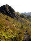 |  |  |
cyffredinol - Jun 5, 2013 12:22 am - Hasn't voted
red tape...At the Tarbell trailhead there is now a sign saying Discovery pass required. Better pick one up before you leave town because they don't sell them at the trailhead.
AbsolutSyd - Jan 3, 2015 8:21 pm - Hasn't voted
Red tape verifiedYou have needed a Discovery pass up there for several years, but people keep tearing down the signs. They do ticket all the way up there as well, so go prepared!